Las Llajas (pronounced, las Yă-Hăs)
San Diego Coquina Limestone (Shell or Oyster Limestone).
The Simi Oil Company owned this land in the early 1900’s. Marrland was purchased by Howard Marr in the 1920’s.
In 1929 Tapo Alto shell and fertilizer company leased the deposit and used it to quarry Limestone where they extracted almost pure Calcium Carbonate (Calcite CaCO3) and produced limestone until 1935. They crushed it for use as Poultry grit, cattle feed , marketed as “Oyster shell meal”, and agricultural needs. The state department of agriculture found it to be 98% pure CaCO3 at that time.
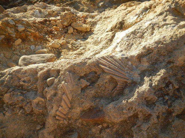
The Geology of middle and upper Las Llajas Canyon is very diverse. One of the rare formations that is exposed in this area, is the San Diego Formation made up of a top layer of a fossilized reef called, “Coquina Limestone”.
Limestone is formed by Compaction and Cementation. The overall process is by Weathering to start off, then Erosion/Transport, deposition/precipitation. In this case we know the Cementation was done by the abundance of Calcium Carbonate CaCO3 (Calcite). Because of the Shells we know it was on the Ocean Bottom.
The Coarse-grained, shell-hash limestone is called Coquina, Whereas the fine-grained limestone composed of the shells of marine microorganisms is what all the kids know as chalk.
This whole area of middle and upper Las Llajas Canyon has had very extreme deformational forces.
Look to the NorthEast at n34 19.006 w118 40.279 and you can see the some of the formation and a slip/strike or tear Fault that pushes the zone to the top of the hill where they were mining the limestone.
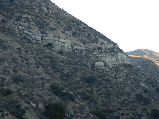
The formation is exposed here and at the top of Las Llajas canyon road where it meets up with Rocky Peak fire road. This is right above where El Toro and Sulphur Canyon meet.(n34 18.868 w118 38.615 if you would like to visit)
This formation is above the Sespe and below the Saugus formation with a thickness of 100 to250’ thick.
The sediments making up the San Diego formation were deposited in very shallow marine waters; the fossils show that it was characteristic of a shallow environment.
Some research has both the San Diego and Saugus Formations having this fossilized reef layer made up of mostly Oysters and Scallops.
The formation above, The Saugus formation doesn’t have the fossils.
Questions, Please E-Mail the answers to me, don’t post in the log!
- Of the three types of Rock. ( Igneous, Metamorphic, sedimentary) which is this Limestone?
- Can you see any evidence of Oyster shell imbedded Limestone?
- What color is the Rock around this location?
- At the Fault view waypoint, what do you estimate the angle of the fault point towards this hilltop?
- At this waypoint how thick is the pure White exposed layer?
Ref:
http://www.rsrpd.org/park/lasllajas/lasllajastrail.html
http://quarriesandbeyond.org
Caltech geology Department
Oregon State university Geology Department
http://hyperphysics.phy-astr.gsu.edu/hbase/geophys/sedime.html
Simi Valley “ A Journey Through Time” The Simi Valley Historical Society and Museum
http://projetoconchas.ufsc.br/upload/arquivos/1198006502.PDF (oyster shell composition)