Nachází se zde skalka zvaná Trojhran o nadmořské výšce 673 metrů na které jsou vyryty četné letopočty jako doklady hraničních revizí, nejstarší datum je z roku 1657. Stýkaly se zde hranice panství Rumburk, Zákupy a Žitava. Na skalce jsou vyryta počáteční písmena všech (R = Rumburk, RE = Reichstadt, Zákupy a Z = Zittau, Žitava).
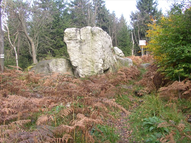 Skalka Trojhranu/Fels Dreiecker
Z geologického hlediska je pískovcová skalka zajímavá tím, že na jejím temeni jsou skalní mísy, které jsou z části propojené žlábky.
Víc napsat nemohu, vše další bude zjistit vaším úkolem.
1) Popište vlastními slovy, jak mohly vzniknout na temeni Trojhranu skalní mísy.
2) Kolik je na temeni Trojhranu větších skalních mís, jaké rozměry má největší skalní mísa a jaká je hloubka nejhlubší skalní mísy?
3) Co ještě vidíte na ploše, kde se nachází skalní mísy?
4) Budu moc rád, když připojíte své foto před skalkou.
Odpovědi zašlete na email mirek256@seznam.cz
[EN] The place I want to show is at the border of the Czech Republic and Germany. At the coordinates the border runs straight north and the Šluknov Hook begins.
The Dreiecker is a small rock of sandstone which lays 673 m above mean sea level and shows historical borders. The oldest inscription dates back to 1657. At this place meet the dominions of Rumburg, Reichstadt and Zittau. At the rock you can read the first letters of the cities: R = Rumburg, RE = Reichstadt, Z = Zittau.
Interesting for geologists are the rock bowls at the top of the rock of sandstone. They are connected with canals.
For more interesting geological details and the answers of the questions visit the place of the coordinates and look at the rock.
1) Describe with your own words how the rock bowl at the top of the Dreiecker had been developed.
2) How many of the big rock bowls can you see? How big is the biggest rock bowl and how deep is the deepest one?
3) What else can you see at the Dreiecker?
4) It would be nice if you would take a photo of yours in front of the rock.
The answers please send to mirek256@seznam.cz
[DE] Der Ort den ich vorstellen möchte liegt an der Grenze zwischen der Tschechischen Republik und Deutschland, wo diese rechtwinklig nach Norden verläuft und der Schluckenauer Zipfel beginnt.
Der Dreiecker ist ein kleiner Fels aus Sandstein in einer Höhe von 673 m auf dem historische Grenzverläufe eingraviert sind. Der Älteste stammt aus dem Jahr 1657. Hier trafen die Herrschaften Rumburg, Reichstadt und Zittau aufeinander. In den Fels sind die Anfangsbuchstaben R = Rumburg, RE = Reichstadt und Z = Zittau eingraviert.
Aus geologischer Sicht ist der Sandsteinfels interessant, da die an seiner Spitze befindlichen Felsschalen teilweise mit Kanälen verbunden sind.
Mehr ist dazu nicht zu sagen. Die Antworten auf die Fragen werden sich vor Ort ergeben.
1) Beschreibe mit eigenen Worten, wie die Felsschalen auf der Spitze des Dreieckers entstanden sind.
2) Wie viele größere Felsschalen sind vorhanden, wie groß ist die größte Felsschale und tief ist die tiefste Felsschale?
3) Was ist neben den Felsschalen auf dem Dreiecker noch zu sehen?
4) Es wäre schön, wenn ihr ein Foto von euch vor dem Felsen machen würdet.
Die Antworten schickt bitte per Email an mirek256@seznam.cz