This open space area called Woodson
Mountain (or Mount Woodson), once called by natives as the Mountain
of Moonlit Rocks and by early settlers as Cobblestone Peak, now
appears on maps as Woodson Mountain in honor of Dr. Woodson who
homesteaded some nearby property in 1875. Woodson was a surgeon in
the Confederate Army during the Civil War and after achieving local
prominence, the mountain was named in his honor. It currently is
part of the City of
Poway trails system.
Rocks from this mountain were used to
construct the famous Ramona Castle or the Mt. Woodson Castle.
Designed by John Vawter and Emmor B. Weaver, the Mt. Woodson Castle
combines English cottage and French castle influences. It is now
part of the
Mt. Woodson
Golf Club.
A California Conservation Corps (CCC) camp
was built on 40 acres of land at the base of Woodson Mountain in
1933. In 1934 some 300 men were stationed at the camp and were in
charge of building the road to the top of the mountain as well as
lookout towers around the county and a forestry station at Woodson
Mountain.
EDUCATIONAL INFORMATION
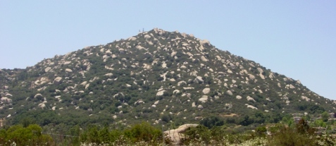
This prominent peak with its distinctive
boulder strewn appearance stands at 2894’ and appears much
different from surrounding peaks in the county. You may have
wondered where did all these boulders came from? Well, they were
actually always there! These boulders formed in place by
spheroidal weathering, which is a form of chemical
weathering in which concentric shells of decayed rock (ranging from
a few millimeters to a couple meters,
WP1
&
WP2
) are successively loosened and separated from a block of rock,
transforming angular blocks into round boulders as you see
today.
These boulders are remnants of rock that
cooled below the earth's surface. As cooling progressed the rock
contracted and cracked
(WP5
). Millions of years later, after uplift brought the rock closer to
the surface, warmer temperatures, elevated atmospheric carbon
dioxide, and decaying vegetation combined with rainfall to
chemically weather the surfaces of the rocks
(WP4
). The degree of weathering was controlled by the ability of these
solutions to penetrate rock. As the decomposed material was
stripped away, large round boulders were left behind to form
boulder strewn hills like Woodson Mountain.
The light colored bedrock of Woodson
Mountain is a type geologist’s call Woodson Mountain Granodiorite
(WP3
&
WP3
). It has speckles of mafic minerals (dark-colored minerals rich in
iron and magnesium), such as biotite (black mica) and hornblende.
Granodiorite is classified by the unique amounts of the framework
minerals know as quartz (30%), plagioclase (50%), and alkali
feldspar (20%) that compose it. This type of rock weathers into
boulder strewn slopes rather than smooth slopes, perfect for the
local rock climbers.
At these views of Highway 67
(WP6
&
WP6
) a road cut shows that weathering along joints forms large, mostly
unweathered rock surrounded by more weathered, softer, browner
material which is easily eroded, leaving the least weathered
rounded rocks in place.
To LOG
this CACHE:
1. Measure the "pealing" thickness of this example of a
weathering boulder located at WP2.
2. Submit with your
log a photo of yourself and GPS at
WP5,
micro-fractures.
To log this cache
e-mail me the
answer
HERE
.
TECHNICAL
Spheroidal weathering:
(“onioning”) is a form of chemical weathering, in which concentric
shells completely surround a corestone. Causes of spheroidal
weathering include the following hypotheses; expansion (several
types), unloading, constant volume alteration, Liesegang phenomena,
micro-cracks, and possibly several other mechanisms. The following
sources were used to generate this cache.
Here's a list of references and additional reading
material:
- Beck, C.D. 2004. On
Memory’s Back Trail: A Story History of Ramona and the Backcountry
of San Diego County. Backcountry Press.
297p.
- Clifford, H.J., F.W.
Bergen, S.G. Spear, & D.M. Burns (ed.) 1996. Geology of San
Diego County: Legacy of the Land. Sunbelt Publications.
175p.
- Kennedy, D. 1999. San
Diego County Climbing Guide. Deadpoint Press.
177p.
- Ollier, C.D. 1971. Causes
of spheroidal weathering. Earth-Science Reviews. Vol. 7,
Issue 3, p. 127-141.
- Ruth, L. 1982. The Ramona
Castle: Irene Amy Strong’s Home and the Craftsman Movement. The
Journal of San Diego History. Vol. 28, No.
3.
- Shad, J. 1992. Afoot
and Afield in San Diego County. 2nd Edition. Wilderness Press.
304p.
- Walawender, M.J. 2000. The
Peninsular Ranges: A Geological Guide to San Diego’s Back
Country. Kendall/Hunt Publishing. 114p.