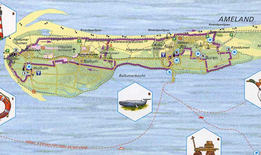
Door toedoen van de getijdestromen, de stand van de bodem in de Waddenzee en de vorm van de eilanden wordt aan de noordkant van het Waddeneiland Ameland continu zand afgezet. Ter hoogte van het dorp Ballum ontstaat een gigantische zandbank als gevolg van deze zandafzettingen, die enkele kilometers uit de kust parallel aan de kust aangroeit, bij vloed niet meer onder water komt te staan en uiteindelijk de kust bereikt. Op het strand ontstaan binnenmeren, waarbij het water nog maar ten dele bij eb kan worden afgevoerd en de poelen aan de zuidkant van de haak grotendeels brak en soms zelfs zoet worden. Bij het ontstaan heeft de bank de vorm van een enorme overhellende haak, vandaar de naam ‘Zandhaak’.
 .
.
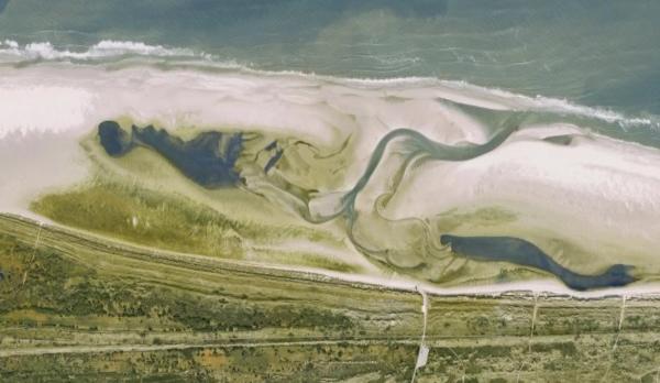
Net voordat de zandhaak door de zandafzettingen de kust bereikt, zorgt het in- en uitstromende zeewater voor een enorme schade aan de duinen. Dit oostelijk gelegen natuurlijke kanaal dicht bij de duinen slibt echter dicht en in het midden van de zandhaak ontstaan nieuwe kanalen. De onderstaande foto (bron: Google Earth) toont de situatie na het ontstaan van de nieuwe af- en aanvoerkanalen in het midden van de zandbank.
Doordat het water slechts ten dele wordt afgevoerd en de poelen aan de zuidkant van de zandhaak brak worden, start er een bijzonder proces op het strand waar allerlei vegetatie begint te groeien. Deze worden normaal gesproken alleen achter de duinenrij gevonden en is duidelijk waarneembaar vanuit de lucht. Het gras groeit er op sommige plaatsen manshoog en het biedt in het voorjaar een uitstekend biotoop voor broedende vogels, zoals sternen en plevieren.
De groei van deze vegetatie op het strand is een voor Nederland uniek natuurfenomeen. Het geheel is ook een cyclisch fenomeen waarbij de vegetatie op den duur weer verdwijnt door opdroging van de binnenmeren en -poelen. Ook de zandhaak wordt weer langzaam in zee opgenomen, en uiteindelijk krijgt het strand zijn normale proporties weer terug (zie luchtfoto). Daarna begint het hele proces opnieuw.
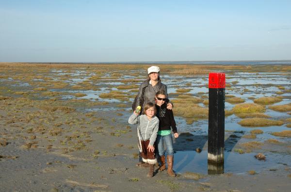
Om deze Earthcache te kunnen loggen moet je op het gegeven waypoint een foto maken bij de strandpaal, in de richting van het noord-westen, met je GPS zichtbaar in je hand, en de vegetatie/zandhaak op de achtergrond. Voeg deze foto bij je log.
Daarbij moet je mij ook nog het antwoord mailen op de volgende vraag:
Hoe lang duurt de totale cyclus van het ontstaan en verdwijnen van dit fenomeen?
Het antwoord schijn je tegenwoordig te kunnen vinden bij de strandwachten en in elk geval op internet.
Logs zonder foto of zonder begeleidende email met goed antwoord, zullen helaas worden verwijderd.
English
Because of tidal streams, the bottom of the Wadden Sea and the form of the islands, sand is constantly being deposited at the north side of the Wadden island Ameland. At the village Ballum a huge sand bank is being formed which stretches for kilometres along the coastal line. The sand bank is no longer flooded during high tide and finally over time, reaches the shore in the east. On the beach inner lakes are formed from where the water can only be partly dispatched during low tide. At these inner lakes and water holes the water gets sweeter over time. During its first appearance the sand bank is formed in a the shape of a hook, explaining the name sand hook, or ‘Zandhaak’.
Just before the sand hook reaches the shore in the east, the in- and out streaming seawater causes quite dramatic damages to the dune stroke. However, the naturally formed canal fills up with sand and in the middle of the hook, new canals are formed. The picture (source: Google Earth) shows the situation right after the appearance of the new canals.
Because the water is only deposited partly, the water holes and lake, south of the sand hook get sweeter and a rare process starts in that vegetation starts to appear and grow. This vegetation is normally only found behind the dunes, not at the beach. The grass grows at certain places mans high and offers an excellent breeding area for birds in spring time.
The growth of this type of vegetation on a beach is a unique natural phenomenon in the Netherlands and along the North Sea coast. The entire process is also cyclic, in which the vegetation disappears because of the drying up of the inner lakes and water holes. The sand hook also disappears in time and the beach gets back to its ‘normal’ proportions (see picture from the sky). Thereafter, the entire process repeats itself.
To log this Earthcache, you need to make a picture at the given waypoint at the pole in the NW direction, with your GPS clearly shown, and the vegetation/sand hook clearly in the background.
With that, you need to email me the answer to the following question:
How long does one cycle of this phenomenon at the Ballumer beach take?
The answer to the question can apparently be found at the lifeguards place and certainly on the internet (sites mostly in Dutch though).
Logs without a picture or without accompanying email with correct answer have to be deleted unfortunately.