O opuce
Opuka je druh usazené horniny. Jedná se o prachovitý druh slínovce vzniklý z jemných částic usazených na dně druhohorního moře. Skládá se z jílovitých a prachovitých částic, vápencových složek a mikroskopických jehlic mořských hub (spongie). Typ opuky s velkým množstvím těchto jehlic se nazývá spongilit. Barva je podle poměrů jednotlivých složek pískově žlutá až šedá. Hustota horniny je 2 000 - 2 200 kg/m3. Jedná se o kvalitní stavební kámen, který byl oblíben zvláště ve středověku. Opuka není vhodná k výrobě drceného kameniva. Je však dobře opracovatelná a může sloužit i k sochařským účelům. Z tohoto důvodu ji často naleznete i daleko od přírodních nalezišť.
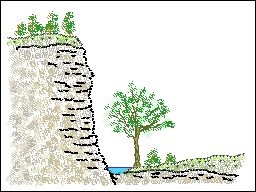
Opukový svah
Na místě, kam vás dovede tato earthcache, můžete vidět opukový svah na protějším břehu řeky Labe. Odkryté opukové svahy obvykle najdete v lomech, kde k odkryvu došlo těžbou tohoto stavebního materiálu. Tento odkrytý svah však vznikl přírodní cestou v důsledku zlomu, vyzvednutí části masivu a následné eroze. Na schématu vpravo je znázorněn řez, kde je patrná rozdílná výška břehů. Oblast v pravé části obrázku je často ohrožena povodněmi.
Kudy na místo
Zaparkujte na jednom z doporučených míst (PARK01 nebo PARK02) a dál jděte pěšky do finálního bodu (FINAL). Chcete-li si svah prohlédnout zblízka, přebroďte řeku. Od jihu není earthcache dostupná, je zde soukromý pozemek! Po svahu nelezte a neničte jej, hrozí pád nejen kamení, ale i vás!
Otázky
Pro zalogování odpovězte na tyto čtyři jednoduché otázky:
1. Kolik tun by přibližně vážila opuková krychle o hraně 1 metr? (viz listing)
2. Jaká je přibližná výška svahu v místě EC (v metrech)?
3. Jaká je přibližná šířka řeky v místě EC (v metrech)?
4. Nad úrovní hladiny jsou ve skále zřetelné pukliny napříč vrstvami kamene. Jaký je jejich směr?
Odpovědi mi zašlete přes profil a zalogujte nález. Pokud by odpovědi nebyly správné, ozvu se. A samozřejmě se tu můžete vyfotit a fotku přidat k logu.
[EN]
About Opuka
Opuka is a type of sedimentary rock. It is the silty type of marlstone originated from fine elements settled at the bottom of mesozoic sea. The rock consists of clays and silty elements, calcite components, and microscopical spines of sea sponges. The type with a large number of the spines is called spongilit. Color of the rock depends on the amount of the components, and can be from sandy yellow to gray. The mass density of this rock is about 2,000 - 2,200 kg/m3. It is a high-quality building stone, which was popular specially in medieval times. The Opuka is not good source for road-metal or broken stone. But, it is well workable and can be used for sculptural purposes and statuary. By this reason, you can see it far from its natural finding places.
Opuka slope
You can see the Opuka slope on the oposite bank of Labe river from the place where this earthcache leads you. You can find uncovered Opuka slopes in the stone quarries commonly, where the uncovering comes from the quarrying of the building stone. However, our uncovered slope grows up by nature as the effect of fault, shift of the part of massif, and consecutive erosion. You can see the different level of the river banks on the terrain-cut in the schematic picture in the right. The right part of the land is often in danger of flood.
Which way to go
Use one of the recommended parkings (PARK01 or PARK02) and walk to the final point (FINAL). If you wish to see the slope in detail, you have to wade through the river. The earthcache is NOT accessible from south-side because of privat area! Do not climb the slope, and do not damage it! There can be the danger of fall of not only the stones, but of you too.
Questions
Please, answer this four simple question for the "found it" logging:
1. About how many tons would be the weight of a cubic meter of Opuka? (see listing)
2. What is the approximate height of the slope in the EC location (in meters)?
3. What is the approximate width of the river in the EC location (in meters)?
4. There are apparent cracks across the layers few meters above the river level. What is their direction?
Send the answers using the profile message, and just log the EC. I'll send a reply in the case of bad answer only. Furthermore, of course, you can take a picture with or without you in this location, and add it to the log.