Druid Lake is a kettle lake located in the Town of Erin,
Wisconsin. The coordinates listed for this cache are at the public
boat launch. This lake is a gem that much of the local community is
gathered around. Glacial topography is key to why The Town of Erin
is one of the oldest settled and incorporated towns in Washington
County: January 6th, 1846. The highest point in southeastern
Wisconsin is also here at Holy Hill which brings ten of thousands
of visitors each year. The lake and Holy Hill are both social,
economic and geologic the cornerstones of The Town of Erin.
Druid Kettle Lake was formed during the most recent North American
Glaciation, the Wisconsin glacier (10,000 to 100,000 years ago).
They are formed when a large piece of ice breaks away from the edge
of a retreating glacier, and becomes partially buried under
sediment deposited by the glacier. Over time these huge lumps of
underground ice would melt and the top-soil caved in to form
isolated kettle lakes. If the level of this hole is below the water
table, it fills with water and becomes what is known as a kettle
lake or hole. Kettles above the local water table may fill
seasonally and be dry at other times. Kettle holes can also occur
in ridge shaped deposits of loose rock fragments called till. Not
part of any river system, they fill with local snow run-off &
rain, and then may dry out in the summer heat.
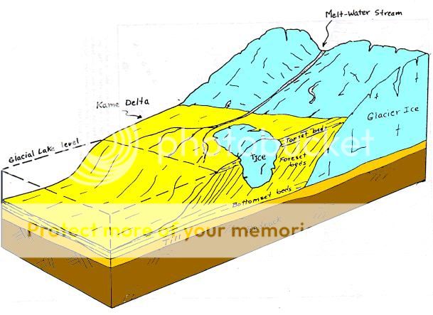
The diagram shows a huge block of ice broken off
a reatreating glacier.
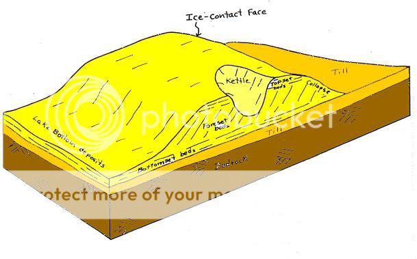
The diagram shows the remaining divit or kettle
after block of ice has melted.
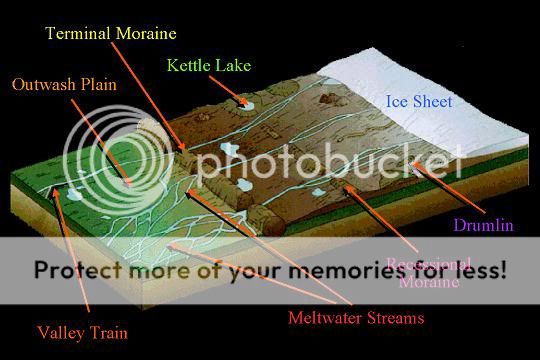
The many potential features made by a retreating
glacier are shown here.
LOGGING THIS
EARTHCACHE
In order to log this earthcache:
1. Email me the answers to
these questions:
a. Look at the surrounding
topography of kettle. Do you think this kettle is above or below
the local water table?
b. Do you think the water level
of this kettle fluctuates very much during the year? Look at the
shoreline for evidence of water lines (dried mineral deposits) on
rocks or other debris.
c. What does the kettle's edge
look like: sandy, muddy, rocky?
2. Take a self photo with your
GPS or your team with a GPS at the sign. Then post the photo
with your log. If you're a lone cacher, hold your camera at
arms length to get a self photo, please.
This task is optional.

Do you want to be rewarded for visiting more
earthcaches? Then become a member of the new Earthcache
Masters Program. Visit three or more earthcache sites to
start receiving collectable pins. There are four levels: bronze,
silver, gold and platinum. It is free and easy to participate.
Check out the
details! Find
earthcache listings near you.