This is not your typical Geocache, it is an Earthcache, you will not find a "cache container" rather, an Earthcache is designed to bring you to a geological feature to learn something about our great Earth. See http://www.earthcache.org/ for further details
ABOUT THIS EARTHCACHE LOCATION
This Earthcache is located in The Watchung Mountain Reservation, "Watchung" is a Lenape Indian word meaning "High Hill". The mountains have an elevation of 600 feet above sea level.
The Watchung Mountains are underlain by basalt layers. The valleys and lowland between these mountain ridges are underlain by shale and sandstone.
The Watchung Reservation Earthcache will take you on a short hike to 7 location where you can get a sense of the geology of the Watchung mountains, and how it was formed and became part of this area.
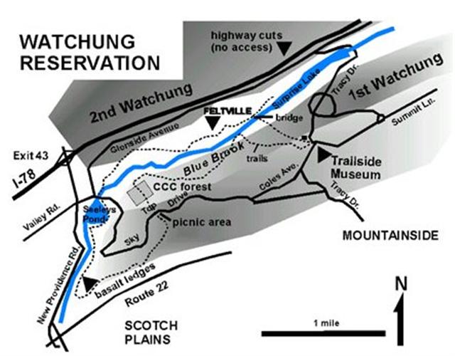
The published coordinates will take you to the top of the parking lot of The Trailside Nature and Science center. This is the starting point, (Basalt Outcrop) of the 7 geology locations you will be visiting.
While there, stop into the center and visit the Geology and mineral exhibit, pick up a trail map and Geology hike brochure.
From the parking lot of the Trailside Nature and Science center you are standing on the ridge of the first Watchung Mountains, formed by the first and oldest lava flow. Look toward the west, downhill to see the second mountain ridge. The low area bertween these ridges formed as the softer sandstones and shales were worn away.
To continue your Earthcach, proceed West, downhill to access the orange and blue trails to locate the next Earthcache location, The Old Carriage roadway.
HISTORICAL INFORMATION
The Watchung Reservation geologic area is part of the Newark Basin. The area was formed nearly 200 million years ago during the Jurassic period.
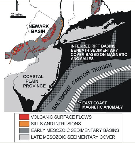
The Watchung Reservation was once a valley where layers of sand and mud were collected and deposited. Over millions of years, these layers eventually hardened into sedimentary rock. As the earth crust stretched and formed cracks, lava found their way to the surface and spread across the surface, it cooled and hardened into igneous rock.
The Watchung Reservation area had three lava flows over the course of several million years, each separated by layers of sand and mud now compacted into hard rock called sandstone and shale.
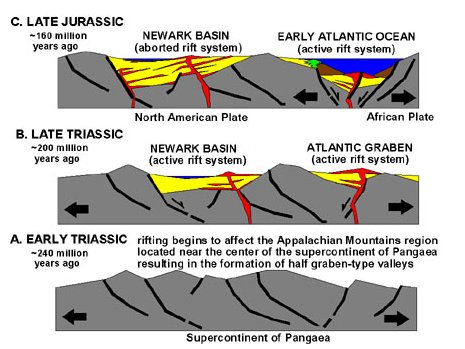
There were four major glacial periods during which glaciers moved across portions of North America, including Northern New Jersey. These glaciers were formed over 1 million years ago when the Earth climate cooled causing snow and ice to accumulate forming great ice sheet called continental glaciers. These glaciers contained frozen soil and rocks of all sizes which were carries south with the glacier movement. The glacier did not travel much further south then the Watchung Reservation, as it melted the materials settled to the ground to form a blanket of sediment over the surface.
GEOLOGICAL INFORMATION
1. Basalt Outcrop (Published Coordinates) Top of Parking Lot. N40 41.003 W074 22.368
Located at the top of the parking lot, going towards the Nature center, is an outcrop of basalt. Notice the step like structure which formed as the lava cooled.
Basalt is formed by cooling of magma that has been extruded onto the surface as lava. Basalt is more resistant to erosion than the enclosing sandstone and shale and therefore they form ridges and uplands. Basalt is also called trap rock, from the Scandinavian word "treppe" which means stair, The chemical weathering and oxidation of the iron-rich basalt produces its rusty color.
2. Old Carriage roadway - erosion
N40 40.946 W074 22.576
Follow the Orange trail which was once an old carriage roadway, which lead to the old historic Feltville Mill town, now the Deserted Village. This slightly steep trail has experienced Erosion which started from the wagons, and occurs each time a hiker walks down the trail. Also, During rain storms the soil is loosened and washed away. Steps were made of logs and installed in the trail to help stop the soil and rocks from being washed away. This erosion will continue over time and make a greater depression along the trail.
3. Conglomerate / Puddingstone Boulder
N40 40.943 W074 22.682
Continue down the trail and look for a large boulder on your left. This boulder is an example of a glacier erratic. This large purple and white boulder was carried by the great glacier and dropped here in the Watchung Mountains about 1 million years ago. It is a conglomerate because of the various white quartz pebbles and purple quartzite in a purple hematite-stained matrix. This boulder originated in the Green Pond area of Morris and Sussex counties. Its is know as a Green pond Conglomerate or puddingstone.
4. Surface of Lava Flow
N40 40.962 W074 22.713
Continue down the trail and look for a bumpy gray rock surface in the middle of the trail. This is one of the lava flows that make up the First Watchung Mountains. The many cracks were formed when the lava contracted when it cooled and hardened.
5. Glacial Erratics
N40 40.964 W074 22.729
Continue down the trail and look for two large boulders on the right. These are "glacial erratics", which is term that refers to any rock or boulders that was frozen into glacial ice and carried during its southward journey and deposited.
6. Red Shale
N40 40.985 W074 22.777
Continue down the trail and look and look to the right for some reddish brown sedimentary rocks called shale. This formation is part of the Feltville formation and is approximately 600 feet thick and overlies the basalt of the Orange Mountain Formation that forms the First Watchung Mountain. This Feltville Formation is covered by another lava flow, known as the Preakness Basalt that forms the Second Watchung Mountain.
The Red Shale is thinly layered and breaks easily into sheets. Its has a sparkly surface caused by bits if mica deposited by the mud, Intermixed with the shale are blockier layer beds of red sandstone. The beds are tipped slightly to the Northwest. Most of the rocks in the Newark Basin dip in this direction at an angle of 15 degrees. This is caused by the movement of the Earth's crust as the continental plates drifted apart at form the Atlantic Ocean.
7. Gray Shale
N40 41.030 W074 22.819
Continue down the trail and turn right onto the larger bridle trail. Walk along the trail and notice the smaller trees to your right with their lower portion of their trunks curved in a downward direction. This is caused and evidence of a form of erosion called soil creep. The gravity pulls the soil on steep hillsides slowly downhill. As these trees on the hillside grow, they constantly adjust their growth direction to remain upright. At this location the thin papery pieces of shale are a gray color, which indicates that these sediments were continuously covered with water, most likely in a deep lake or swamp.
The Red shale and sandstones were deposited along the edges of lakes and swamps, such an area where seasonal drying occurred. The red color is due to the chemical reaction of oxygen in the atmosphere with the iron in the rock.
TO LOG THIS EARTHCACHE, YOU MUST COMPLETE THE FOLLOWING TASKS. FAILURE TO COMPLETE THESE TASKS WILL RESULT IN LOG DELETION WITHOUT NOTICE.
1. BRING YOUR CAMERA, You must take a photo of you and or your team with your GPS at one or more of the Earthcache locations, if you are solo, a photo of your GPS is fine.
2. Lava Flow location task
Study the random patterns of the Lava flow, then estimate how much surface area can you see on the trail. Post you estimate in you log.
3. Conglomerate / Puddingstone Boulder location task
Study the boulder and estimate how many white quartz pebble stones you think are within the boulder? Also, how many different colors in the Boulder can you count? Post you estimate and colors with you log.
4. Glacial Erratics location task
Look around, identify and see how many total Glacial Erratics you can count in this area?
5. Red Shale location task
Locate one of the outcrops of the red shale rocks along the hillside. Closely examine and study, but DO NOT DISTURB this red shale, count or estimate how many thin layers make up the shale rock you are examining?
6. Gray shale location task
Locate a good example of the soil creep on the steep hillside causing the trees to grow as described. Take a photo of a good example of the lower curved tree trunk and post it with your log.
EARTHCACHE.ORG GUIDELINES FOR LOGGING AN EARTHCACHE:
EarthCache sites must provide Earth science lessons. They take people to sites that can help explain the formation of landscapes or to sites of interesting phenomena such as folds, faults, intrusions or reveal how scientists understand our Earth (such as fossil sites etc.) EarthCache sites must be educational. They provide accurate but simple explanations of what visitors will experience at the site. Logging of an EarthCache must involve visitors undertaking some educational task that relates to the Earth science at the site. This could involve measuring or estimating the size of some feature or aspect of the site, collecting and recording data
I am pleased to be able to share the beauty and Geology of the Watchung Mountain Reservation with you through this Earthcache.
Please be advised, failure to complete all the tasks listed above and posting your (photo) will result in log deletion.
MOST IMPORTANT - ENJOY YOUR VISIT!