Askja was virtually unknown until the tremendous eruption which started on March 29, 1875. Especially in the eastern fjords of Iceland, the ashfall was heavy enough to poison the land and kill livestock. Ash, or tephra from this eruption was wind-blown to Norway and Sweden. The eruption triggered a substantial wave of emigration from Iceland. Another less well-known eruption occurred in the early Holocene, ca 11,000 years ago. Tephra from this eruption has been found in south-east Sweden, Northern Ireland and north Norway.
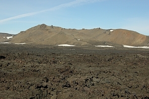
The outer caldera of Askja, representing a prehistoric eruption, is about 45 km², and there is evidence of other later caldera-forming events within it. The main crater floor lies at about 1,100m.
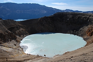
Öskjuvatn is a large lake that fills much of the smaller caldera resulting from the 1875 eruption. Its surface lies about 50m below the level of the main crater floor and covers about 12km². When the lake originally formed it was warm, but today it is frozen over for most of the year. Öskjuvatn is the deepest lake in Iceland at 220 m deep.
Viti is a smaller explosion crater on the north east shore of Öskjuvatn, approximately 100 metres diameter. It contains a geothermal lake of mineral-rich, sulphurous, opaque blue water, which is maintained at a comfortable temperature for swimming.
To receive credit for this earthcache, you have to email 3 of 5 answers of the following questions. A photo of you and your gps at the coordinates (above viti) is optional, but I would be very happy to see pictures from the Askja viti region. (look at the attached picture at the listing).
Please note!!
Do not include the answers in your log.
The questions:
1. In which year was viti formed?
2. How hot could the hot spots be that are warned of?
3. What means viti in icelandic speech?
4. When did the last 3 known eruptions take place in the askja area?
5. Explain in few simple words the difference between the both lava-types.
How to reach the cache area:
Askja is a popular destination. You can reach it by driving the tacks F88,F910 and F894 with an off-road-car (100km from the ring-road Nr. 1) or by a guided bustour.
The coordinates of the parking lot: N 65 04.025 W 016 43.489
From there it is a half hour´s walk to the coordinates of the cache. There is a marked 2,5km way to Öskjuvatn and Víti.
Please don´t leave this way.
There are two mountain huts and a campsite at Dreki, by Drekagil nearby. A walk to the dragon waterfalls is really interesting.
Please note!!
The roads are usually only open for about two or three months in high summer. You have to cross small rivers.
More information about the roads: Vegagerdin and weather: Vedur
Source: (some parts) wikipedia
I wish you a nice trip and a great adventure at this great area. I enjoyed it much this summer.
Greetings, wegaworld