Spring Is Here, Willow Spring That Is EarthCache
Spring Is Here, Willow Spring That Is
-
Difficulty:
-

-
Terrain:
-
Size:  (other)
Please note Use of geocaching.com services is subject to the terms and conditions
in our disclaimer.
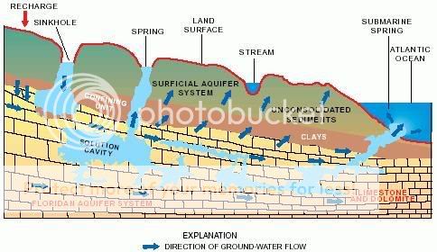
What is a Natural Spring?
A spring is a point where groundwater flows out of the ground, and is thus where the aquifer surface meets the ground surface.
Dependent upon the constancy of the water source (rainfall or snowmelt that infiltrates the earth), a spring may be ephemeral (intermittent) or perennial (continuous).
Background History of the Spring
In the 1800's settlers built a small stone structure over the spring to keep the horses and cows from polluting it. In 1963 the area was a cattle feed lot. To this day if you dig about two feet down you can still smell the "residue" from the former occupants.
Eight years ago the stone building was in disrepair and hidden by weeds. With the help of a couple of long time residents the area was cleaned up, framed and the roof was shingled (at their own expense).
Update
recently there have been goldfish placed in the spring. So, be sure to watch for them. Who knows perhaps you'll find Nemo.
It is located just off of a paved trail so it could potentially be claimed by those in a wheelchair but you may want to bring someone else with you just in case. As you will see in the photos it has been by another. Just wanted to mention that so all can get a chance to enjoy this.
According to a hydrologist that works with the USGS, NE Water and Science Center, it is doubtful that the water freezes over here as in Nebraska, ground water typically maintains a temperature of between 55-60 degrees year round. The spring itself is located in the Bignell and Peorian Loesses and has a thin deposit of Bignell and Peorian Loesses (many times considered one geologic formation) overlying Loveland Loess. Sometimes springs occur at the contact of these two formations. The spring is the result of seepage from the geologic contact of the younger Bignell/Peorian Loess and the underlying Loveland Loess. Although this spring is located in Nebraska it is not a part of the High Plains Aquifer System/Ogallala Aquifer which is one of the world’s largest aquifers.
Springs are classified by their flow rate, or water discharge, by the term Magnitude. The largest springs are called "First-Magnitude," and they are springs that discharge water at a rate of at least 2800 L/s. The scale for spring flow is as follows:
| Magnitude |
Flow (ft³/s, gal/min, pint/min) |
Flow (L/s) |
| 1st Magnitude |
> 100 ft³/s |
2800 L/s |
| 2nd Magnitude |
10 to 100 ft³/s |
280 to 2800 L/s |
| 3rd Magnitude |
1 to 10 ft³/s |
28 to 280 L/s |
| 4th Magnitude |
100 US gal/min to 1 ft³/s (448 US gal/min) |
6.3 to 28 L/s |
| 5th Magnitude |
10 to 100 gal/min |
0.63 to 6.3 L/s |
| 6th Magnitude |
1 to 10 gal/min |
63 to 630 mL/s |
| 7th Magnitude |
1 pint to 1 gal/min |
8 to 63 mL/s |
| 8th Magnitude |
Less than 1 pint/min |
8 mL/s |
| 0 Magnitude |
no flow (sites of past/historic flow) |
None |
To Claim Credit For This Earthcache:
You will need to bring a thermometer and a camera
1) For educational purposes you must email a temperature reading from the spring at the time of your visit.Do not post your reading with your log entry
2) Then, include in your email your best guess of the magnitude of flow from the spring following the chart listed above again do not include this in your log entry.
3) Finally, you must take a picture of either you or something at the location and post it on the site with your log entry
Thanks to:
Wikipedia for information about Natural Springs
U.S. Geological Survey’s NE Water Science Center for information about this spring
USGS Georgia Water Science Center for the great aquifer diagram
tjstheone for being in the right place at the right time gaining history on this spring
Bellevue Parks Dept for permission in placing this cache
bosac and catsnfish for help with ideas for this cache
Hope you learned something and enjoy
Additional Hints
(No hints available.)