
 As you travel up the canyon toward the coordinates the
canyon narrows. The walls shoot straight up a couple of
hundred feet. Beyond the coordinates, the canyon narrows to
just the width of a car. This type of canyon is called a slot
canyon. Slot canyons typically form where the surrounding rock
is strong enough to support itself and the region is being
uplifted quickly.
As you travel up the canyon toward the coordinates the
canyon narrows. The walls shoot straight up a couple of
hundred feet. Beyond the coordinates, the canyon narrows to
just the width of a car. This type of canyon is called a slot
canyon. Slot canyons typically form where the surrounding rock
is strong enough to support itself and the region is being
uplifted quickly.
 Fast uplift increases the difference between the
elevation of the streambed and the stream’s base level and
moves the profile of the stream away from its ideal profile.
The base level is the theoretical minimum elevation that a
stream will reach, effectively sea level (or below sea level
in the case of Death Valley or the Salton Sea). However, there
can be temporary base levels, lakes and ponds. The ideal
profile of a stream is concave upward, almost flat near the
base level and gently increasing in slope near the start of
the stream in the mountains (headwaters). In the figure, the
stream erodes at points “C” where the topography is above the
ideal profile, in this case, the slot canyon. The stream
deposits its sediment at points “F” where the topography is
below the ideal profile, here in Anza Borrego that would be
the alluvial fans.
Fast uplift increases the difference between the
elevation of the streambed and the stream’s base level and
moves the profile of the stream away from its ideal profile.
The base level is the theoretical minimum elevation that a
stream will reach, effectively sea level (or below sea level
in the case of Death Valley or the Salton Sea). However, there
can be temporary base levels, lakes and ponds. The ideal
profile of a stream is concave upward, almost flat near the
base level and gently increasing in slope near the start of
the stream in the mountains (headwaters). In the figure, the
stream erodes at points “C” where the topography is above the
ideal profile, in this case, the slot canyon. The stream
deposits its sediment at points “F” where the topography is
below the ideal profile, here in Anza Borrego that would be
the alluvial fans.
Image source: Manning, 1967
http://www2.nature.nps.gov/geology/usgsnps/
noca/sb16river.html
The further from the ideal profile, the greater the erosional
potential of the water traveling in the stream since the water will
travel faster along the steeper streambed.  As a result, the water erodes quickly down
through the underlying bedrock faster than the water erosion
can create a typical “V” shaped valley.
As a result, the water erodes quickly down
through the underlying bedrock faster than the water erosion
can create a typical “V” shaped valley.
Over time, other erosional processes will act on the high walls
of the slot canyon to widen it up and create a characteristic “V”
shaped valley. Because this has not happed yet, geologists assume
that this is a geologically young canyon.
At the coordinates you will find crossbeds in the sandstone
walls. Cross-beds are formed by layers of sand grains as they build
up into a dune then collapse. Wind piles sand up the gentle
windward side of a dune. When the dune becomes too steep to support
itself, it collapses creating the angled layers. 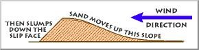 This process also slowly inches the dune in the
direction of the wind. Source USGS:
http://www2.nature.nps.gov/geology/usgsnps/
This process also slowly inches the dune in the
direction of the wind. Source USGS:
http://www2.nature.nps.gov/geology/usgsnps/
dune/dune.html
Over time, the next dune migrates over the first, burying the
first and preserving the crossbeds. The USGS Western Coastal &
Marine Geology website has some downloadable movies to demonstrate
the process (http://walrus.wr.usgs.gov/seds/Movie_list.html).
 One of the sources I used says there are also
ripple marks and fossil animal tracks in the canyon, but I was
unable to find them.
One of the sources I used says there are also
ripple marks and fossil animal tracks in the canyon, but I was
unable to find them.
Logging requirements:
Send me a note with :
- The text "GCZ5X8 Sandstone Canyon – Anza Borrego SP" on the
first line
- The number of people in your group.
- Post the coordinates and pictures of any of the features I
couldn't find (if you can find them)
- Send me a note with the direction the water was moving when the
crossbeds were formed based only on the flat rock
surface.
The above information was compiled from the
following sources:
- Paul Remeika and Lowell Linsay,
Geology of Anza-Borrego: Edge of Creation, Kendall/Hunt Publishing
Company, Dubuque, Iowa, 1992
- USGS: http://www2.nature.nps.gov/geology/
usgsnps/dune/dune.html
- Manning, 1967, (The Nation Park Service page
that used this image provides this reference, but does not have
additional information)
http://www2.nature.nps.gov/geology/usgsnps/noca/sb16river.html
- USGS:
http://www2.nature.nps.gov/geology/usgsnps/dune/dune.html