DEATH VALLEY The valley itself is 130 miles (210 km) long, between six and 13 miles (10-21 km) wide and is surrounded by steep mountain ranges: the Panamint mountains to the west, and the Black, Funeral, and Grapevine mountains to the east. Its three million acres of wilderness and rich cultural history make it a lifetime's work to explore all that the valley has to offer. Death Valley National Park is the lowest point in the Western Hemisphere and one of the hottest places in the world. It is also a vast geological museum, containing examples of most of the earth's geological eras. Telescope Peak, the highest peak in the Park and in the Panamint Mountains, rises 11,049 feet above sea level and lies only 15 miles from the lowest point in the United States in the Badwater Basin salt pan, 282 feet below sea level. Death Valley is one of the hottest places in the world. Air temperatures over 120 °F (49 °C) are common during the summer months of June, July, August and September. The record high in the park was recorded in 1913 at a blazing 134 °F (57 °C). A land of extremes, there are locations within the park that allow the visitor to see both the lowest and highest elevations in the 48 contiguous United States on a clear day. As far as US phenomena occur, not only does it feature the hottest recorded temperature, but also reports the lowest annual precipitation, the tallest sand dunes, and at 13,628 square kilometers, is the largest National Park in the 48 contiguous United States. Despite its reputation as a lifeless wasteland, Death Valley National Park contains a great diversity of plants. The park covers over 3 million acres of Mojave and Great Basin desert terrain, with elevations ranging from 282 feet below sea level at Badwater Basin to 11,049 feet on the summit of Telescope Peak. Annual precipitation varies from 1.9 inches on the valley floor to over 15 inches in the higher mountains. Vegetation zones include creosote bush, desert holly, and mesquite at the lower elevations up through shadscale, blackbrush, Joshua tree, pinyon-juniper, to sub-alpine limber pine and bristlecone pine woodlands. The saltpan is devoid of vegetation, and the rest of the valley floor and lower slopes have sparse cover, yet where water is available, an abundance of vegetation is usually present.
Some very interesting geological features can be found in the Darwin Canyon. Darwin Canyon can be easily (but not quickly) reached by traveling west from Panamint Springs on CA 190 to the paved turn-off to the town of Darwin. This turnoff is about 18.5 miles west of Panamint Springs. 5.8 miles after the turn, you will arrive in “downtown” Darwin. A left turn (east) in the center of town and then generally keeping left up the hill will bring you to a summit on a semi-paved road. This will continue down a very steep hill into Darwin Canyon whereupon the road will turn to gravel. After 4.0 miles from the center of Darwin you will come to a pump house (Miller’s Spring). The next several miles have numerous geologic features that are very closely spaced.
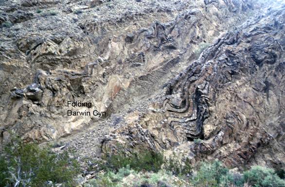
The first geological feature we will examine are the Darwin Canyon Folds. These highly folded rocks are severely weathered and in some places the folding is not obvious. The folds are better on the south canyon wall. These rocks are lower Permian in age and belong to the Darwin Canyon formation. This folding probably occurred prior to the creation of the angular unconformity less than ½ mile farther down-canyon. The folds are within a limb of a much broader series of folds that strike roughly north-south and are probably the result of incompetent beds giving way during the major compression that created the larger folds.
The second geological feature we will look at is angular unconformity. The angular unconformity is obvious on the north (left) side of the canyon 0.4 miles down canyon from the folds. The layers below the unconformity are the lower Permian Darwin Canyon formation seen at the folds up-canyon. The layers on top are Triassic marine deposits. The youngest fossils in the beds from under the unconformity are Wolfcampian fusilinids of the Panamint Springs member of the Darwin Canyon formation. The oldest fossils from the layers above the unconformity are Guadelupian (Capitanian) brachiopods and mollusks. This and other evidence indicates a late Leonardian age for the unconformity, or an age of about 258 Ma in the uppermost lower Permian. Looking above and to the right of the unconformity, there are some faults within the sedimentary rocks.

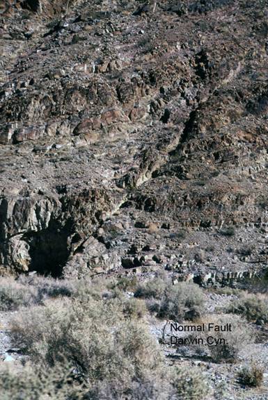
The third geological feature in Darwin Canyon are the faults. The best fault is located 0.2 miles further down the canyon from the unconformity. It is in the sediments in the left wall of the canyon. There are many faults that cut through the rocks in Darwin Canyon. Some are reverse and thrust faults probably related to the folding and uplift that produced the angular unconformity seen up the canyon from here. This large fault is normal and most likely related to Neogene extensional tectonics and not the compressional events manifested in the two previous stops. Note the folding of the layers along the fault zone indicating the motion of both the hanging wall and the footwall.
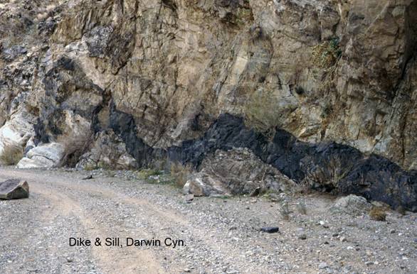
The fourth and last geological feature we will examine in the Darwin Canyon is the dike and sill. From the faults, continue down the canyon for 1.1 more miles. You will come to a junction. Keep left down the wash for 0.6 miles to China Garden Spring. Park near here and continue walking down the canyon for about 1/3 mile more, past the gate. China Garden Spring is only one of numerous outflows of groundwater in Darwin Canyon. There is water at the pump house up-canyon and just below this location Darwin Falls can be quite dramatic. Darwin Falls can be reached by hiking down the canyon from the dike/sill or up from a parking area accessed off a dirt road off of CA 190 just west of Panamint Springs. At China Garden Spring, human activity has built up ponds, a berm and the ruins of several buildings can be seen. On the hike to the dike/sill note a large outcrop of epidote on the left canyon wall. This is related to the Mesozoic granitic intrusions which are common in the mountains surrounding the northern Panamint Valley. You will notice a dark basalt injection that cuts across the grain of the sedimentary rocks, then follows the bedding for awhile and then cuts across the grain again. The basalt is most likely a Pliocene age injection as these are common just north of here. The sedimentary rocks are those seen at the previous sites up the canyon.
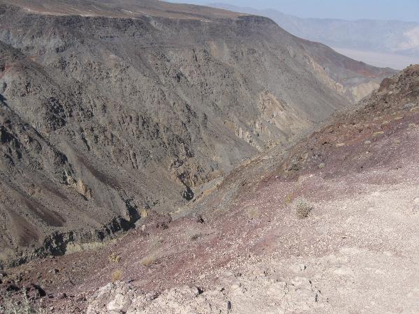
I also wanted to mention a little bit about the geology of the Father Crowley Viewpoint which is where the co-ordinates are for this cache. The viewpoint is located 8.3 miles west of Panamint Springs, just off of CA 190. After making the turn at the Father Crowley Monument, continue east along the dirt road for about 0.5 miles. This is a good place to view the northern Panamint Valley, the west side of the Cottonwood and northern Panamint Mountains and the local rocks of the Santa Rosa Plateau area. The transverse Panamint Dunes (built by southerly winds) can be seen at the north end of the valley floor. The Panamint Valley has two playas. The northerly one is cut by CA 190 and is traversed when one travels between Panamint Springs and Stovepipe Wells. Playa scrapers have also been reported from this playa surface. Beyond the dunes lies Hunter Mountain which is composed of the Jurassic Hunter Mountain pluton. To the right of Hunter Mountain lies Panamint Butte and it is composed of folded and faulted late Paleozoic rocks which are covered by Pliocene age basalt. Directly north in the foreground is Rainbow Canyon where the late Pliocene basalts overlie folded Paleozoic rocks.
ANY FOUND LOGS THAT DO NOT MEET THE LOGGING REQUIREMENTS WILL BE DELETED This is what you have to do to log this earthcache. Please e-mail me the answers to the following questions.
1) Go to the posted co-ordinates and tell me what color the rocks are in the ravine to the North.
2) What vegetation do you find growing at this location?
3) What feature do you find in Death Valley that is found in other large deserts around the world?
4) Who was the plaque on the monument dedicated by and in what year?
New rules do not require you to post a picture of yourself at the cache but if you would like to take a picture holding your GPS at the monument please do so.