|
[CZ]
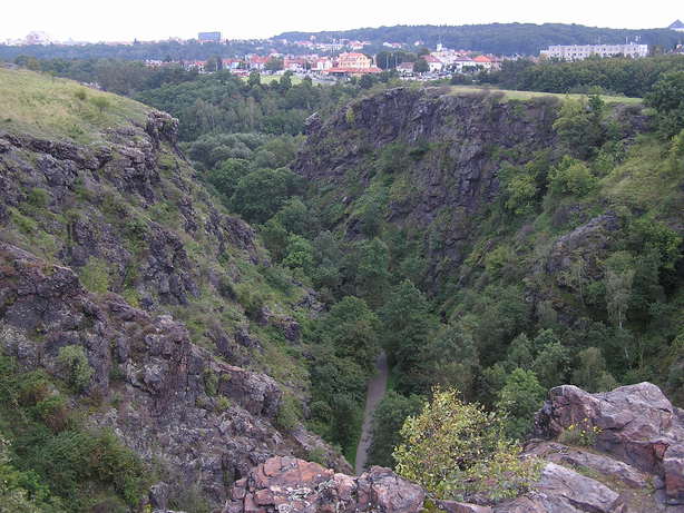
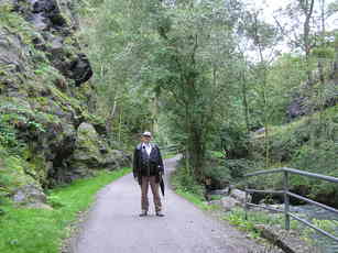
Úvodní souradnice vás zavedou do soutesky Džbán, která je soucástí prírodní rezervace Divoká Šárka. Souteska Džbán je jedním z nejlepších príkladu epigenetického údolí v Cechách.
Prírodní rezervace Divoká Šárka
Prírodní rezervace Divoká Šárka se nachází v Praze 6 na katastrálním území Dolní Liboce a má celkovou rozlohu 25,4 ha. Duvodem ochrany je cenný krajinný celek s hlubokou skalní souteskou v buližnících vytvárející kontrastující mikroklima a s pozustatky valu slovanského hradište zaniklého na prelomu 9. a 10. století na plošinách nad souteskou.
Prírodní rezervace Divoká Šárka patrí k nejstarším chráneným územím v Praze. Toto území je soucasne národní kulturní památkou (stávalo zde slovanské hradište) i archeologickou lokalitou a svým prírodním a historickým významem patrí k nejvýznamnejším lokalitám svého druhu v CR.
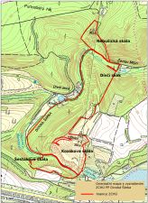
Prírodní rezervace Divoká Šárka je v nejzápadnejší cásti šáreckého údolí. Zaujímá na jihu Šestákovu skálu, pak soutesku Džbánu, k severu pokracující skalní výchozy Kozákovy skály a Dívcího skoku a malý výbežek prekracující Šárecký potok (Nebušická skála). S výjimkou malých lumku u západní paty Dívcího skoku je celé území prírodní rezervace tvorené skalními výchozy buližníku. Celé území prírodní rezervace je vlastne velké, severo-jižne protažené buližníkové teleso proterozoického stárí, které je razeno do kralupsko-zbraslavské skupiny.
Chránené území tvorí asi 2 km dlouhý prulom Šáreckého potoka tvrdými buližníky, vytvárející dve bizarní soutesky, a náhorní plošina nad souteskou. Tyto geomorfologické pomery vytvárejí na skalních stenách s jižní expozicí a na náhorní plošine podmínky pro existenci pozoruhodných spolecenstev teplomilné vegetace skalních stepí. Na stenách se severní expozicí a v inverzní poloze dna údolí naopak vznikla významná chladnomilná rostlinná i živocišná spolecenstva. V krátké nive potoka pod souteskou se zachovaly pekne vyvinuté prirozené meandry.
Výslunné stráne, napr. na Kozákove a Šestákove skále, jsou porostlé teplomilnou (xerotermní) kvetenou, spolecenstvy skalních stepí s koniklecem lucním nacernalým, kavylem Ivanovým a hlavne taricí skalní. Vyskytuje se zde také rada chránených a vzácných druhu lišejníku a játrovek. V údolích nalezneme zbytky prirozených potocních olšin a na severních zastínených skalách rostou cetné vzácné druhy kapradin.
Epigenetické údolí
Z geologického hlediska je nejzajímavejší vznik soutesky Džbánu, jednoho z nejlepších príkladu epigenetického údolí v Cechách. To zacalo behem tretihor vznikat v mekkých horninách svrchní krídy, která byla uložena na proterozoickém podloží. Když se zarízlý potok dostal na úroven tvrdých proterozoických buližníku, nemohl už zmenit svuj smer a musel se do nich dále zarezávat. Podobne vznikla ve stredních Cechách i rada dalších kanonovitých údolí, ve kterých jsou dnes nejlepší geologické profily. Údolí Šáreckého potoka je založené v nejtvrdších horninách pražského území.
Puvod názvu Šárka
Název Šárka pravdepodobne vznikl ze slova šarý neboli šerý, což zrejme charakterizuje šeré šárecké soutesky. Údolí bylo totiž odjakživa díky své hloubce jenom težko prístupné slunecním paprskum. Prímé svetlo se do nej dostávalo pouze v casovém úseku, kdy slunce kulminovalo, jinak zde panovalo a porád panuje šero a chlad.
Archeologická rezervace
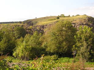
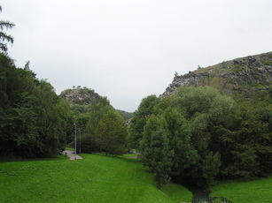
Príkré buližníkové srázy soutesky Džbánu, které jsou tvoreny severní Kozákovou a jižní Šestákovou skálou, skýtaly vhodnou ochranu pro lidské osídlení, které je zde doloženo z ruzných období praveku. Zvlášte významné bylo osídlení v mladší dobe kamenné (v prechodu mezi stredním a mladším neolitem). K charakteristickým nálezum zde patrily zejména krásne zdobené (i malováním) nádoby, podle nichž byl nazván tzv. šárecký stupen (stárí asi 6000 let). Na pravém brehu Šáreckého
potoka se rozkládalo rozsáhlé slovanské hradište, chránené valy a vzkvétající hlavne v 7. a 8. stol. n. l. Hradište bylo významným obchodním strediskem pro pražskou oblast pred vznikem Pražského hradu. Kombinací valu a skal zde bylo vystaveno vnitrní hradisko a dve predhradí. Hradište postupne zaniklo na prelomu 9. a 10. století. Výšiny jsou významnou archeologickou rezervací.
Buližníky
Buližníky jsou velmi pevné horniny, složené hlavne z mikrokrystalických shluku kremene s kolísavým podílem uhlíkaté hmoty, která jim dodává charakteristické tmave šedé zbarvení (místy jsou i svetlejší partie, v blízkosti poruch druhotne cervenave zbarvené oxidy Fe). Buližníky jsou ve velkých mocnostech velmi odolné vuci ohybovým deformacím a pri vrásnení se lámaly a drtily. Proto jsou prostoupeny hustou sítí kremenných žilek a místy mají až brekciovitý ráz. Tektonické porušení, které je z nejvetší cásti již výsledkem kadomského vrásnení, je zdurazneno množstvím vetších puklin a poruch ruzných smeru, casto vyplnených žilným kremenem.
Zajímavá je také skalní stena Nebušické skály, která je názorným príkladem tektonického porušení buližníku nekolika systémy puklin a dislokací.
Buližníky se pred více než 600 miliony lety uložily na dne oceánu, vznikly s nejvetší pravdepodobností okolo výronu horkých pramenu s vysokým obsahem oxidu kremicitého. Vznik proterozoických buližníku dosud není jednoznacne vysvetlen. Vedci se shodují v tom, že k jejich tvorbe prispely hydrotermální, na Si02 bohaté roztoky, provázející v proterozoiku podmorskou vulkanickou cinnost.
Na buližnících z Divoké Šárky byly objeveny zkamenelé pozustatky nejstarších mikroorganismu v Cechách.
Z nedávné historie
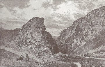
Skalní "brána" soutesky Džbán mela být na pocátku 60. let promenena - preklenuta betonovou skorepinovou cca 15 m vysokou hrází údolní nádrže. A po velkých bojích se podarilo nakonec za pomoci tehdejšího ÚHA hl. m. Prahy a Pražského strediska památkové péce a ochrany prírody (r. 1963) soutesku zachránit a odsunout stavbu hráze dle prvotních investorských zámeru o cca 150 m dále.
Pro zápis platného "cache found" logu:
1) nám poslete e-mailem pres GC-profil odpovedi na následující otázky:
- Jaký je název horniny, která tvorí skalní steny soutesky Džbán. Vyberte z následujících možností: cedic, žula, rula, buližník
- Co se nacházelo na Kozákove skále v 8. stol. n. l.
- V jakém roce byla vyhlášena prírodní rezervace Divoká Šárka. Tento údaj najdete na informacní tabuli na waypointu I1 (nebo I2).
- Jakou nadmorskou výšku ukazuje Vaše GPS v míste úvodních souradnic
2) vyfotte sebe nebo Vaši GPS v míste úvodních souradnic, mezi mostky pres Šárecký potok, viz spoiler, fotku priložte k logu.
Necekejte na schválení logu, mužete zalogovat "found" a poslat odpovedi, provedeme následne kontrolu a pokud neco nebude v porádku, ozveme se...
Prístup ke kešce
Nenechte si ujít výhled od parkovište u Mc Donaldu od waypointu V1, je odtud pekný pohled na soutesku Džbán s Šestákovou skálou v popredí a Kozákovou skálou za ní. Do soutesky k úvodním souradnicím se dostanete po cervené turistické znacce. Cestou u waypointu I1 budete míjet informacní ceduli Divoká Šárka, stejnou informacní ceduli najdete na waypointu I2 na západním okraji soutesky Džbán.
Skvelý výhled do soutesky Džbán je zhora z Kozákovy skály, tato návšteva je nepovinná, doporucujeme dojít na waypoint V2, potom pocítejte s terénem 2,5*, od hráze vodní nádrže Džbán vede na Kozákovu skálu cervená turistická znacka. Nechodte prosim Vas na tuto vyhlidku na Kozakove skale (na waypoint V2) "primo za sipkou" od uvodnich souradnic earthcache! Jste v prirodni rezervaci, lezeni po skalach je tu zakazano! Muzete si na skalach v okoli vsimnout zakazovych horolezeckych znacek, obsahujicich krizky (x). Nahoru na Kozakovu skalu vede od hraze cervena turisticka znacka az k waypointu OK (Turning / odbocka). Vezte, ze kvuli nezodpovednym kacerum kteri lezli nahoru primo ze soutesky byla jiz v techto mistech archivovana keska GCNAN8.
Doprava
MHD:
Ze stanice metra A Dejvická na zastávku Divoká Šárka: Bus 119, 218, tramvaje 20, 26.
Parkování:
P1 - parkovište u McDonaldu (placené 40,-/hod, 1. hodina zdarma) N 50° 05.585 E 014° 19.337
P2 - u hrbitova zdarma N 50° 05.571 E 014° 19.630
Slovnícek pojmu
proterozoikum= starohory - stárí 2500 - 542 milionu let
prvohory= paleozoikum - stárí 542 - 251 milionu let
druhohory = mezozoikum - stárí 251 - 65,5 milionu let
tretihory = terciér - stárí 65,5 - 2,5 milionu let
ctvrtohory = kvartér - stárí 2,5 milionu let až dodnes
krída - útvar druhohor, stárí 145,5 - 65,5 milionu let
šárecký stupen - období 5100 - 4900 let pr. n. l. z mladší doby kamenné (neolitu)
epigenetický - z reckého epigenetikos = vznikající na puvodním míste
epigeneze - v geomorfologii prohloubení koryta vodního toku bez ohledu na strukturu a složení skalního podkladu. Vzniká v prípadech, kdy bylo puvodní koryto založeno v horninách jiného charakteru, obvykle mekcích, než je hlubší skalní podklad.
brekcie - hornina tvorená stmelením ostrohranných úlomku jiných hornin pri tektonických ci sedimentárních procesech
kadomské vrásnení - horotvorný pochod na konci proterozoika a na pocátku paleozoika (= assyntské neboli panafrické vrásnení)
silicity - kremité horniny, patrí mezi ne buližníky
ÚHA - Útvar hlavního architekta
Podekování
Dekujeme geokamarádovi jarda3066 za korektury anglické cásti listingu.
V galerii najdete následující obrázky v lepším rozlišení / In the gallery you can find the following pictures in better resolution
[EN]
The initial coordinates takes you in the Džbán gorge. This gorge is a part of the Divoká Šárka Nature Reserve. The Džbán gorge is one of the best examples of superimposed valley inside the Czech Republic.
The Nature Reserve Divoká Šárka
The Nature Reserve Divoká Šárka is situated within the cadastral territory of Dolní Liboc in the Prague 6. Its total extent is 25,4 ha. The valuable scenic unit with the deep gorge in lydites forming the contrasting microclimate and relics of the Slavic settlement destroyed at the turn of the 10th century are arguments for its protection.
The Nature Reserve Divoká Šárka belongs to the oldest protected territories in Prague. This terrain is the natural cultural monument because of the former Slavic settlement. There is also an archaeological locality here and this place belongs to the most significant localities of its kind in the Czech Republic because of its natural and historical importance.
The Nature Reserve Divoká Šárka is located in the westmost part of Šárka Valley. It contains Šesták Rock on the south, then Džbán gorge, then the outcrops of the Kozák Rock and of the Dívcí Skok (Girl's Jump) following to the north, and then small ness at the opposite side of the Šárka brook (Nebušice Rock). The entire area of the nature reserve consists of the rock outcrops of the lydites, with the exception of the small quarry at the west bottom of the Dívcí Skok. The area of the Nature Reserve is the large, southnorthern elongated proterozoic solid of lydite of the Kralupy-Zbraslav Group.
The protected area consists of about 2 km long hard lydite breakthrough of the Šárka brook, which forms two bizarre gorges, and the plateau above the gorge. These geomorphological terms create the conditions for the existence of remarkable communities of thermophilous rocky steppe vegetation on the rock walls with southern exposure and on the plateau. On the contrary, on the walls with northern exposure and in the inverse position of the valley floor grew a significant psychrophilous plant and animal communities. Well developed natural meanders were preserved in the short floodplain of the stream below the gorge.
The sun-exposed hillsides of the Kozák Rock and of the Šesták Rock are covered with thermophilous (xerothermophilous) vegetation, rocky steppe communities with Pulsatilla pratensis subsp. Nigricans, Stipa pennata (Feather Grass) and mainly Aurinia saxatilis. There is also a number of protected and rare species of lichens and liverworts (Marchantiophyta). In the valleys we find remnants of native brook alder woods and on the northern shaded rocks grow many rare species of ferns.
Superimposed valley
The formation of the Džbán gorge is the most interesting from the geological point of view. It is one of the best examples of superimposed valley within the Czech Republic. This gorge began forming in Tertiary in the soft Upper Cretaceous rocks, which overlaid the Proterozoic basement. The streem had carved out the valley, and when it had reached the level of hard Proterozoic lydites, it could not change its course and had to dig in deeper. Many other canyon valleys, in which there are the best geological profiles today similarly originated in central Bohemia. Šárka Brook Valley is based on the hardest rocks of the Prague area.
Origin of name Šárka
The name "Šárka" probably originated from the word "šarý", from which it was created today's word "šerý" (shadowy in english). This apparently characterizes the dim gorges in the Šárka Valley. The valley was always hardly accessible to sunlight due to its depth. Direct light gets to the valley only during the time period when the sun culminates, otherwise, there is dark and cold there.
Archeological reserve
Steep lydite cliffs of the Džbán gorge which are formed by northern Kozák Rock and southern Šesták Rock, provided adequate protection for human settlements which is documented there from various periods of prehistory. The settlement of the New Stone Age (Neolithic), in the transition between the Middle and Late Neolithic was particularly significant. The characteristic findings here were particularly beautifully decorated (also by painting) bins, which gave the name to Šárka Phase (age about 6,000 years). A large Slavic settlement protected by mounds was situated on the right bank of the Šárka Brook. It flourished mainly in the 7th and 8th century A.D. The settlement was important trade centre for Prague area before establishment of the Prague Castle. Combining the mounds with the rocks there was built an inner fortified settlement with two settlements around. The Slavic settlement successively died out at the turn of the 10th century. The tablelands are the important archeological reserve.
Lydites
Lydites are very firm rocks composed especially from the microcrystalline burks of the quartz with variable ratio of the carbonaceous matter, which caused characteristic dark-grey colouring (lighter areas are also here and there, in the proximity of the faults secondarily red coloured oxides of iron). Lydites are very resistant to flexion strains when in the big thickness, and they break and crush during the folding. That is why they are penetrated by dense net quartz veins and have brecciated character here and there. Tectonic rupture, which is in most part the result of the Cadomian folding, is emphasized by amount of fissures and dislocation of various directions, frequent filled by vein quartz.
Rock wall of the Nebušice Rock is also interesting, it is illustration of the tectonic rupture of lydites by several systems of fissures and dislocations.
Lydites deposited on the sea bottom more than 600 milions years ago, they originated in all likelihood around outburst of hot springs with hight content of silicon dioxide. Origin of the proterozoic lydites is not unambiguously clarified. Scientists coincide in the theory, that hydrothermal solutions rich in Si02 contributed to formation of lydites, they accompanied the submarine volcanic activity.
Fossilized remains of oldest micro-organisms in the Bohemia were detected on the lydites in Divoká Šárka.
From the recent history
Rock gate of Džbán gorge should be changed at the beginning of sixties, it should be arched over by about 15 metres hight concrete shell dam of impounding reservoir. After great fights ÚHA of Prague and Prague conservation and nature protection centre managed to preserve the gorge and to shift the construction of the dam according to first developer plan by 150 metres further (in 1963).
The way to valid "cache found" log:
1) send us answers to following questions by e-mail using GC-profile:
- What is the name of the rock, which forms the rock wall of the Džbán gorge. Select from the following possibilities: basalt, granite, gneiss, lydite
- What was located on the Kozák Rock in the 8th century A.D.
- What is the year of the declaration of Nature Reserve Divoká Šárka. You can find this information at the information table at the waypoint I1 (or I2).
- What is the altitude showed on your GPS at the initial coordinates
2) Take a photo of you or your GPS at the initial coordinates, between the bridges over Šárka brook, see spoiler, and upload this photo to your log.
Do not wait for our confirmation, you can log found and send us the answers. We will check your solution, if it will contain errors, we will email to you ...
Access to the cache
Dont miss the view from the parkingplace near Mc Donald from the waypoint V1. You have a nice view of the Džbán gorge with the Šesták Rock in front and the Kozák Rock in the rear from here. You can reach the gorge at the initial coordinates following the red tourist mark. You will pass by the information table Divoká Šárka on your way near waypoint I1. You will find the same table on the waypoint I2 at the western margin of the Džbán gorge.
It is a nice view from above the Kozák Rock into the Džbán gorge. The visit of this place is optional. If you decide to do this visit, we recommend you to go beyond the waypoint V2. You can expect the terrain 2,5* here. The red tourist mark leads you from dam of the water basin Džbán to the Kozák Rock.
Transport
Public transport:
From the station Dejvicka of the subway line A to the station Divoká Šárka: Bus 119, 218, tram 20, 26
Parking:
P1 - parking area by Mc Donald (fee 40,- Kc/hour, 1. hour free)
P2 - free parking place by cemetery
Dictionary
Proterozoic - 2500 - 542 million years ago
Paleozoic - 542 - 251 million years ago
Mesozoic - 251 - 65.5 million years ago
Tertiary - 65.5 - 2.5 million years ago
Quaternary - 2.5 - 0 million years ago
Cretaceous - 145.5 - 65.5 million years ago
Šárka Phase - period 5100 - 4900 BC of New Stone Age (Neolithic)
epigenetic - from Greek epigenetikos = originating on the original place
superimposition - in geomorphology, forming of the water course of the current of water without regard to the structure and composition of the rock basement. It results in the case, when original flume is founded in the rocks of different type, usually softener than it is the deeper rock basement. Superimposed valleys result from the activity of rivers that had carved out their original valley in rocks of an earlier structural stage that were subsequently partially or completely eroded away. When the river cuts deeper into the rocks of the lower structural stage, the valley retains its initial direction, becoming a superimposed, or epigenetic, valley.
breccia - is a rock composed of broken fragments of minerals or rock cemented together, it is formed in the tectonic and sedimentary processes.
Cadomian folding - orogenic process at the ending of Proterozoic and at the beginning of Paleozoic
silicites - siliceous rock, lydites belongs to silicites
ÚHA - department of the head architect
Acknowledgements
Many thanks to geofriend jarda3066 for the correction of the English part of the listing.
Literatura / References
- Jirí Kríž, Geologické památky Prahy, Ceský geologický ústav, Praha, 1999.
- Ivo Chlupác, Vycházky za geologickou minulostí Prahy a okolí, Academia, Praha, 1999.
- Q. Záruba, J. Vachtl, M. Pokorný, Základy geologie a petrografie pro stavební fakulty, SNTL, Praha, 1974.
- Prírodní rezervace Divoká Šárka, http://envis.praha-mesto.cz/rocenky/chruzemi/cr2_cztx/CHU13.htm
- PR Divoká Šárka, http://envis.praha-mesto.cz/zdroj.aspx?typ=2&Id=1550&sh=352678072
- Divoká Šárka, http://envis.praha-mesto.cz/zdroj.aspx?typ=2&Id=83654&sh=-554431940
- Prírodní park Šárka - Lysolaje, http://envis.praha-mesto.cz/zdroj.aspx?typ=2&Id=84616&sh=447991143
- PR Divoká Šárka - orientacní mapa, http://envis.praha-mesto.cz/planypece_ozchu/PR_Divoka_Sarka_2010_2024/PR_Divoka_Sarka_orient_mapa.jpg
- Divoká Šárka Nature Reserve, http://envis.praha-mesto.cz/rocenky/CHRUZEMI/cr2_antx/chu13.htm
- Šárka Valley, http://envis.praha-mesto.cz/rocenky/CHRUZEMI/cr2_antx/chu-sark.htm
- PR Divoká Šárka, CGS, http://www.geology.cz/app/glok/glok_cz.pl?id_=205&tt_=z
- NR Divoká Šárka, CGS, eng., http://www.geology.cz/app/glok/glok_an.pl?id_=205&tt_=z
- International Stratigraphic Chart 2009, http://www.stratigraphy.org/upload/ISChart2009.pdf
- Brevnovan, rocník 19, 1/2, 2008, http://files.brevnovan.net/200000018-a9e0daadab/Brev0801.pdf
- Šárecké údolí vydalo ztracenou studánku, Praha 6, aktuality, 2005 http://www.praha6.cz/aktuality/aktualita.php?ID=660
|