On your walk from parking to the river, you will see examples of
erosion caused by the North Fork of the Stillaguamish River, and in
one spot man’s attempt to tame the river from eroding its bank.
Have you ever seen the perfect skipping stone? Or the small
swimming pools to the side of a river? All of these things plus
many more are all products of erosion.
Park at the coordinates, inside the section separated by the
barbed wire. Follow the mowed path through the opening to the right
of the caretakers house, through the field to the river access.
River erosion is the gradual removal of rock material from the
river banks and bed.
A river causes erosion in the following ways:
Corrasion (abrasion): - The river uses its load to grind
against the bed and sides. The action would dislodge the materials
and carry them away. This process operates in 2 ways
(verticle--> depth; lateral--> width). Potholes are the
product of corrosion

Attrition: The loosened materials that are being carried
away collide against the river sides and bed and against one
another. Over time, they would become smaller and eventually
reduced to fine particles called silt
Solution (corrosion): - The solvent action of water
dissolves soluble materials and carry them away in solution.
Hydraulic action: - The breaking down of rocks. Removing
and dragging rocks from the bed and banks of the river by the force
of the running water (like a water jet). Usually there are lines of
weakness like joints and cracks in the river. The work of hydraulic
action forms plunge pools (small lakes).
Resulting Erosion Features:
Potholes: Circular depressions on the river bed. Formed
by corrosion (abrasion) Most effective in flood conditions. Pebbles
which are trapped in hollows on the river bed are swirled about in
turbulent/ fast flowing water
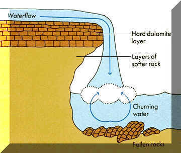
Plunge pools: A large depression at the foot of a
waterfall. This depression is deepened by hydraulic action of the
plunging water. Condition: likely to form when the water plunges
into less resistant rocks. It may be further enlarged by rock
debris swirling about by turbulent water at the base.
Rapids: A series of very short and fast falls. Condition:
an area of alternating bands of resistant and less resistant
rocks
Waterfalls: - Vertical flows of fast moving water flowing
from great heights Formed by 2 ways: - Due to unequal resistance of
rocks or faulting. Unequal resistance- less resistant rocks are
eroded more rapidly than resistant rocks. As a result, there is a
change in gradient By faulting- displacement of rocks results in a
difference in height between 2 rocks, water plunges downwards
Gorges: Valleys which are steep sided, deep and narrow.
The churning water at the base of the falls eats away the soft
underlying rock layers of the gorge. The unsupported hard top rock
then breaks off.
In my research I have discovered that this area is quite
possibly the location of an old Indian Longhouse.
“On the banks of the Stillaguamish River (Sugwalitch) near the
present Trafton, stood at one time a big Indian house. The Still
chief had decided to hold a Potlatch or Squee-quee. A large
attendance was expected, greater than the smaller buildings could
house, so a larger building was erected. When completed it was a
very fine building. About 40 years ago, during a talk with Jimmy
Dorsey, then Stillaguamish Chief, he gave me some particulars about
it. About 30 paces long, 6 paces wide; heavy posts, plates and
beams, long-split and hewed cedar boards for siding and roof. The
roof overlapping so the smoke could go out and rain couldn’t come
in, long fire pits in center of a dirt floor, bunks for beds and
seating along the walls. Pictures carved and painted on wood hung
on the walls. White men who saw this building while it was still
standing said it was a well built house. Jimmie Dorsey said it had
only one door-a large opening in the middle front. The squee-sqee
was held. At the time white man’s food could be bought, and the
Indians had acquired a taste for Boston Muckamuck, great amounts of
flour, sugar and beans had been provided. The affair lasted a week
day and night. Many valuable gifts were distributed. There was
dancing, singing and talks-and no serious trouble” Indian
Stories and Legends of the Stillaguamish, Sauks and Allied Tribes,
Nels Bruseth 1950
To log this Earthcache you must with your online log post
pictures of the following:
• The untreated cedar logs standing straight up in the ground
that are used to prevent the Stillaguamish from eroding its banks,
and the erosion that happened where the cedar logs stopped. (see
Sassy's log for an example)
• 3 different examples (not including the cedar logs or the
result of where they stopped placing them) of how the river is
currently causing, or the effects of erosion. In the picture title
name the erosion cause or effect you are posting a picture of.
Some of the features listed in the description may not be
present at this location.
Others may depend on if you come during high or low water flow
times.
The holes across the bank of the Stilly are not cause by
erosion. They are river otter holes and won’t be counted towards
the logging requirements.
There are a total 4 pictures required, you are more than welcome
to post more!
Earthcaches have a unique set of guidelines for the cache
write up, and logging that must be met. Most importantly have
fun!!