Sulfide Caves
in Devil’s Hopyard:
Karst features?
The Devil’s Hopyard State Park is underlain by
rocks of the Brimfield Formation. The Brimfield Formation is
made up of schist and gneiss that contain significant amounts of
sulfide minerals1, notably iron-sulfides such as
pyrite and pyrrhotite. When pyrite is exposed to water
containing dissolved oxygen it weathers according to a chemical
reaction2 and forms rust (iron-oxide minerals
limonite, hematite, or goethite) and sulfuric acid. The rock
is rendered weaker because the space where the pyrite formerly
resided becomes a hole in the rock. Sulfuric acid then
dissolves other constituents of the rock, further weakening the
rock. Precipitition of iron-oxide minerals renders the rocks rusty
and rocks of the Brimfield Formation are notorious for their
rusty-weathering. This EarthCache explores some examples of
cave formation associated with sulfide weathering of the Brimfield
Formation at the Devil’s Hopyard State Park3.


Location: East Haddam, CT
N. 41o28.640’, -072o26.887’
Listed by: CTGeosurvey
Directions: To get there, follow
highway signs on Rte. 82 to the Devil’s Hopyard State Park and take
the orange trail4 south. You will find two
parking areas. We suggest you park in the upper parking area
near Chapman Falls rather than the lower parking area near the
picnic grounds. That is because of another EarthCache located
at the Falls5 and because you will pass an
example of sulfidic weathering (Figure 1).
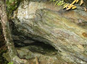
Follow the trail along the west side of the
waterfall to a bridge where it crosses a tributary to Eightmile
River. Along the tributary stream just south of N.
41o29.040’, -072o20.549’ there is a large
overhang on the valley wall that resulted from the erosion of a
presumably sulfide rich layer. Solution of the sulfide
minerals and creation of sulfuric acid rendered the rock
susceptible to erosion by groundwater seepage. That is,
ground water seeping from the rocks actually eroded the rock one
grain at a time.
Figure
1. Small cave in an overhang on the valley wall of a
tributary to Eightmile Brook near Chapman Falls. (Tree trunk is
about 6” in diameter for scale)
Several other factors may also have
contributed to this erosion, such as rainwater and ice
wedging) of individual
grains. It is also possible that the stream was at this level
during cave formation, as it had not eroded its canyon down to its
present level. If this was the case, then running water from the
stream would also have contributed to the erosion. The
resulting large overhang now extends into the rock 4 or 5
feet. It is a small cave!
 Continue down the trail past some rusty
outcrops and eventually to a picnic area where you will find a
covered bridge that takes you to the orange blazed trail.
Follow the orange trail south to a point due west of the given
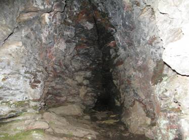
location. A trail goes steeply uphill to the Devil’s Oven
which is a small cave developed along a fracture in sulfidic schist
and gneiss (Figures 2a and 2b). It is approximately three
feet wide and extends into the cliff about 20 feet, becoming
progressively narrower. The cave is sort of tear-drop shaped
in cross section. Limestone caves often have this shape
because of formation at a water table surface sometime in the
past. It is possible that the Devil’s Oven also records the
elevation of a former stream level or water table at a time when
the valley was not as deep as it is today.
Continue down the trail past some rusty
outcrops and eventually to a picnic area where you will find a
covered bridge that takes you to the orange blazed trail.
Follow the orange trail south to a point due west of the given
location. A trail goes steeply uphill to the Devil’s Oven
which is a small cave developed along a fracture in sulfidic schist
and gneiss (Figures 2a and 2b). It is approximately three
feet wide and extends into the cliff about 20 feet, becoming
progressively narrower. The cave is sort of tear-drop shaped
in cross section. Limestone caves often have this shape
because of formation at a water table surface sometime in the
past. It is possible that the Devil’s Oven also records the
elevation of a former stream level or water table at a time when
the valley was not as deep as it is today.
2a.
2b.
Figure
2a. The Devil’s Oven, a cave developed along a fracture in sulfidic
schist and gneiss. Cave is about three feet wide.
2b. Looking into the cave.
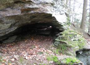
If you follow the trail around to the left
(north) you will come to additional small caves, one of which is
illustrated in Figure 3. This is a tunnel like cave formed in
the same rock formation as the Devil’s Oven. This, however,
did not form along a fracture and as a result is not very
high. It is a long tunnel that has a small window (perhaps a
chimney?) at its end. This cave is about 25 feet long. Most
of the caves are found at a similar elevation (~250’).
Possibly all the caves formed at the same time when groundwater was
more acidic and/or more oxidizing. For the groundwater to be
at this elevation the valley must not have been as deep as it is
today.
Figure
3. Small cave north of Devil’s Oven. Cave is about 3
feet high at opening. Note light inside the cave: that
is a small window at rear of cave. This cave is a
tunnel.
Study the topographic map (Figure 4) and
notice that the upland surface on both sides of the Eightmile river
canyon is roughly about 450+’ in elevation. The canyon is
around 250 deep. The sides of the canyon contain areas with
somewhat hummocky topography. See particularly the west side
between Chapman Falls and the tributary brook near the southern
park boundary.
In addition a couple of areas have closed
topographic contours (notably just west of Foxtown Road , see
magenta circle on Fig. 4). These features are similar to what
is found, on a much larger scale, in karst topography. Karst
topography develops on limestone or marble, rocks that are
relatively soluble in acidic groundwater. The features at
Devil’s Hopyard are much more subtle, but we maintain the
topography at Devil’s Hopyard was formed by similar
processes. The sulfidic schist is not as soluble as limestone
or marble and hence the topographic features are more subdued.

Figure 4. Topographic map of Devil’s Hopyard State Park and
surrounding areas. Contour interval is 10 feet. Solid
magenta dot marks location of Devil’s Oven.
If you return to the orange blazed trail and
continue a short distance south you will be rewarded by a
magnificent vista in which “a long stretch of the river is
visible,” (Leary, 2004, p. 66-67.)
1. Sulfide minerals contain
metal cations such as iron or lead or copper and sulfur.
2.
Pyrite + water + oxygen
à
iron oxides + sulfuric acid + ion
3. To
learn more about the geology of the area, go to the Connecticut
Department of Environmental Protection
website
The Geology of Devil’s Hopyard State Park .
4. See
Devil’s Hopyard State Park Trail Map
5. See
EarthCache titled
“
Devil’s Hopyard State Park: Footprints of the
devil?”
How to get credit for this cache:
- Notice that we forgot to include a
scale for Figure 2a or 2b so the reader cannot tell the size of the
Devil’s Oven. Submit a picture of you and/or your companions
posed at the mouth of the Devil’s Oven so we can see just how large
the opening is.
- Measure the width of the Devil’s Oven and
submit that information with your picture.
Difficulty: 1
Trail difficulty: 3.5 (very steep slopes
around Devil’s Oven).
References:
Leary, Joseph, 2004, A Shared Landscape: A
Guide and History of Connecticut’s State Parks
and
Forests. Friends of Connecticut State Parks, CT D.E.P,
and CT Forest and Park Association, Hartford, CT, 240p.
Stone, J.R., Schafer, J.P., London, E.H.,
DiGiacomo-Cohen, M.L., Lewis, R.S., and
Thompson, W.B., 2005,
Quaternary Geologic Map of Connecticut and Long Island Sound Basin
(1:125,000). U.S. Geol. Surv. Sci. Invest. Map # 2784.