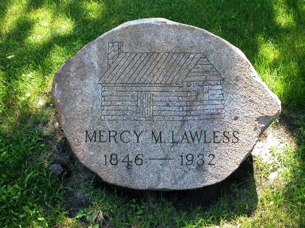
This is a “pictocache” that will require you to find
various objects in pictures and match them up with a numbered list
of coordinates. The coordinates are sometimes off by a block, on
purpose. It’s like multiple choice. Just choose the best one.
Once you get the list of coordinate numbers in place you will use
them to determine the coordinate of a small strip of aluminum
attached to the backside of an object. The engraved numbers should
be enough for you to get to the cache. Drive to the dead-end and
walk in. Cut through the valley.
First of all I want to say that I named this "My Waterloo"
because I like to think of it as promoting Waterloo in some small
way, like "My Waterloo Days" does in a big way.
All the images listed below were taken in the city of Waterloo,
Iowa. Only a few of the coords are very near the object however.
That means that you will often have to drive around a bit to find
the object in the image. The coords of some of the easy to spot
things are off by a couple blocks. All but one object is visible
without getting out of the car; the coord for that one is close.
Once you complete the exercise of matching a best coord with an
object you’ll have to use the order of the numbered
coords to calculate the position of a little piece of aluminum with
the coordinate for the cache engraved into it. All the images
represent interesting attributes of this fine city where I have
lived for more than half a century. 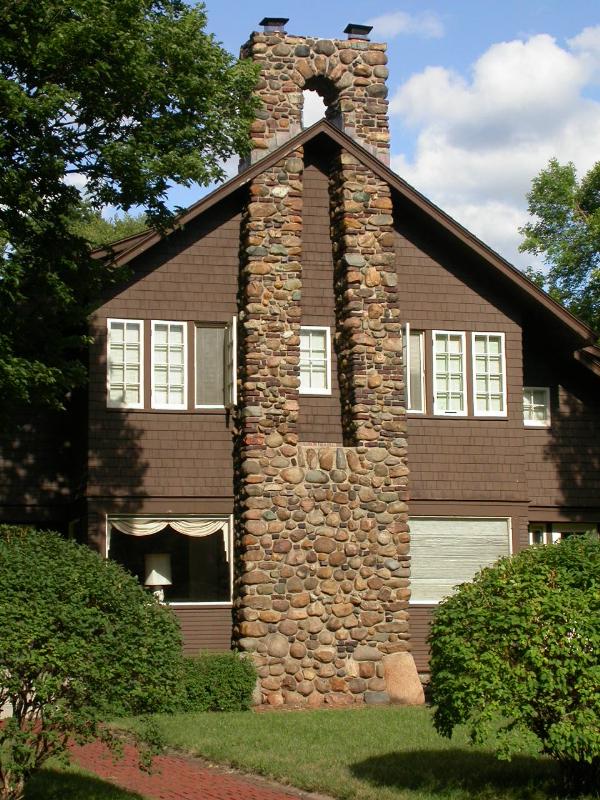
Matching ONE object with ONE NEAREST coord is critical. Two of
the coords AND one of the images are “distracters”
(i.e. bogus). The two distracter coords are not as close to any of
the “good” images as is another coord. If you happen to
find the one distracter image you will notice that it is not as
close to any coord as another object is. That gives it away as the
distracter. No coord that’s not used will be at all close to
it.
Once you find everything you need to find you should have a list
of coord numbers. For example, if the first three image/coord pairs
are, Image 1 = coord 10, image 2 = coord 3, and image 3 = coord 8,
you should have written 10, 3, and 8 so far.
Now to obtain the coord for the 1st cache add together the first
10 of the 16 rearranged coord designations and add the last 6
together then subtract the sum of the last 6 from the sum of the
first 10. Divide the answer by 100 and add the result to both the
incorrect lat and long here: 42 29.436 by 92 21.711 to get the
correct lat and long for the 1st cache.
You can check your answer to this cache on
Geochecker.com. This URL for
terraserver viewer shows the position of all the waymarks that
you will need to check out!
The cache is a small camouflaged Lock-n-Lock container on the
ground. NOTE! So that you may get good reception near the cache I
made it so the cache is a number of feet directly east of the
coordinates engraved on the metal. The coordinates are for a spot
out in the open. I left the cache on the edge of the woods.
NOTE: If printing off the gallery page is not sharp enough you
may want to copy and paste each of the pictures onto a Word
document and shrink them down to fit several on a page before
printing them to take along with you. ALSO, I UPLOADED THE IMAGES
FROM LAST TO FIRST, AS I HAVE ALWAYS DONE. I CANNOT TAKE CREDIT FOR
THE FACT THAT THEY ARE OUT OF SEQUENCE! AT LEAST THEY ARE CORRECTLY
ORDERED IN THE GALLERY.
Below is the list of the coords to consider when completing this
exercise. [Remember, two are not the best choice for any of the
images!] You don't have to enter them into a GPSr. Just take a copy
of the list with you and watch to see them come up as you drive
around. Make sure not to get in a wreck! We don't want to have
people equating geocaching while driving with cell phone use while
driving!
The Coordinates by
Number
| Coordinate |
Latitude |
Longitude |
| Coord 1 |
42 28.255 |
92 21.417 |
| Coord 2 |
42 28.167 |
92 20.658 |
| Coord 3 |
42 28.339 |
92 22.306 |
| Coord 4 |
42 28.239 |
92 22.028 |
| Coord 5 |
42 28.658 |
92 21.866 |
| Coord 6 |
42 28.966 |
92 21.929 |
| Coord 7 |
42 28.986 |
92 21.483 |
| Coord 8 |
42 29.456 |
92 20.634 |
| Coord 9 |
42 29.473 |
92 21.380 |
| Coord 10 |
42 29.670 |
92 22.032 |
| Coord 11 |
42 29.710 |
92 20.840 |
| Coord 12 |
42 30.050 |
92 20.191 |
| Coord 13 |
42 30.150 |
92 22.326 |
| Coord 14 |
42 29.991 |
92 18.721 |
| Coord 15 |
42 30.233 |
92 23.957 |
| Coord 16 |
42 30.577 |
92 20.994 |
| Coord 17 |
42 30.777 |
92 20.264 |
| Coord 18 |
42 31.001 |
92 20.591 |
In the final cache I initially placed two waterproof match
containers (great for microcaches), a Stick-em Ball, a No Spill oil
spout, two fishing bobbers, Kids Scissors and my travel bugs Tigler
the Wigler and Wacky Fender. Good luck and enjoy My Waterloo!