Gap in Time- A Profound Unconformity EarthCache
Gap in Time- A Profound Unconformity
-
Difficulty:
-

-
Terrain:
-
Size:  (not chosen)
Please note Use of geocaching.com services is subject to the terms and conditions
in our disclaimer.
This series of earth caches is based on the publication “Roadside
Geology Along the Alexandria to Ashland (AA) Highway.” The road
logs were published by the Kentucky Geological Survey to give the
public an appreciation of the geologic world around them.
Many geologists have referred to the AA Highway as a “treasure
trove” and “an outdoor classroom” in which to study diverse and
significant geologic features. Buckle your seat belts and head back
in time. Each cache in this series will stop at a unique geologic
formation and will seek answers to some basic questions that should
be easy to calculate. Sizeable pull off areas are available at each
stop in the series. Geology students frequent the locations
routinely. The calculations can be made from your car even, making
it handicap accessible!
Much of Earth appears fixed and unchanging when viewed through the
lens of human experience. However, as we look more closely at the
components of the Earth system we can recognize changes that occur
on a variety of time scales. Geologic processes that occur over
time intervals measured in minutes to decades typically operate on
a local or regional scale and can often be observed directly. The
methods we use to measure time on a daily basis are useless for
delving into the history of Earth. Rather than measuring time in
minutes or years, geologists use techniques that enable them to
measure rocks that are millions of years old. Once described, even
novice geologists can apply these rules to unravel the geologic
history of the rocks below their feet.
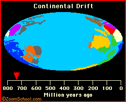
The Earth is very old -- 4.5 billion years or more -- according to
recent estimates. This vast span of time, called geologic time by
earth scientists, is difficult to comprehend in the familiar time
units of months and years, or even centuries. How then do
scientists reckon geologic time, and why do they believe the Earth
is so old? A great part of the secret of the Earth's age is locked
up in its rocks, and our centuries-old search for the key led to
the beginning and nourished the growth of geologic science.
The evidence for an ancient Earth is concealed in the rocks that
form the Earth's crust and surface. The rocks are not all the same
age -- or even nearly so -- but, like the pages in a long and
complicated history, they record the Earth shaping events and life
of the past. The record, however, is incomplete. Many pages,
especially in the early parts, are missing and many others are
tattered, torn, and difficult to decipher. But enough of the pages
are preserved to reward the reader with accounts of astounding
episodes which certify that the Earth is billions of years old.
Across Kentucky, natural outcrops and man-made excavations have
exposed layers of rock strata. To a geologist, these layers are
like the pages in a book, and each tells a part of the geologic
story. Geologists can determine the relative age of sedimentary
rock layers from the fossils they contain. Similar layers can be
grouped into units of rock or strata, just as pages are combined
into chapters in a book.
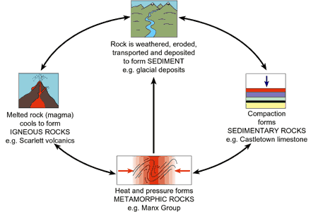
Careful studies by scientists showed that rocks had diverse
origins. Some rock layers, containing clearly identifiable fossil
remains of fish and other forms of aquatic animal and plant life,
originally formed in the ocean. Other layers, consisting of sand
grains winnowed clean by the pounding surf, obviously formed as
beach deposits that marked the shorelines of ancient seas. Certain
layers are in the form of sand bars and gravel banks -- rock debris
spread over the land by streams. Some rocks were once lava flows or
beds of cinders and ash thrown out of ancient volcanoes; others are
portions of large masses of once molten rock that cooled very
slowly far beneath the Earth's surface. Other rocks were so
transformed by heat and pressure during the heaving and buckling of
the Earth's crust in periods of mountain building that their
original features were obliterated.
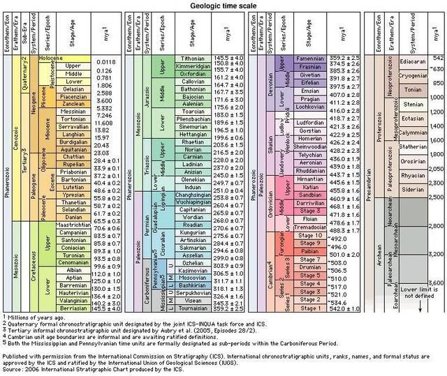
Two scales are used to date these episodes and to measure the age
of the Earth: a relative time scale, based on the sequence of
layering of the rocks and the evolution of life, and the
radiometric time scale, based on the natural radioactivity of
chemical elements in some of the rocks.
In order to determine the relative age of rock layers, scientists
use simple principles. The Principle of Superposition is a logical
and obvious principle that is applied to sedimentary rocks. Layers
of sediments are usually deposited in succession in horizontal
layers, which later are compacted and cemented into layers of
sedimentary rock. An undisturbed sequence of horizontal layers is
thus arranged in chronological order with the oldest layers at the
bottom. Each consecutive layer will be younger than the one below
it, with the understanding that the layers have not been turned
over by deforming forces. The Principle of Cross Cutting
Relationships states that any feature or structure that cuts
through and disturbs a rock sequence must be younger than the
disturbed beds.
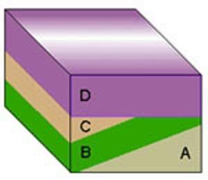
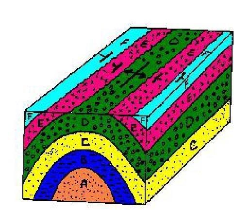
Superposition: A lies below B so A must be the oldest unit.
Original horizontality: A, B, and C must have been deposited as
horizontal layers. Because they have the same orientation we can
probably consider them a discrete group that experienced a similar
geologic history.

Original horizontality: Because A, B, and C are more steeply tilted
than the overlying units they must have been uplifted and tilted
early in the history of the region.
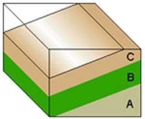
Superposition: D must have been deposited after C as it overlies B
and C. Original horizontality: D was deposited as a horizontal bed.
Cross-cutting: D must be younger than B and C because it cuts
across the underlying layers.
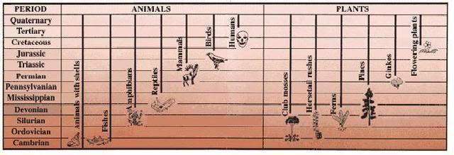
Fossil Succession deals with fossils in sedimentary rock. Careful
mapping around the world has revealed that rock of certain ages
contains distinctive combinations of fossils. If we begin at the
present and examine older and older layers of rock, we will come to
a level where no fossils of humans are present. If we continue
backwards in time, we will successively come to levels where no
fossils of flowering plants are present, no birds, no mammals, no
reptiles, no four-footed vertebrates, no land plants, no fishes, no
shells, and no animals. The three concepts are summarized in the
general principle called the Law of Fossil Succession: The kinds of
animals and plants found as fossils change through time. When we
find the same kinds of fossils in rocks from different places, we
know that the rocks are the same age. Scientists use the fossils of
animals to help determine relative age. Certain groups of fossil
animals and plants occur in the geologic record in a specific
order. If a scientist finds one of those fossils they can then
assume the age of the rock based on the age of the fossil.
There are two basic types of contacts between rock units,
conformable and unconformable. Conformable contacts between beds of
sedimentary rocks may be either abrupt or gradational. Most abrupt
contacts are bedding planes resulting from sudden minor changes in
depositional conditions. Gradational contacts represent more
gradual changes in depositional conditions. Conformable contacts
indicate that no significant time gap or break in deposition has
occurred. Unconformable contacts are surfaces which represents a
gap in the geologic record.

Rock layers can be thought of as pages in a history book that was
written backwards with the most current events in the front and the
most ancient history in the back. However, various geologic forces
can disrupt rock sequence chronology. When erosion removes layers
near the surface, and later in time more layers are deposited over
the exposed rock, an entire time period ends up missing from the
sequence. A time break in the rock record is called an
unconformity. The unconformity is usually shown by a surface within
a sedimentary sequence on which there was a lack of sediment
deposition, or where active erosion may even have occurred for some
period of time. Sometimes, one or more rock units are missing from
the middle of a sequence. Close examination of the outcrop shows a
sharp or irregular contact where the missing rocks should be.
Unconformities can be traced between stratigraphic sequences miles
apart and may truncate rocks of many different ages, with the
sediments directly overlying the unconformity being roughly the
same age. These breaks can be relatively short in time, or can last
for millions of years. These "missing pages" from the history book
create a “gap in time”.

If layers are no longer horizontal they must have undergone
deformation after formation. The majority of sedimentary rocks are
deposited under water. They may be pushed above sea level and
tilted during the formation of mountains. These processes expose
rocks to weathering and erosion that serves to erase parts of the
geologic record as rock units are worn away. An unconformity can be
traced along an outcrop and represents a break in the sequence in
which deposition ends and erosion begins. As erosion wears away the
rock layers at a site, the sediments produced are deposited some
place else. Later, the sites of erosion and deposition may shift,
and the sediments are deposited on top of the eroded area. When the
new sediments later are formed into new sedimentary rocks, there
will be a time lapse between the top of the eroded layer and the
new layers.
There are three different types of unconformities:
An angular unconformity is the contact that separates a younger,
gently dipping rock unit from older underlying rocks that are
tilted or deformed layered rock. The contact is more obvious than a
disconformity because the rock units are not parallel and at first
appear cross-cutting. Angular unconformities generally represent a
longer time hiatus than do disconformities because the underlying
rock had usually been metamorphosed, uplifted, and eroded before
the upper rock unit was deposited.
Disconformities are usually erosional contacts that are parallel to
the bedding planes of the upper and lower rock units. Since
disconformities are hard to recognize in a layered sedimentary rock
sequence, they are often discovered when the fossils in the upper
and lower rock units are studied. A gap in the fossil record
indicates a gap in the depositional record, and the length of time
the disconformity represents can be calculated. Disconformities are
usually a result of erosion but can occasionally represent periods
of nondeposition.

A nonconformity is the contact that separates a younger sedimentary
rock unit from an igneous intrusive rock or metamorphic rock unit.
A nonconformity suggests that a period of long-term uplift,
weathering, and erosion occurred to expose the older, deeper rock
at the surface before it was finally buried by the younger rocks
above it. A nonconformity is the old erosional surface on the
underlying rock.
Sometimes rocks below the unconformity surface have been folded or
tilted, relative to the rocks above the unconformity. Folding and
tilting of strata are caused by tectonic stresses within the Earth.
The geologic formation known as the Cincinnati Arch consists of
broad, basement-involved arches, domes, and intervening sags and
saddles that separate the Appalachian and Illinois Basins.
Northeastern Kentucky is located in the Appalachian Basin. A veneer
of Paleozoic sedimentary rocks, as much as 5,000 ft thick covers
the basement rocks. There was an extensive uplift of the older
rocks in Lower Silurian time that created this arch and created a
profound uncomformity. The up-folds and the down-folds are adjacent
to one another, and grade into one another. The anticline arch of
the Cincinnati Arch is in part responsible for the Devnoian
Silurian unconformities. Below is a diagram of a typical anticline
fold.
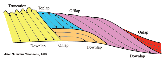
Unconformities are seen between numerous layers of the basin. These
are believed to be not only the cause of basin uplift, but also
erosion before deposition. The sedimentary layers that form the
basin depict a rich history of sea movement in the region. An
unconformity marked by a downward shift in coastal onlap landward
of the depositional-shoreline break is called regressive. It lacks
erosion associated with stream rejuvenation and a basinward shift
inwards. An unconformity characterized by stream rejuvenation and
fluvial incision where sedimentary bypass the shelf and an abrupt
basinward shift occurs such as from coastal onlap is called
transgressive. Such unconformities are interpreted to form when the
rate of sea fall exceeds the rate of basin subsidence at the
depositional shoreline break, producing a relative fall in sea
level at that position. The terminations expressed by strata within
these depositional sequences are used to identify one strata
sequence from another. Terms expressed in this diagram include
truncation, toplap, offlap, onlap and downlap. The moves to the
left capture how these various geometric relationships are
connected to rates of sedimentaion and changing base level.
A conspicuous unconformity is present beneath Devonian strata along
the flanks of the Cincinnati arch. On the outcrop, Devonian rocks
may rest on various formations in the Silurian or Upper Ordovician.
The gap in time may represent as much as 250 to 300 ft of the
stratigraphic section. The upper contact of the Silurian system is
everywhere a regional erosional unconformity. Outside the two main
outcrop belts, that is, along the crest of the Cincinnati arch, the
Silurian rocks are commonly missing and Ordovician rocks are
overlain unconformably by Devonian rocks. Sometime after deposition
of the Silurian sediments, downwarping occurred on both the east
and west flanks and the Silurian sediments were eroded off the
crest of the arch prior to the deposition of the Devonian
sediments, producing a profound unconformity.
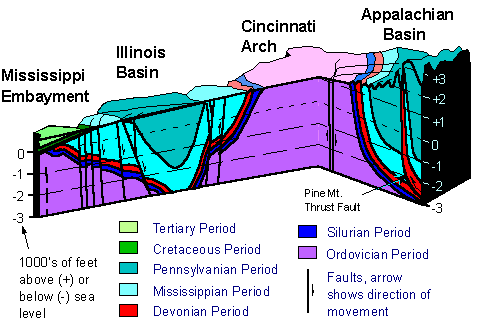
The basal unconformity truncates rocks ranging in age from Late
Ordovician on the crest of the Cincinnati arch to Middle and Late
Silurian on the flanks of the arch. In most exposures, this
unconformity appears planar. The erosion that preceded the Middle
Devonian accumulation of carbonate rocks took place during an
interval of mild tectonic warping along structures such as the
incipient Cincinnati arch and the tighter folds that parallel or
are normal to the present strike of the Appalachian Valley and
Ridge province and the Pine Mountain thrust fault.
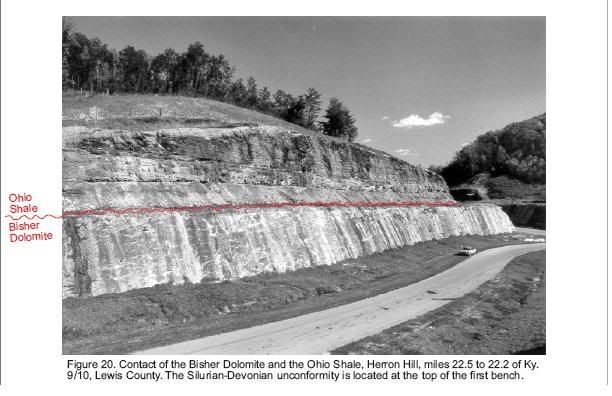
Come visit a Silurian-Devonian Unconformity, or Gap in Time along
the AA Highway where as much as 30 million years of geologic record
is missing. Travel to mile marker 22.5 in Lewis County. The Ohio
Shale of the Late Devonian Period age uncoformably overlies the
Bisher Dolomite of Middle Silurian Age. The missing Middle and
Lower Devonian and Upper Silurian units that are present in the
subsurface represent 30 million year of missing time.

The questions you will be answering are based on the outcrop
located on the south east side of the roadway. The unconformity is
profound and clearly visible on the top of the first bench of rock.
Note how the lower sedimentary strata (from the Silurian Period,
between about 438 and 408 million years ago), which were deposited
on the seafloor and were therefore originally horizontal, are now
vertical and twisted. Once they had been turned vertically (or
perhaps during that process), these older strata were highly
eroded. The overlying, younger strata (from the Devonian Period,
about 408 to 367 million years ago) retain the horizontality of
their original deposition.
Using the Law of Superposition, the Silurian Rock being older is
the bottom layer represented. Make the calculations and estimates
to the following questions and email them. Post a picture of the
unconformity of this very interesting rock display with your log.
You guys are becoming quite the geodetectives!
1. Estimate how many feet of rock represents the gap in time
(unconformity) of 30 million years represented in this outcrop.
a. 10 feet
b. 20 feet
c. 25 feet
2. If the height of the entire outcrop here from bottom to top is
roughly 100 feet, how much Silurian versus Devonian Rock sequence
is represented?
a. Silurian 50 feet/Devonian 40 feet
b. Silurian 60 feet/Devonian 20 feet
c. Silurian 50 feet/Devonian 25 feet
3. Shoot an elevation of the base of this outcrop.
From the results of studies on the origins of the various kinds of
rocks (petrology), coupled with studies of rock layering
(stratigraphy) and the evolution of life (paleontology), geologists
reconstruct the sequence of events that has shaped the Earth's
surface. The Earth’s surface is a complex mosaic of exposures of
different rock types that are assembled in an astonishing array of
geometries and sequences. The myriad of rock outcroppings that link
the past have enabled investigators to integrate rock sequences in
many areas of the world and construct a relative geologic time
scale. Modern scientific understanding of the complicated story
told by the rock record is rooted in the long history of
observations and interpretations of natural phenomena that are
almost like chapters in a story book that portrays billions of
years of time.
Now buckle up! It’s time to head back down the AA Highway for
another geologic geocaching adventure!

Additional Hints
(No hints available.)
Treasures
You'll collect a digital Treasure from one of these collections when you find and log this geocache:

Loading Treasures