
 Parking is at the end of Templin Highway at the gate then
walk down the road and cross the bridge over Castaic Creek.
Just after the creek follow the trail up the creek a short
distance. The no trespassing signs are intended to keep you on
the trails until you leave the proximity of the creek that
drains into Castaic Lake.
Parking is at the end of Templin Highway at the gate then
walk down the road and cross the bridge over Castaic Creek.
Just after the creek follow the trail up the creek a short
distance. The no trespassing signs are intended to keep you on
the trails until you leave the proximity of the creek that
drains into Castaic Lake.
There are four types of unconformities (more details are at
http://geology.about.com/od/geoprocesses/a/unconformities.htm),
the Angular Unconformity, the Disconformity, the Paraconformity,
and the Nonconformity. Each type represent the same thing, a period
of geologic time when rocks have not been deposited or have been
eroded. This places rocks of significantly different ages adjacent
to each other. The difference between each type is the relationship
between the older and younger rocks. Below is a description of each
type of unconformity which you will use to identify the type of
unconformity at the coordinates.
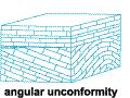 The Angular Unconformity
The older layered rock has been tilted or folded and eroded. The
younger rock is then deposited on the eroded surface. Here the
older rock will look to be at an angle to the younger rock.
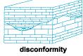 The Disconformity
The older layered rock eroded with the younger rock being
deposited on this erosional surface. The older rock layers will be
parallel to the younger rock layers, but the erosional surface is
easily noted by an irregular surface or fossilized soil between
them.
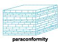 The Paraconformity
The older layered rock eroded with the younger rock being
deposited on this erosional surface. The older rock layers will be
parallel to the younger rock layers, but the erosional surface is
not noted. The only way to recognize the missing time is from other
means such as index fossils, radiometric dating, or detailed
mineralogical analysis.
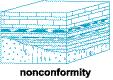 The Nonconformity
The older rock is some non-sedimentary rock. The younger
sedimentary rock is deposited directly on top of the
non-sedimentary rock.
 From the coordinates, look west across the
creek. The lower portion of the hillside is made up of
mudstone of the San Francisquito Formation. This formation is
a deep to shallow marine rock that was deposited mostly in the
Paleocene
(~65 to ~55 million years ago). Layers of sandstone and lenses
of conglomerate are also found in this formation.
From the coordinates, look west across the
creek. The lower portion of the hillside is made up of
mudstone of the San Francisquito Formation. This formation is
a deep to shallow marine rock that was deposited mostly in the
Paleocene
(~65 to ~55 million years ago). Layers of sandstone and lenses
of conglomerate are also found in this formation.
The upper portion of the hillside is composed of conglomerate of
the Castaic Formation. This formation was deposited during the
Miocene (~23 to
~5 million years ago) in fan deltas and alluvial fans that emptied
into a sea.
Doing a little math, you can see that at least 32 million years
of geological history is missing between the deposition of these
two formations.
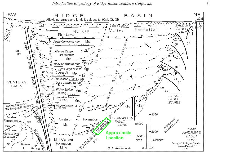
The approximate location of this EarthCache in relation to the
rest of the Rigde Basin is shown in the clickable image.
 The Ridge Basin formed in the Late
Miocene and
Early
Pliocene
(~ 11 million years ago to ~4 million years ago). At that time
most of the movement on the San Andreas Fault system occurred
on the right lateral transform San Gabriel Fault, which is
less than a mile to the east The San Gabriel Fault is not
exactly straight (just as the San Andreas is also not
straight). As a result, there are areas that push up against
eachother creating hills and other areas are pulled apart
creating depressions or basins. The green area in the figure
represents the basin that was created in this area. It is is
about 24 miles long, 6 miles wide and about 8 miles deep and
has been named the Ridge Basin .
The Ridge Basin formed in the Late
Miocene and
Early
Pliocene
(~ 11 million years ago to ~4 million years ago). At that time
most of the movement on the San Andreas Fault system occurred
on the right lateral transform San Gabriel Fault, which is
less than a mile to the east The San Gabriel Fault is not
exactly straight (just as the San Andreas is also not
straight). As a result, there are areas that push up against
eachother creating hills and other areas are pulled apart
creating depressions or basins. The green area in the figure
represents the basin that was created in this area. It is is
about 24 miles long, 6 miles wide and about 8 miles deep and
has been named the Ridge Basin .
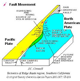
 As the basin formed, on the east side of the
San Gabriel Fault where you are, it filled with sediments that
eroded off of hills that formed on the north end of the basin.
Most of the sediments came from the hills on the east side
forming filling the center of the basin with fine grained
sediments. However, along the west side, the granites and
gneises in the hills formed steep hills that periodically
filled the edge of the basin with a breccia. As the basin filled, movement on
the fault carried sediments on the east side of the fault off
to the south, extending the basin.
As the basin formed, on the east side of the
San Gabriel Fault where you are, it filled with sediments that
eroded off of hills that formed on the north end of the basin.
Most of the sediments came from the hills on the east side
forming filling the center of the basin with fine grained
sediments. However, along the west side, the granites and
gneises in the hills formed steep hills that periodically
filled the edge of the basin with a breccia. As the basin filled, movement on
the fault carried sediments on the east side of the fault off
to the south, extending the basin.
Logging requirements:
Send me a note with :
- The text "GC1VK9V Castaic Unconformity – Which kind is it?" on
the first line
- The number of people in your group.
- What kind of unconformity is seen here?
- Why is it so difficult to see the layering in the lower portion
of the hillside?
The following sources were used to generate this
cache:
- Link, M.H., and Crowell, J.C., 2003, Guide to
field stops, Ridge Basin, southern California, in Crowell, J.C.,
ed., Evolution of Ridge Basin, southern California: Aninterplay of
sedimentation and tectonics: Boulder, Colorado, Geological Society
of America Special Paper 367, p. 205–247. © 2003 Geological Society
of America
- Crowell, 2003, Introduction to geology of Ridge
Basin, Southern California, Geological Society of America Special
Paper 367, 2003
-
http://www.answers.com/topic/unconformity
- Crowell, 2003, Tectonics of Ridge Basin region,
Southern California, Geological Society of America Special Paper
367, 2003