The Cache is a 1 Litre, camoflaged, Lock-N-Lock. It contains a number of Trade Items, Log Book and Allweather Pen plus a FTF Prize a World Caching "Desert" un-activated trackable Geocoin.
This cache is dedicated to the hardy Canadian Pioneers of the
Dominion Land Survey (DLS).
The DLS was formed in 1869 to start to survey the the vast lands recently acquired by the Dominion of Canada from the Hudson Bay Company.
The lands were known as the Northwest Territories and would eventually be divided into the Provinces of Alberta, Saskatchewan, Yukon, Northwest Territories and Nunavut, with an enlargement of the Province of Manitoba at the start. The object of the Survey was to divide some 200 million acres into Townships, which Measured about 6 miles (9.7 km) square, then Sections, which measured about 1 mile (1.6 km) square, and eventually into about 1,250,000 one quarter sections of 160 acres (64.8 ha) each.
These 1/4 Sections would the be "granted" as homesteads to settlers under a program called "Western Land Grants". The aim was to settle the lands between Manitoba and, what was hoped would be, the Province of British Columbia, thus making a transcontinental Railway viable. This Railway was the promise that would bring British Columbia into Confederation in 1872.
ScouterHerb's grandfather, Joseph Herbert Pinkerton, was one of those who received a "Western Land Grant" and you may view a picture of it below. A complete searchable list of the Western Land Grants is available online at the National Archive Web Site.
Heading west from the Red River at Pembina on September 8, 1869, Lt. Col. John Stoughton Dennis, an Ontario provincial land surveyor, marked out on the ground the first 10 miles of the 49th parallel, which was the border between Manitoba and the United States. At the 10 mile point his assistant started to lay out the north-south principle or Prime meridian, to which all DLS surveys were to be referenced. This Prime meridian turned out to be 97° 27´ west Longitude. Subsequent Meridians were established as follows: W2 at 102°, W3 at 106°, W4 at 110°, W5 at 114° and W6 at 118°, and at the same time the layout of Base Lines begining with the 1st Base Line being the 49th Parallel. Subsequent Base Lines were established every four Townships, or 24 miles (38.6 km), parallel to and north of the 1st Baseline. Half way between each Baseline a correction Line was established to compensate for convergence of the Meridians as they went north. Most of this task was completed by 1890. The survey by the DLS was to continue until renamed in 1979, However most of the townships had been surveyed by 1905.
The prime measurement tool, in the early years, was a device called " Gunter's chain". It consisted of 100 links which were interlinked to fold back on each other so it could be held in one hand. Each link was 7.92 inches (20.1 cm) long and thus the 100 links, stretched out, measured 792 inches or 66 feet (20.1 m). Some other facts of note are that 10 chains = one furlong and 80 chains (8 furlongs) = one mile (1.6 km) or 1,760 yards, or 5,280 feet. You will need some of these facts to find the cache
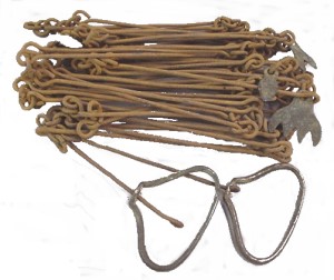
A Gunter's Chain
The above coordinates will take you to a survey pin in a shallow hole about 1½ Links south of a Survey Marker Post, just off of Township Road 250, where it intersects Highway 68. You can park on Township Road 250.
Township Road 250 is the 7th Baseline, which means it is about 144 miles (232 km) north of the 49th parallel or U.S. Border, and is the dividing line between Townships 24 to the South and 25 to the North. Highway 68 at this point is following the Range line between Range 5 and Range 6 West of the 5th Meridian, which Barlow Trail in Calgary follows at the 7th Baseline as it passes the Airport, thus you are about 30 miles (48.2 km) west of that Trail. It is also the dividing line between the Municipal Districts of Rockview (to the East) and Bighorn (to the West). Thus this intersection from a Survey point of view is an important one.
To learn more about the Township System click Here
To see a map of the Alberta Townships click Here
To locate the cache you must project a waypoint, from the pin, 4.21 Chains on a bearing of 151º True. Then proceed to this waypoint, keeping in mind your school training in crossing a road!
REALITY CHECK! - YOU DO NOT HAVE TO CROSS ANY FENCES OR GO THROUGH ANY GATES.
If your GPSr indicates otherwise, re-check your projection!
If you wish to read more on the amazing lives of the hardy pioneers of the DLS, check to see if your library has a book titled "VISION OF AN ORDERED LAND - the story of the Dominion Land Survey" authored by James G. MacGregor. It tells their story using many of their own reports and diaries! It is an excellent read.