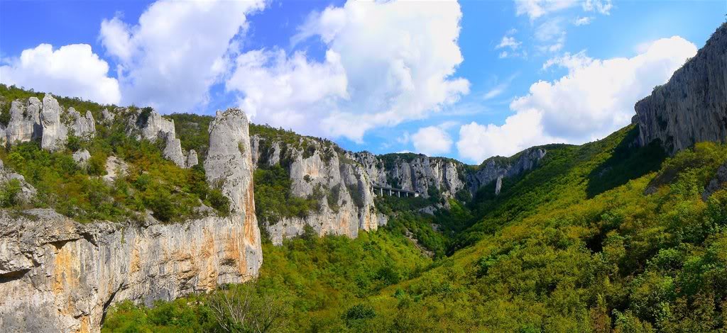
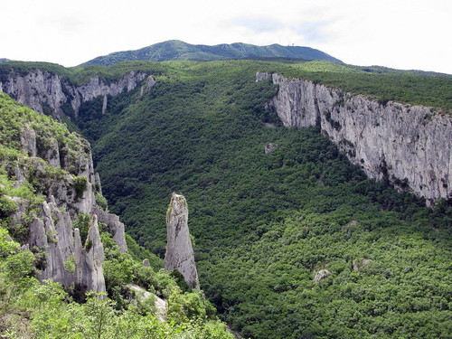
Vela Draga
This earthcache takes you to the amazing place
in the SE of Istria Peninsula, Croatia. Vela Draga is a huge canyon
under Ucka massif. It belongs to Ucka Nature Park.
Vela Draga - Geomorphological natural
monument
Since 1963 vela Draga has been legally protected
as a „natural area reserve“ and since 1968 as a
geomorphological natural monument.
„The Vela Draga“ instructive path
passes the edge of the impressive canyon of the same name and by
means of interpretation boards makes the visitors familiar with
this monument of an outstanding geomorphological value. The text of
interpretation boards is written in a simple language meant for
general public and explains the geological phenomena of the
formation of the Ucka massif and the Vela Draga canyon itself.
Apart from geological phenomena the path
provides information about alpinism and sports climbing, sports
present in Vela Draga since 1931. With its impressive rocks and
limestone towers up to 100 m high, including more than 60 well
arranged climbing routes in a canyon surroudings, Vela Draga
presents one of the most beautiful climbing grounds in Croatia.
The rocks of Ucka Mountain have been
formed in the vast Tethys Ocean through a long geological
time, from Cretaceous period 140 million zdar ago until mid
Tertiary 30 million years ago. Endless and warm shallow marine
waters were inhabited by numerous organisms protected by calcite or
aragonite shells. Millions of years of settling of their skeleton
remains have formed thick sediment layers which gradually, through
compacting and cementing processes became solid rocks that we know
under the name of limestone.
Collision of the African and European
plates, which started by the end of the Cretaceous period 65
million years ago, and is still ongoing, has caused the Ocean
shrinking, accompanied by intensive tectonic shifts. The
originally horizontal layers settled into the Ocean‘s bottom,
and then started creasing, cracking and raising above the sea, thus
creating huge mountain chains such as the Alps and Dinara
massif with Ucka as their part. Fine-grained sediment
resulting from abrasion was periodically carried off into the sea
depths by submarine avalanches, forming stratified rocks called
flysch. So the former vastness of the Tothys was reduced to
the sole area of the Mediterranean Sea. With current speed of
continent movement of 2-3 cm per year, in some 50 million years
even the Mediterranean could completely disappear due to the
raising of its bottom into a new mountain chain.
After the raising of Ucka, which was the most
intensive in the mid Tertiary, approximately 30 million years ago,
the limestone in Vela Draga got exposed to atmospheric processes
causing karstification – melting, abrasion and erosion which
has been continuously forming the canyon ever since. Karstification
gets even more intensive underground than on the surface, with
water accumulating into strong currents that melt the rock and
widen the cracks transforming them into cave passages. Such surface
and underground karstification fragmentation along the fissures,
aided with time, was the main sculptor of the canyon. Among other
interesting sites, the canyon harbours a detailed story of
fossil-rich limestone – the building material of the canyon
– and a representation of surface erosion that is forming it
still.
Coordinates will take you to the free parking
place, where is also located the start point of the instructive
path. Path lenght is 600m and it takes you about 30 minutes to go
to the viewpoint and back to the parking spot. You will find
answers to following questions on the information boards on the way
to the viewpoint.
To get the log
permission for this earthcache you have to answer the following
questions and to do a task:
1) There
are numerous remains of shells structuring the rock. What is the
name of these shells?
2) What
is the name of legendary traditional rock climber who is mentioned
on one of the information boards?
3)
Please, take a picture at the location (viewpoint), which may
include either you, your GPS or some proof that you really reached
the viewpoint and attach it to your log.
Please email me your answers (via GC-Profile) latest when you
log this cache (you don't have to wait for a permission to log). If
your answers are incorrect, I will inform you.
Logs and e-mail only in english please!
Text prepared by: Ramie Lackovic, B.Sc.Geology; Ph.D. Goran
Susic