"The Earth is a ball and it takes about 40.000 km to round the Earth once." This is an approximation most people make. But how are the facts exactly?
The circumference of the earth is 0.34% (or 134,336 km) bigger at the equator than on the poles. This is due to the centrifugal force (Cotopaxi a little bit further north) of the rotation of the Earth. So if we look at the diameter the Polar one is 42,77 km smaller than the one in the tropic zone. The Geodid (the sea level) differs yet another ±100 metres. The Earth therefore is not exactly round. It is an approximation we make to simplify calculations.
However, this leads to a whole other discussion when it comes to mountaineering.
The highest mountain of the world is now known to be Mt. Everest. But it depends on the simply fact where you start measuring. If you start calculating from the base of a mountain, the Mauna Kea on Hawaii is the tallest one. It reaches from the Pacific Sea bottom up to forming an island above sea level. Everest with 8.848 m is only the highest mountain if you start at sea level. For years the highest mountain in the world used to be Chimborazo in Ecuador because geographically it is furthest away from the calculated "Middle of the Earth". And the Himalayan region was not thouroughly explored with technical equipment yet. Chimborazo is pretty close to the biggest equatorial diameter. Therefore it lies 2 km further away from the middle of the Earth.
Additionally the maximum of the centrifugal force of the Earth is reached at the top of the mountain. And because it is furthest away from the middle the gravitational force reaches a minimum too. This means the gravitational acceleration is only 9,767 m/s². An object - or a person - weights a bit less when at the top.
| polar circumference of the Earth |
39.940,638 km
|
| equatorial circumference of the Earth |
40.075,004 km
|
| polar diamater of the Earth |
12.713,500 km
|
| equatorial diameter of the Earth |
12.756,270 km
|
| distance Everest - Middle of the Earth |
6.382,414 km
|
| distance Chimborazo - Middle of the Earth |
6.384,557 km
|
| rotation period of the Earth |
23 h 56 min 4 s
|
Educational information:
Chimborazo highest mountain in Ecuador with 6267 metres (measured in 1993, commonly it is known to be 6310 m) above sea level. It towers about 2500 metres above it's surroundings and is a prominent feature of the "skyline" of Riobamba. There are various theories where the name comes from. If you ask a local native they will tell you that the mountain is a woman - an Icy Woman&. It could be a combination of the Cayapa word for woman shingbu; and Quichua word for ice razo. I've also heard somebody in a small village refer to it as Urcorazo, meaning Mountain made of ice.
The upper part from about 5100 m is host to glaciers which sometimes reach down to 4600 m. The ice masses have lost much volume due to global warming, ash coverings and heat emissions from it's Eastern neighbour Tungurahua and - according to newest studies published in 2004 - also the El Niño phenomenon.
This accumulated ice is the source for water of the provinces Bolivár and Chimborazo. Hieleros (from the Spanish word hielomeaning ice) remove ice from the mountain and sell it on the markets in Guaranda and Riobamba. In earlier times it was even sold down in the coastal cities of Babahoya or Vinces.
Underneath it's glaciers the mountain is old and scientists suspect, that it used to be much higher. The last eruption was around the year 640. But there is a 500 year variation possible. Officially the volcano is or used to be inactive. However, a few years ago water was found 25 m underneath the top and seismologic measurements have confirmed the slightly active status. But offical statements are not published yet.
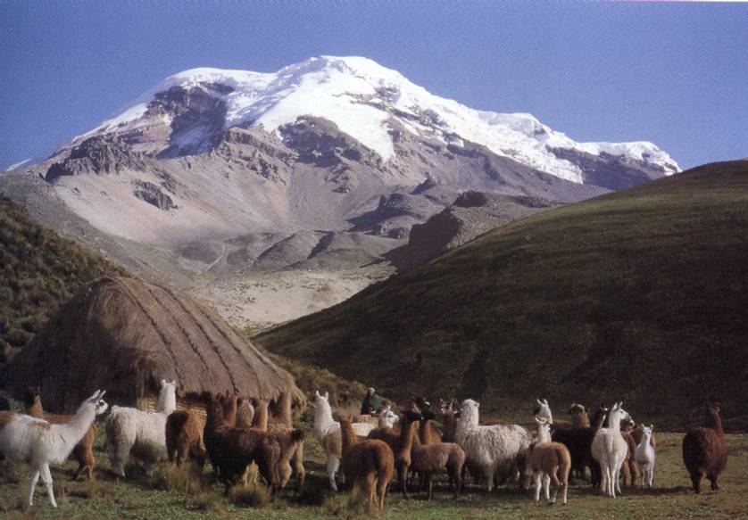
Chimborazo is in the middle of an animal reserve. Amongst llamas (with some alpaca features, see picture below) and a few guanacos the main attractions are Vicuñas. Here is the only place in Ecuador where those graceful lamas can be seen. A herd of about 200 animals were donated by Chile several years ago and are now raised in this faunistic reserve.
If you want to climb Chimborazo you have to have experience in mountaineering. Ice ax, crampons, appropriate clothing, ropes, etc are equally essential as a good acclimatization. Due to nearby Tungurahua a lot of the snow on the top has melted and there are a lot of blank patches - you are walking on ice and over crevasses. Go early (just after midnight) because of occuring avalanches. If, however, you are an experienced mountaineer, you will find the climb moderately easy technically.
As the mountains lies in a Natural Reserve you will need to pay a $10 entrance fee as to most National Parks in Ecuador.
Just a quick tip if you are taking the train from Riobamba via the Devil's Nose: sit on top of the roof on the right!
Now on to your tasks here. Apart from the pictures which must be included in your log, please do not include the answers. Mail them to me instead. Though I speak Spanish it would be nice, if your log contains at least a bit of English.
1. You need to have reached either of the huts on the way up the mountain. Look at your GPS - how high are you? Post a picture with you and your GPS (visible display with numbers) at this point. If you go up the mountain - congrats and please post a picture with you on the top (including your GPS).
2. Mail me the coordinates of the Simon Bolivar stone monument.
Additional information:
The present age of the mountains is estimated at about 60 million years. According to most scientific literature the formation of the mountain range only took about 3 million years.
The Andes resemble a standard example of plate tectonic processes of an ocean-continent-convergence. The movements were caused by the subduction of the Nazca plate benath the South American plate about 150 million years ago. At the subduction line – the boundary between both plates – we find now two deep sea trenches. The Peruvian oceanic trench is 6262 m b.s.l., topped by the Atacama trench which goes down to 8066 m below sea level. The orogenesis (mountain formation) started in the Tertiary (Jurassic Period), but most of the formation of the present appearenace took place in the Pleistocene (the Cretaceous Period). By faulting, folding and uplifting sedimentary and metamorphic rocks of the ancient cratons to the east. The lack of erosion lead to a stabilisation of the Andes-Orogen in the west. This is the reason why the the Altiplano is so wide.
Until today there are still various geodynamic processes in the formation of the Andes:
• Convergence movement up to 10 cm per year
• Vertical uplifting up to more than 1 mm per year
• Extreme thickness of the crust (60-70 km)
All the above mentioned processes lead to more compression and a continuation of the thickness ot the crust towards the East. Because the plates are still in movement the orogenic events are responsible for earthquakes and volcanic eruptions.
The Andes mountain range is host to a lot of active volcanoes; some of them the highest active ones in the world.
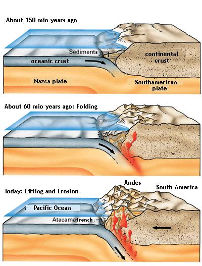
language-changed image from klett.de
