Urban Wetlands Of Kent County EarthCache
Urban Wetlands Of Kent County
-
Difficulty:
-

-
Terrain:
-
Size:  (other)
Please note Use of geocaching.com services is subject to the terms and conditions
in our disclaimer.
This is an "earthcache and dash" of sorts since parking is directly in front of the area of observation. There is no physical container hidden at GZ. This is an earth science lesson on Urban Palustrine Wetlands. You must read the description and answer the required questions via e-mail before logging a find.
Sometimes you find the coolest things in the most unexpected places. This wetland is located just off of South Bay Rd. next to a fast food joint. It's part of the Levy Court Wetland Project funded through the Delaware Department Of Agriculture's Urban Forestry program. So what can we learn about wetlands?
•
A wetland is a land area that is saturated with water, either permanently or seasonally, such that it takes on the characteristics of a distinct ecosystem. Primarily, the factor that distinguishes wetlands from other land forms or water bodies is the characteristic vegetation that is adapted to its unique soil conditions: Wetlands consist primarily of hydric soil, which supports aquatic plants. Wetlands vary widely due to local and regional differences in topography, hydrology, vegetation, and other factors, including human involvement. Wetlands can be divided into two main classes: tidal and non-tidal areas.
•
Wetland hydrology is associated with the spatial and temporal dispersion, flow, and physiochemical attributes of surface and ground water in its reservoirs. Based on hydrology, wetlands can be categorized as riverine (associated with streams), lacustrine (associated with lakes and reservoirs), and palustrine (isolated).
•
Sources of hydrological flows into wetlands are predominately precipitation, surface water, and ground water. Water flows out of wetlands by evapotranspiration, surface runoff, and sub-surface water outflow. Hydrodynamics (the movement of water through and from a wetland) affects hydroperiods (temporal fluctuations in water levels) by controlling the water balance and water storage within a wetland.
•
Landscape characteristics control wetland hydrology and hydrochemistry. The O2 and CO2 concentrations of water depend on temperature and atmospheric pressure. Hydrochemistry within wetlands is determined by the pH, salinity, nutrients, conductivity, soil composition, hardness, and the sources of water. Water chemistry of wetlands varies across landscapes and climatic regions. Wetlands are generally minerotrophic with the exception of bogs. Bogs receive their water from the atmosphere and therefore their water has low mineral ionic composition because ground water has a higher concentration of dissolved nutrients and minerals in comparison to precipitation. The water chemistry of fens ranges from low pH and low minerals to alkaline with high accumulation of calcium and magnesium because they acquire their water from precipitation as well as ground water.
•
•
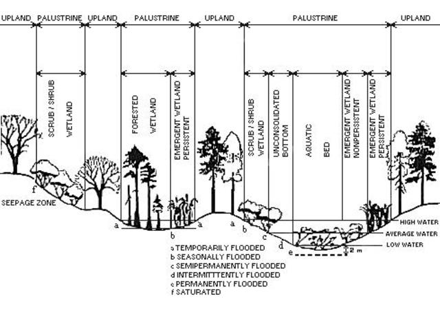
What you're looking at is a Palustrine wetland. In an urban setting like this, the main function of the Palustrine wetland is to improve water quality by acting as a buffer for water running off of the land and parking lots before it reaches local surface water. The Palustrine System includes all nontidal wetlands dominated by trees, shrubs, persistent emergents, emergent mosses or lichens, and all such wetlands that occur in tidal areas where salinity due to ocean-derived salts is below 0.5 %. Palustrine wetlands are often called swamps, marshes, potholes, bogs, or fens. It also includes wetlands lacking such vegetation, but with all of the following four characteristics: (1) area less than 20 acres; (2) active wave-formed or bedrock shoreline features lacking; (3) water depth in the deepest part of basin less than 2 m at low water; and (4) salinity due to ocean-derived salts less than 0.5 %.
•
In order to claim a find on this earthcache, you must contact me via my geocaching.com profile with the answers to the following questions:
1. Upon observing the Palustrine wetland before you, how and why do you think it may have been formed?
•
2. What are two positive impacts that Palustrine wetlands can have on the environment?
•
3. Name two unique characteristics of this particular area that categorize this as a Palustrine wetland.
•
4. Look at the above image and compare it to the Palustrine wetland before you. Using what you've observed, is it -
A. Temporarily Flooded
B. Seasonally Flooded
C. Semi-permanently Flooded
D. Intermittently Flooded
E. Permanently Flooded
F. Saturated
•
5. Using what you've learned, do you think that this new wetland project is serving it's purpose in the immediate area and how can you tell?
•
6. Optional - Post a photo of yourself at the posted coordinates.
It's preferred that you send your answers before logging a find, however, if you must log first, please send your answers within a reasonable amount of time (at least 4-5 days) so your log does not get deleted. If for some reason your log gets deleted, this is likely the reason. Enjoy the area and please be respectful.
| This Earthcache was placed by an: |
 |
Additional Hints
(No hints available.)