This earthcache is designed to show how today’s rivers are
regulated. The above coordinates will take you to a USGS Gage
Station. USGS is the United States Geological Survey. These
gauging stations are used for water resources, specifically the
Grand River in this case. The station here is continuously
measuring the depth and the amount of flow of the river.
It is very important to monitor and control the river’s flow
for several reasons. First is the control of flooding or at least
the warning of flooding. Since the rivers flow is regulated by
damming, these gauging stations relay the information to do this
regulating. Another important reason for this gauging and
regulating of the river is to limit erosion of the river banks.
Although erosion will always take place it can be held to a
minimal. Ground water also depends on these regulated flows. Ground
waters include some small lakes, marshes and wetlands.
The Grand River is the longest river in Michigan at about 260
miles. It begins in the wetlands and small lakes of north eastern
Hillsdale County. The river is fed also by 8 other rivers that
connect along the way. The Grand River watershed includes 9
counties before running into Lake Michigan.
To view in real time the flow and height of this river click
here. This is also where you will find some of the information
you will need to log this cache.
To log this cache we ask you to complete the following. All that
should be posted with your log will be a photo. All answers should
be e-mailed to us and not posted in your log. Go ahead and log your
find at the same time you're sending your email answers. We reserve
the right to delete find logs that haven't emailed their
answers.
1. At the posted co-ords look at the waterline of the river. E-mail
the approximate distance from the waterline to the walkway.
2. Go to the
USGS website and look at the water level and the water flow
charts. E-mail us the flow rate and the water lever the river was
at the time of your visit. With this site reporting in real time it
should be easy to see the time frame that you were here.
3. While logging your find please post a picture of yourself/team
on the walkway with the gage station in the background.
This cache was a fun way to work with our good friend Rattrak.
We have put together two of the same type of cache on either side
of the state, visit Tim's here:
Moravian Gage Station. I would like to thank him for this
opportunity!
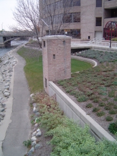
Here is a shot of the gage station. It has no identifying marks but
does have a radio antenna and a yellow beacon on its roof.
Congratulations to CCSquire on the FTF!