| The Global Positioning System (GPS) has dramatically reshaped surveying and navigation in many parts of the world. The use of GPS positioning has become increasingly widespread. The need for a “truth” against which to test GPS positioning accuracy and precision has led to the establishment of GPS validation networks across Canada, also known as basenets, to serve as a physical standard for evaluating GPS equipment, software and positioning methodologies.
A GPS validation network is typically comprised of between 5 and 10 forced centering pillars or piers. Usually two of these pillars are also part of an Electronic Distance Measurement (EDM) calibration baseline and form the core of the network. The network design provides GPS baselines of varying lengths, usually ranging between 1 and 100 kilometres, and the design and location of pillars is such that:
- Forced centering is used to eliminate centering error
- Sites are easily accessible
- Sites are generally clear of obstructions above 10 degrees from the horizon
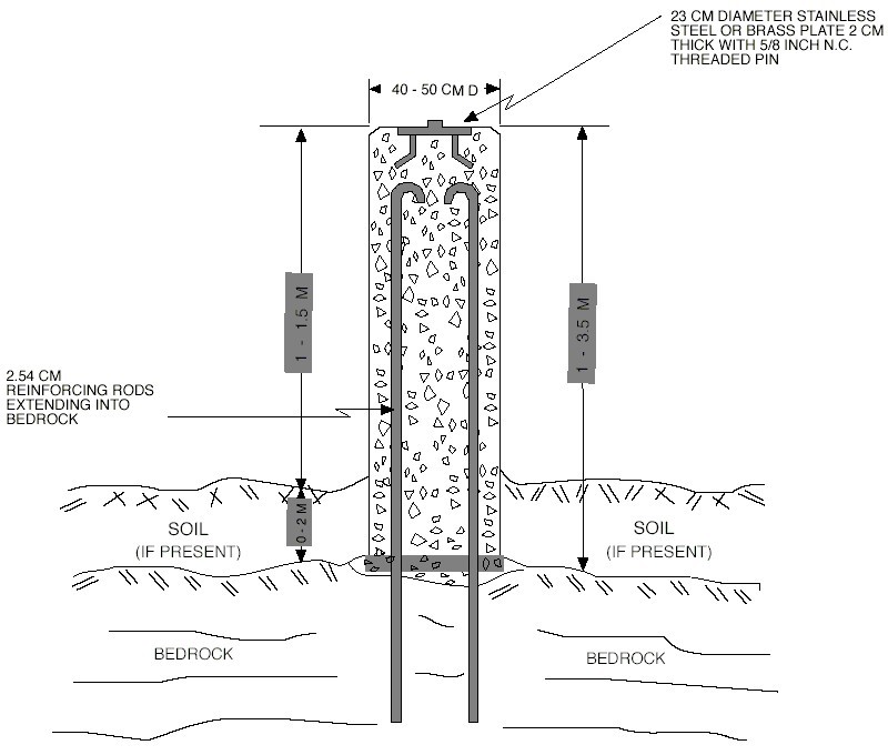
- For stability and longevity, pillar monumentation is carried out using the same specifications as for EDM calibration baseline pillars
The Winnipeg GPS validation network was mainly constructed in 1989 by the Manitoba Department of Natural Resources, and consists of six concrete forced centering pillars. Two of these pillars, 74RCB1 and 74RCB5, are part of the Manitoba EDM calibration baseline and were constructed in 1974. One of the pillars, station 89R001, is a Canadian Base Network (CBN) station.
All of the caches are located within a 40 kilometre radius of the centre of Winnipeg. The basic configuration of the network, provides baseline lengths ranging from 7 to 50 kilometres.
The Winnipeg basenet was first observed with GPS in 1990 by GSD, NRCan, with a second series of measurements carried out in 1991. Ashtech LD-XII and M-XII GPS receivers were used to collect the observations.
|
 |
This multi-cache will take you to each of the six Winnipeg GPS Validation Network stations. At each station you should collect a series of GPS measurements, and record them both in the station log book, and in your geocaching.com log entry. (Thanks to Ruzter and the +/- 4 meters = +/- 8 meters cache for the idea!) Measurements requested are date, time, number of satellites locked, WAAS status, and distance and bearing to the waypoint. Log sheets are available for this information online and in each of the caches.
This is an "activity" cache, not a "hidden" cache. All containers are firmly attached to station monuments with cord. If you can't immediately find the container, it's been muggled.
Feel free to trade items at any of the caches.
The first cache is Pier D, at coordinates 50° 03' 46.08554”, 96° 53' 8.27709”. Station access description for Pier D is:
Pier D is located at the Northwest corner of Birds Hill Provincial Park on the East side of Highway 59 approximately 20.9 m East of Ashfield Road centre line. From the intersection of Highways 101E and 59N to Grand Beach, proceed North on Highway 59 for approximately 18 km to Ashfield Road. Turn East (right). Station is located at the junction of Heritage Road, Ashfield Road and Rosco Road.
The cache pages for all six stages (which includes the access descriptions and co-ordinates) can (And should!) be downloaded here.
Hints
Here's some code to cut and paste into your logs to neatly format your data:
(Open square bracket)code(Close square bracket)

                 Time      # Sats                  Bearing
Station  Date    (HH:MM)   Locked  WAAS  Distance  (Degrees)
-------  ------  -------   ------  ----  --------  ---------
Cache 1
Cache 2
Cache 3
Cache 4
Cache 5
Cache 6

(Open square bracket)/code(Close square bracket)
|