| MAIERANGERKOGEL 2356 m |
|
Ein noch recht unberührtes Wanderjuwel des Aichfeldes ist der Maierangerkogel, welcher eine einsame Wanderung im Einklang mit der Natur ermöglicht und besonders für Ruhesuchende eine Oase der Erholung bietet. |
|
If you are looking for a secluded place in the mountains around the Aichfeld area, the Maierangerkogel is the summit of your choice. |
|
| Topo und Profil |
 |
 |
|
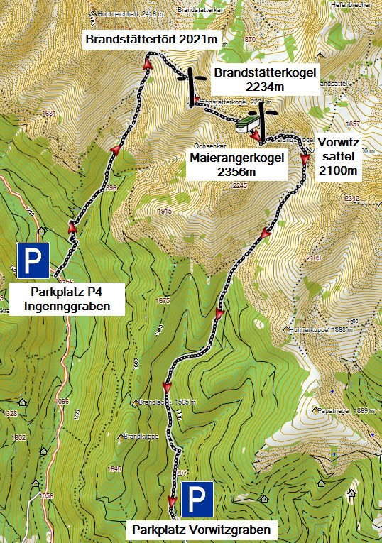
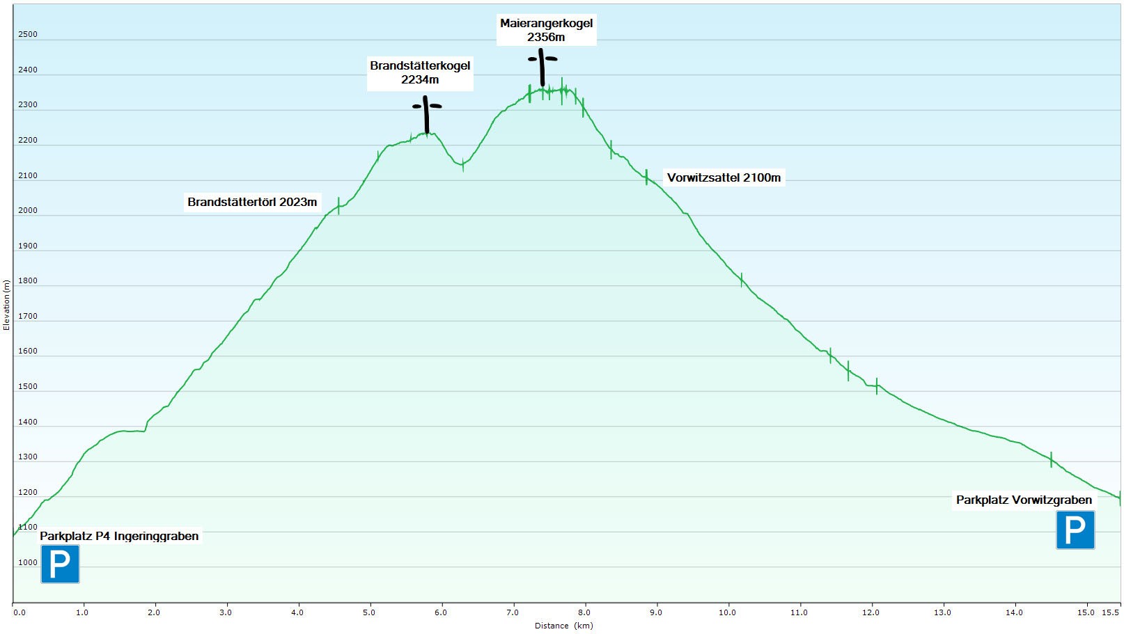
Parkplatz P4 im Ingeringgraben / Parking P4 Ingeringgraben: 1150 m
Parkplatz Vorwitzgraben / Parking Vorwitzgraben: 1125 m
Brandstättertörl / Brandstätter gap: 2021 m
Vorwitzsattel / Vorwitz col: 2100 m
Brandstätterkogel / Summit 1 Brandstätterkogel: 2234 m
Maierangerkogel / Summit 2 Maierangerkogel: 2356 m
Höhenmeter Anstieg / Elevation Gain: 1300 m
Höhenmeter Abstieg / Elevation Loss: 1275 m
Strecke / Distance: 15,5 km
|
|
Anreise / Approach: Die vorgestellte Tour beschreibt eine Überschreitung von Brandstätter- und Maierangerkogel, die nur mir zwei Fahrzeugen durchführbar ist. Fahrzeug 1 wird am Parkplatz im Vorwitzgraben abgestellt, mit dem zweiten geht es in den Ingeringgraben. .
Parkplatz Vorwitzgraben: Knittelfeld - Bischoffeld - hier rechts in den Vorwitzgraben abbiegen und bis zum Parkplatz beim Schranken fahren. .
Parkplatz Ingeringgraben: zurück nach Bischoffeld - weiter nach Ingering II - hier rechts abbiegen und in den Ingeringgraben bis zum gekennzeichneten Parkplatz P4 fahren. Alternativ kann man über jeden der beiden Wege an- und absteigen.
The tour desribed here leads you across the two summits Brandstätterkogel and Maierangerkogel and can thus be made only with two cars. No worries, any of the ways leading to Maierangerkogel, can be made in both directions! .
Parking Vorwitzgraben: Knittelfeld - Bischoffeld - turn right here - follow the rift-valley to the parking place at the closed gate. .
Parking Ingeringgraben: go back to Bischoffeld - turn right to Ingering II - here turn right again into Ingeringgraben - drive along the rift-valley until you reach parking place P4.
|
|
Anstieg / Ascend: Vom Parkplatz P4 im Ingeringgraben folgt man den Wegweisern Richtung Hochreichart und Brandstätterkogel. So gelangt man durch Hochwald hinauf zur Baumgrenze und steigt, dem gut markierten Weg folgend, vorbei am Petersbründl hinauf aufs Brandstättertörl (2 h).
Hier wendet man sich nach rechts - ganz im Gegensatz zu allen Hochreichartaspiranten - und steigt nochmals unschwierig die letzten 200 Höhenmeter hinauf auf den Gipfel des Brandstätterkogels.
Mächtig baut sich nun der Hochreichart vor einem auf - doch zuerst muss man nochmals knapp 100 hm in den Sattel zwischen Brandstätter- und Maierangerkogel absteigen, bevor man den letzten Anstieg in Angriff nehmen kann. Hier sind nochmals etwas über 200 hm zu überwinden, bevor man den einsamen Gipfel erreicht.
Starting at the parking place P4 in Ingeringgraben it takes you approximately two hours to reach the Brandstätter gap - just follow the signs "Hochreichart" and "Brandstätterkogel". You'll come by a wooden well, called Persbründl, where you can refill your drinking bottles. Continue your hike up to Brandstätterkogel by turning to the right at Brandstätter gap and follow the marked path for another 30 minutes until you reach the first summit.
Descend to the gap between Brandstätterkogel and Maierangerkogel (you lose approx. 100m) and start your last ascend of 200 m to the summit of Maierangerkogel.
|
|
Abstieg / Descend: Vom Gipfel des Maierangerkogels steigt man 250 hm in den Vorwitzsattel ab (das ist der Sattel zwischen Maierangerkogel und Seckauer Zinken) und wendet sich dort nach rechts - immer dem Graben folgend gelangt man entlang des markierten Weges schließlich zum Parkplatz im Vorwitzgraben.
Descend from Maierangerkogel down to Vorwitz col, which separates Maierangerkogel and Seckauer Zinken. Turn right here and follow the marked trail until you finally reach the parking place in Vorwitzgraben.
|
|
Um euch zusätzlich zu motivieren, gibt es für 10 absolvierte AUSTRIAN SUMMITS ein eigenes Abzeichen, das ihr im öffentlichen Benutzerprofil führen könnt.
As additional motivation, everyone, who can log at least 10 AUSTRIAN SUMMIT Caches, will get an award for his profile.
EINFACH MIT EINER LISTE DER ABSOLVIERTEN AUSTRIAN SUMMITS ANFORDERN! / AWARD REQUESTS VIA OWNER'S PROFILE (PLEASE ADD LISTING OF CACHES LOGGED)!
|
|
| Cachebeschreibung / Spoiler |
|
Der Cachebehälter ist eine MunBox, die ausreichend Platz für Tauschgegenstände bietet! In der MunBox befindet sich nochmals eine Lock&Lock-Dose, in der sich das Logbuch befindet. Und im äußersten Notfall, wenn alles andere nass geworden ist, liegt nochmals ein Petling mit Reservelogbuch in der Box! Bringt sicherheitshalber immer einen eigenen Stift mit - danke!
The cache is an ammo container with a Lock&Lock box inside. And, in addition, there is an emergency logbook available in a micro...!
Ursprünglicher Inhalt / Original Content
1 Logbuch (bitte nicht entfernen) / 1 logbook (please do not remove)
3 Stifte (bitte nicht entfernen) / 3 pens (please do not remove)
1 Petling mit Reservelogbuch und Stift (bitte nicht entfernen) / 1 micro with logbook and pencil (please do not remove)
FTF Geschenk / FTF present STF Geschenk / STF present
|
 |
|