I was finally able to rescue my images from their hostage situation. They are no longer blurred or plastered with the Photo Bucket Hostage icons.
I also re-linked the video file at the bottom of the description.
The Day the Lake Disappeared
During this Earth Cache, you will be visiting the beautiful Rip Van Winkle Gardens near New Iberia, La. In order to get credit for your find you must answer questions based on information within a folder in the back hallway of the welcome center. Since the cache is at an active Formal Gardens / Bed & Breakfast / Museum it is only active during business hours ( usually 9:00 am - 5:00 pm ). The personal in the shop are more then willing to discuss the "Disappearing Lake" as well as the rich history of your surroundings. If you would like to walk through the gardens, see a short movie about the region or tour the Jefferson house, there is an entrance fee. No fee is required to do the cache.
The Live Oak Gardens has a rich history that I do not touch upon in this cache
- Hidden Pirate Jean Lafitte treasure.
- Joseph Jefferson estate featured in many historic and architecture magazines.
- Mammoth bones and other archeological finds
- Beautiful and rich gardens

The Day the Lake Disappeared Earth Cache:
During the initial opening of the Gulf of Mexico, the shallow sea accumulated a thick layer of evaporates (known as the Louann salt formation). Salt is less dense then other sediments. Given enough time, salt under pressure will behave like a plastic, pushing its way towards the surface. As these salt columns push upwards, they turn the sediments upwards creating nice hydrocarbon (oil and gas) traps all around the salt dome.
Texaco installed a derrick and rig in Lake Peineur to capture the hydrocarbons that were trapped on the sides of the salt dome that formed the local high you are standing on. On the morning of November 20'th, 1980 at a depth of about 1240 feet the Wilson Brothers Drilling Co. got their bit stuck while drilling through the middle of the salt dome. Sometime around first light, the rig started to list to one side. Soon thereafter the evacuated rig workers watched as the entire platform and rig sank into the lake where the water depth should have been no more then 8 feet deep.
Over the past 60 years, the salt dome forming this localized high had been mined. It is estimated that over the life of the mine 34 - 40 million tons of salt were removed from the dome. The entrance to the salt mine was half a mile away from the well being drilled. On the morning of November 20'th, 51 miners and guests were working underground for the Diamond Crystal Mining Co. Around 8:00 in the morning, the lights in the mine flashed three times (the signal for an emergence evacuation). The workers of the mine proceeded to the nearest elevator on the 1300 ft level of the mine. After watching water on the 1300 foot level of the mine raise about 18 inches in 1 minute, a tractor operator radioed for the mine elevator be lowered to the 1000 ft level of the mine; he then ordered the workers on the 1300 ft level to walk up to the next level to catch the elevator. By 9:00 am all the people were evacuated from the mine.
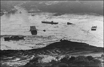
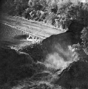
On the surface of the lake, all was not well either. Two men, who were fishing in their motorboat on the northern end of the lake, found themselves curiously stuck in the mud. After pushing themselves into deeper water they noticed that the lake level was dropping. Moments later they witnessed a churning vortex caused by the lake pouring down the drill hole into the mine. After some nearby barges snapper their mooring cables the fishermen made it safely to shore. Soon thereafter the whirlpool started to erode away at the nearby shore. Barges that were attached to the docks moments before were being sucked down the vortex; large oak trees and docks were undermined by the whirling water collapsing them into the lake. When the lake level dropped below sea level, the water in the attached Delcambre canal started to flow backwards from gulf. This soon formed a 150 foot waterfall into the emptying lake (Trivia fact: this was the largest waterfall in Louisiana).

Figure 1. Barges floating on an emptying Lake Peineur.

Figure 2. A 150 Foot waterfalls caused by the Gulf of Mexico flowing backwards into the lake through the Delcambre Canal.
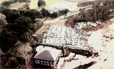
J. Lyle Bayless (former owner of the salt mine before selling it to the Diamond Crystal Mining Co.) watched these events from his lake front home. Soon after the police ordered Bayless from his house it dropped 28 feet into the widening lake. Following the house, portions of a newly constructed conservatory dropped into the lake. Nearby the ventilation shafts on the mine started to geyser muddy water 200 feet into the air. By 2:30 in the afternoon the newly enlarged lake was virtually empty.

Figure 3. The Bayless home and Conservatory after they collapsed into the lake.
No loss of live was attributed to this accident due to the safety practices of the miners. It took two days for the considerably deeper lake to refill with gulf water. Nine of the 11 barges that sank eventually resurface. Presently the only part of the Bayless residence that can be seen is the chimney sticking out of the water. Recently, gas bubbles are starting to come to the surface of the lake from the location of the well.
There is no doubt that the water in the borehole somehow allowed water to enter the mine. But why did this happen? The Diamond mining Co. learned of Texaco's well through a permit Texaco filed with the Army Cops of Engineers to deepen the Delcambe canal. This permit said nothing about the direction of the drill hole, nor its final depth. But the well coordinates placed it directly over the 1300 foot level of the mine. Apparently, no one at the Diamond Crystal Mining Co. checked the coordinates of the well and no one at Texaco contacted the mine.
Please check out the Video clip from the History Channel about the Engineering accident
Sources:
I obtained most of this information from the "Live Oak Gardens/A place of Peace and beauty" booklet by Diana Moore written in 1991 ( Available in the gift shop ).
I also received some of this information by speaking to the folks at the Welcome Center to the Gardens.
To log this Earth Cache:
To get credit for this cache, you must answer two of the three questions from the information that can be found near the back wall / hallway within the Welcome Center. Please send me the answer to the questions, do not post in your find.
1. On the second page of the black folder, there is a newspaper article "Drilling rig breaks into salt mine, draining lake" What was the name of the newspaper?
2. Near the back of the black folder, What is the cave-in emitting? ( It was last reported on the third to last page ).
3. There is a map on the upper right hand portion of the wall above the black folder. How far was the rig located from shore.
Please post pictures if you take some
I hope you learned something along the way.
Help thy Neighbor during times of trouble.
Take care, and keep on caching,
Oilman