

Come on a journey to remember and commemorate
the history and travels of Captain John
Smith!
Over four
hundred years ago, Englishman John Smith and a small crew set out
in an open boat to explore the Chesapeake Bay. Between 1607 and
1609 Smith mapped and documented nearly 3,000 miles of the Bay and
its rivers. Along the way he visited many thriving American Indians
communities and gathered information about this “fruitful and
delightsome land.” In December 2006 the U.S. Congress
designated the routes of Smith’s explorations of the
Chesapeake as a national historic trail—the first national
water trail.
Are you ready
to follow in the wake of Captain John Smith? Visit sites along the
National Historic Trail and learn about the native cultures and the
natural environment of the 17th-century Chesapeake through the
Captain John Smith Chesapeake Geotrail. The Trail provides
opportunities for you to experience the Bay through the routes and
places associated with Smith’s explorations. Caches will be
located in museums, refuges, parks, and towns in Virginia, Maryland
and Delaware along the rivers and creeks that Smith and his crew
explored four centuries
ago.
The Captain
John Smith (CJS) Geotrail launched June 4, 2011 with over 40 caches
within Maryland, Virginia and Delaware. A trackable geo coin will
be awarded to the first 400 geocachers, while supplies last, for
locating at least 15 CJS caches. To be eligible for the coin,
geocachers must download a passport from either the CJS Geotrail or Maryland Geocaching Society website.
Geocachers must find and log at least 15 finds, record the code
word from each cache on their passport and post a picture of
themselve at each cache location. After discovering the 15 required
caches, geocachers may have thier passports validated in person or
via mail at the National Park Service, Chesapeake Bay Office
located at 410 Severn Ave, Suite 314, Annapolis, MD 21403. Please
refer to the passport for complete validation instructions.
Participating in the CJS geotrail is fun and we
hope that many people join in. However, it is not a requirement for
logging your find on this cache once you find the container.
You are seeking a traditional hide. A Lock & Lock, camo'd and
stocked with a variety of items. This park is only open sunrise to
sunset. Please no night caching!
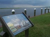
Vienna Waterfront Park is now known as
Emperor’s Landing. The town of Vienna is cited close to the
Nanticoke Indian town of Kuskarawaok, later known as Chicone. The
Nanticoke Indian paramount chief’s house was at Kuskarawaok,
and it is likely that Smith visited the leader’s house.
On June 10, 1608, Smith and his crew of 14 on the Discovery Barge,
a 30-foot shallop outfitted with sails and oars, were approached by
four Nanticoke Indian men. Smith treated them favorably and they
returned with more people to engage in trading. Soon, hundreds had
gathered. Smith referred to their furs for trade as the finest
available in the Chesapeake. Smith and a bodyguard may have been
taken by canoe to Chicone creek and on to the leader’s house
at Kuskarawaok, a palisaded town. From there, a quick exploration
was made of the Nanticoke River upstream into what is now Delaware.
Smith’s important map and journal indicate that he marked the
extent of his Nanticoke exploration with a brass cross.
Vienna’s waterfront park was named “Emperor’s
Landing” in honor of the Nanticoke Indians who lived here.
Descendants believe that Emperor’s Landing was used as a
ceremonial feasting ground. The town of Vienna is planning a
Captain John Smith Nanticoke Discovery Center to complement
Emperor’s Landing and provide a center for scientific
exploration, economic development, and river heritage
tourism.
A Chesapeake Bay Gateways and Watertrails Network site,
Emperor’s Landing along the waterfront in Vienna offers
visitors a riverwalk, floating docks, bayscapes landscaping and
marsh creation. The town works closely with the Maryland Department
of Natural Resources for conservation-focused development.
Emperor’s Landing was once the site of industrial properties
and its transformation echoes the town’s vision for its
future: “to link and protect cultural, historic and
recreational
opportunities”.

Thanks to The 8
Searchers for helping with this hide and to the Maryland
Geocaching Society for assisting with this
project!