An Artesian Well in Riverside Park EarthCache
An Artesian Well in Riverside Park
-
Difficulty:
-

-
Terrain:
-
Size:  (not chosen)
Please note Use of geocaching.com services is subject to the terms and conditions
in our disclaimer.
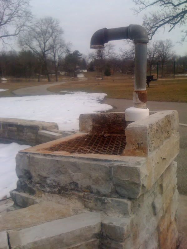
Welcome to the artesian well located in Riverside Park along the
Kiwanis Trail.
A well whose source of water is a confined (artesian) aquifer. The
water level in artesian wells stands at some height above the water
table because of the pressure (artesian pressure) of the aquifer.
The level at which it stands is the potentiometric (or pressure)
surface of the aquifer. If the potentiometric surface is above the
land surface, the well is a flowing artesian well.

An Artesian Well is a deep drilled well through which water is
forced upward under pressure. The water in an artesian well flows
from an aquifer, which is a layer of very porous rock or sediment,
usually sandstone, capable of holding and transmitting large
quantities of water. The geologic conditions necessary for an
artesian well are an inclined aquifer sandwiched between impervious
rock layers above and below that trap water in it. Water enters the
exposed edge of the aquifer at a high elevation and percolates
downward through interconnected pore spaces. The water held in
these spaces is under pressure because of the weight of water in
the portion of the aquifer above it. If a well is drilled from the
land surface through the overlying impervious layer into the
aquifer, this pressure will cause the water to rise in the well. In
areas where the slope of the aquifer is great enough, pressure will
drive the water above ground level in a spectacular, permanent
fountain.
The artesian well at the south end of Riverside Park was drilled in
1939. The well is drilled to a depth of 940' and cased with pipe to
a depth of 280'. It provided uninterrupted drinking water for the
community for over 50 years.In the 1990's its flow became sporadic
in nature. In 2007, the city had the well televised and determined
that there is no blockage or damage to the well pipe. They have
concluded that deep well water consumption by Janesville's
municipal wells along with regional usage by other communities have
reduced the ground pressure which forces the water out of the
well.
In order to log this cache you must email the owner with the
following information: flow of the well in gal/min, shape and
dimensions of basin. If water is not flowing please also indicate
the 'Marker #' located near GZ. (Optional) - please try to include
a photo of yourself visiting the site.
Many thanks to Tom Presny, Janesville Parks Director for the
information and help with this EarthCache.
Additional Hints
(No hints available.)