For those, who can't await the questions /
Za one koji ne mogu dočekati pitanja /
Für all diejenigen, die die Fragen nicht abwarten können:
-
Of which rock are the tables at the picnic area at the cache coordinates built and how many different varieties of these rocks have been used?
-
In what year was the tunnel completed, that was opened to traffic in 2009?
To get the permission to log send an e-mail with your GC name in the subject and a valid return address to:
<Rock>.<Number Varieties>.<Year of completion>@googlemail.com
For example marble.2.2010@googlemail.com (these details are of course not accurate).
If your information is accurate, the log permission will be returned within a vew minutes.
I would appreciate a picture of you at the picnic area attached to your log.
-
Od kojih su stijena stolovi na prostoru za piknik, koji se nalazi na koordinatama cache-a i koliko je različitih stijena korišteno?
-
Koje je godine zavšen tunel, koji je 2009-e godine pušten u promet?
Da bi dobili dozuvolu za log, pošaljite e-mail sa svojim korisničkim imenon na Geocaching.com, te vašom e mail adresom za odgovor na:
<naziv stijene na engleskom jeziku>.<broj različitih stijena>.<godina završetka gradnje>@googlemail.com
Npr. marble.2.2010@googlemail.com (ovi podaci, naravno, nisu točni).
Ako su Vaši odgovori točni, za nekoliko minuta dobit ćete mail s dozvolom za logiranje. Ukoliko ne dobijete odgovor, Vaši odgovori nisu točni.
Fotografije u Vasm log-u su uvijek dobro došle.
-
Aus welchem Gestein sind die Tische des Rastplatzes an der Cache-Koordinate und wieviele unterschiedliche Sorten dieses Gesteins wurden verwendet?
-
In welchem Jahr erfolgte die Fertigstellung der 2009 freigegebenen Tunnelröhre?
Um die Log-Freigabe zu erhalten schicke eine E-Mail mit Deinem GC-Namen im Betreff und einer gültigen Absender-Adresse an folgende Adresse:
<Gestein (Englisch)>.<Anzahl Sorten>.<Jahr der Fertigstellung>@googlemail.com
also z.B. marble.2.2010@googlemail.com (diese Angaben stimmen natürlich nicht).
Wenn Deine Angaben stimmen erhältst Du umgehend die Log-Erlaubnis, kommt diese nicht innerhalb weniger Minuten, so hast Du noch irgendeinen Fehler in Deinen Antworten.
Besonders freue ich mich, wenn Du deinem Log noch ein Foto von Dir am Rastplatz anhängst.
And now: the facts / A sada: činjenice / Und nun: die Fakten
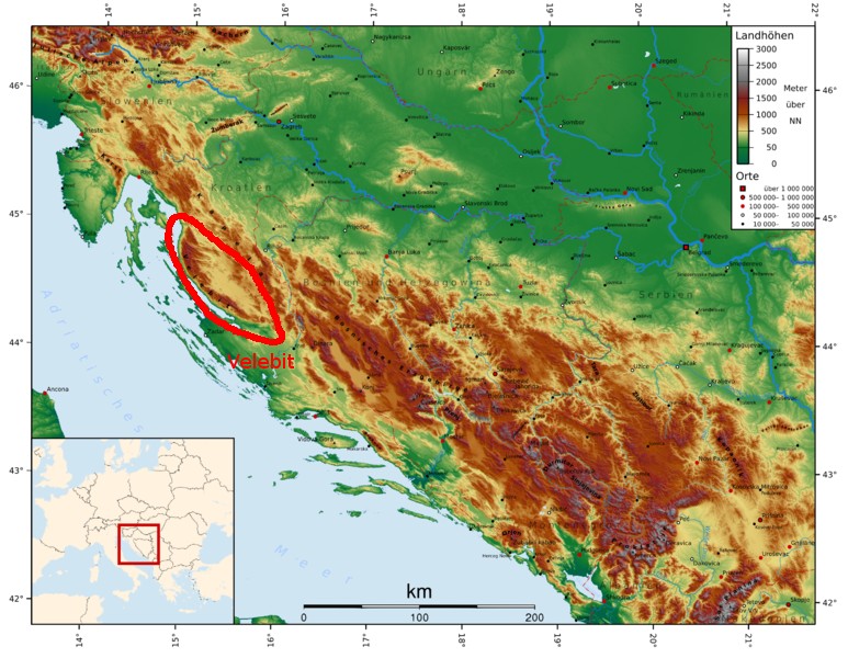 |
The Velebit mountains are 145km long and 10 to 30km wide. They are the longest part of the Dinaric mountain system between the Alps in the north and the Albanian Alps in the south. It is added to the Adriatic coastal belt of the Dinaric mountain folds, which are characterized by steeply rising, low-water coastal karst areas. The highest peak is Vaganski Vrh with 1757 m.
Velebitski masiv je dugačak 145 km i širok od 10 do 30 km. To je najduži dio planinskog sustava između Alpa na sjeveru i Albanskih alpa na jugu i pripada Dinarskom planinskom masivu. Najviši vrh Velebita je Vaganski vrh sa 1.757 m.
Das Velebit-Gebirge ist mit 145km Länge und 10 bis 30km Breite der längste Bestandteil des dinarischen Gebirgssystems zwischen den Alpen im Norden und den albanischen Alpen im Süden. Es wird zum adriatischen Faltengebirgsgürtel der litoralen Dinariden gezählt, welche sich durch steil aufragende, wasserarme Küstenkarstgebiete auszeichnen. Die höchste Erhebung ist der Vaganski Vrh mit 1.757 m.
|
|
Since the Devonian (416 to 359.2 MBP), particularly in the Jurassic (199.6 to 145.5 MBP) and the Cretaceous Period (145.5 to 65.5 MBP), up to modern times were carbonate and dolomite sediments deposited in the lowering basin, which now reach a thickness of about 4km. The collision of African-Arab with the Eurasian plate since the Oligocene (33.9 to 23.03 MBP) folds the mountains (like the Alps). During the Quaternary ice ages, the Velebit mountain range was largely free of ice, so that their influence was low on the geological processes.
Od Devona (416 do 259,2 MG), osobio u juri(199,6 – 145,5 MG) i kredi (145,5 – 65,5 MG) sve do modernih vremena u ovom se bazenu nakupljaju karbonatni i dolomitni sedimenti, koji danas dostižu debljinu i do 4 km. Zbog sudaranja Afričko-Arapske i Europske kontinentalne ploče u olgocenu (33,9 – 23.03 MG) uzdižu se nabori Velebita (kao i Alpe). U vrijeme ledenog doba, Velebit večinom nije bio pokriven ledom, tako da njegov utjecaj na geološke procese i nije bio velik.
Seit dem Devon (416 bis 359,2 MBP), insbesondere im Jura (199,6–145,5 MBP) und der Kreidezeit (145,5–65,5 MBP), bis in die Neuzeit wurden in dem sich absenkenden Becken karbonatische und dolomitische Sedimente abgelagert, die heute eine Mächtigkeit von über 4km erreichen. Durch die Kollision der afrikanisch-arabischen mit der eurasischen Platte seit dem Oligozän (33,9 bis 23,03 MBP) faltet sich das Gebirge (wie auch die Alpen) auf. Während der Eiszeiten im Quartär war das Velebit-Gebirge weitgehend eisfrei, so dass deren Einfluss auf die geologischen Prozesse gering war.
|
 |
 |
Like the entire Dinaric mountain system, the Velebit mountain range consists mainly of limestone. Limestone is very porous and cracked the one hand, but also very hard and resistant to erosion. Water flows through the pores and cracks and chemically decomposes the limestone. The water, together with the carbon dioxide in air or sulfur compounds of the soil acids dissolve the calcium carbonate of the limestone. In this way, the enlarged pores and cracks become underground passageways. These events are the basis of karstification, which here in the outer Dinarides occurs particularly clear in appearance.
Kao i cijeli Dinarski planinski sutav, Velebit se sastoji uglavnom od vapnenca. Vapnenac je vrlo porozna i ispucala stijena, ali je s druge strane vrlo tvrd i otporan na eroziju. Voda protiče kroz pore i pukotine te kemijski razgrađuje vapnenac. Pri proticanju kroz kamen voda reagira s ugljičnim dioksidom iz zraka ili sumpornim spojevima u tlu, te stvara kiseline koje razgrađuju vapnenac. Na taj način se pore i pukotine povečavaju te tvore podzemne hodnike. Ovi događaji su temelj za okršavanje, što je posebno vidljivo na vanjskim Dinaridima.
Wie das gesamte Dinarische Gebirgssystem besteht auch das Velebit-Gebirge überwiegend aus Kalkstein. Kalkstein ist einerseits sehr porös und rissig, andererseits aber auch sehr hart und resistent gegenüber Erosion. Wasser fließt durch die Poren und Risse und zersetzt den Kalkstein chemisch. Dabei bildet das Wasser zusammen mit dem Kohlendioxyd der Luft oder Schwefelverbindungen des Bodens Säuren, die das Kalziumkarbonat des Kalksteins auflösen. Auf diese Weise werden die Poren und Risse vergrößert zu unterirdischen Gängen. Diese Vorgänge sind die Grundlage der Verkarstung, die hier in den äußeren Dinariden besonders deutlich in Erscheinung tritt.
|
|
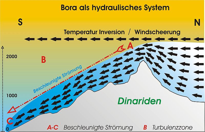
The Velebit mountain range is the source of up to Italy acting strong gusty, cold and dry Bora (Bura) winds. They form when cold continental air from the east reach the Adriatic Sea at the western slopes of the Velebit mountain range. The winds last in summer a few hours, in winter up to 14 days. The gusts reach particularly in transitional periods of spring and autumn speeds of more than 200km/h. For this reason, the A1 motorway between the Maslenica bridge and the Sveti Rok Tunnel is closed occasionally to prevent accidents. Here are unique in the world wind barriers tested, intended to permit traffic even in stronger winds.
Velebitsko gorje je mjesto nastanka Bure, hladnog i suhog vjetra s vrlo jakim udarima, koji seže sve do Italije. Vjetrovi nastaju iz hladnih kontinentalnih vjetrova na zapadnim padinama Velebitskog gorja. Vjetrovi ljeti pušu nekoliko sati, dok zimi mogu puhati i do 14 dana. U prijelaznom vermenu, u proljeće i jesen, udari Bure dostižu brzine i preko 200 km/h. Zbog ovih udara vjetra je povremeno zatvorena i auto-cesta A1 izmedju Masleničkog mosta i tunela Sveti Rok, kako bi se sprijećile nesreče. Ovdje se testiraju i jedinstvene barijere protiv naleta vjetrova koje bi trebale omogućiti promet i kod jakih vjetrova.
Das Velebit-Gebirge ist der Entstehungsort der bis nach Italien wirkenden stark böigen, kalten und trockenen Bora- (Bura-) Fallwinde. Sie entstehen, wenn kalte Kontinentalluft aus dem Osten an den Westhängen des Velebit-Gebirges die Adria erreicht. Die Winde dauern im Sommer wenige Stunden, im Winter dagegen bis zu 14 Tage an, die Böen erreichen insbesondere in den Übergangszeiten von Frühling und Herbst Geschwindigkeiten von über 200km/h. Aus diesem Grund wird die Autobahn A1 zwischen der Maslenica-Brücke und dem Sveti-Rok Tunnel gelegentlich gesperrt, um Unfälle zu vermeiden. Hier werden weltweit einzigartig Windbarrieren getestet, die den Verkehr auch bei stärkeren Winden ermöglichen sollen.
|
 |
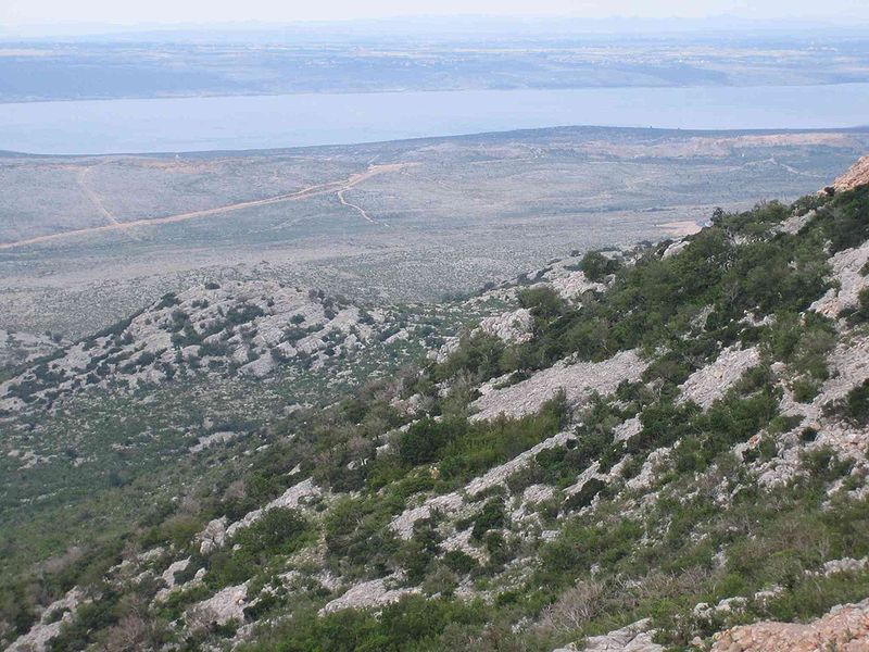 |
The eastern slopes of the Velebit Mountains are largely forested. The coastal side, however, is of very sparse vegetation. A characteristic feature of the landscape on the west side are bright limestone rocks , because the lack of bare soil. Due to the dryness of the Bora wind this side has very little water. Thus, on the basis of vegetation particularly clear, that the mountains separate two climate zones from each other, the mountain climate in the interior to the east and the Mediterranean climate on the coast in the west. The entire Velebit mountain is now a national park and protected area.
Istočne padine Velebita su obrastene gustim šumama, dok je na obalnoj strani vegetacija vrlo oskudna. Karakteristična značajka krajolika na zapadnoj strani su svijetle vapnenačke stijene, vidljive zbog nedostatka plodnog tla. Zbog suhoće Bure ova strana oskudijeva vodom. Na temelju vegetacije je jasno vidljivo da ovo gorje razdvaja dvije klimatske zone, planinsku klimu u unutrašnjosti i mediteransku klimu na obali. Cijelo područje Velebita danas je nacionalni park i zastičeno područje.
Die Osthänge des Velebit-Gebirges sind überwiegend dicht bewaldet, die Küstenseite ist dagegen sehr spärlich bewachsen. Charakteristisch für das Landschaftsbild der Westseite sind die mangels Bodenbildung kahlen, hellen Kalksteinfelsen. Durch die Trockenheit der Bora-Fallwinde ist diese Seite sehr wasserarm. So wird anhand der Vegetation besonders deutlich, dass das Gebirge zwei Klimazonen von einander trennt, das Gebirgsklima im Landesinnern im Osten und das Mittelmeerklima an der Küste im Westen. Das gesamte Velebit-Gebirge ist heute ein Nationalpark und somit geschützt.
|
|
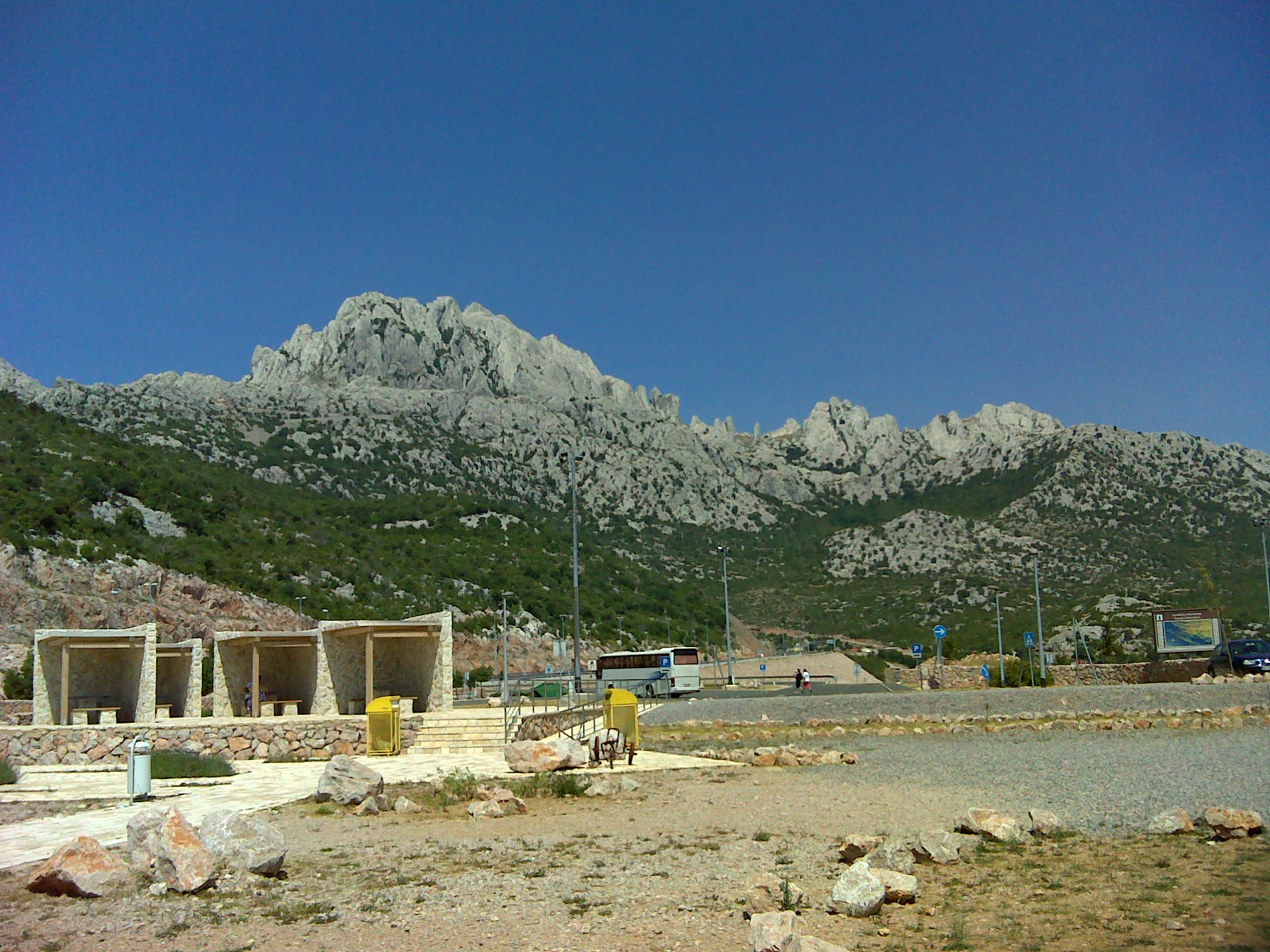
The Sveti Rok Tunnel connects on a length of 5.7 km the east and west side of the Velebit mountain range between the villages of Sveti Rok in the east and the west Maslenica. The construction was begun in 1993 and it was even promoted in the war. The first tunnel was opened to traffic in 2003, when both tubes were finished, the second tube in 2009. During the building large cave systems were crossed, which made the construction very complicated. After the Mala Kapela Tunnel Sveti Rok Tunnel is the second longest road tunnel in Croatia. The safety of both tunnels are among the most modern in Europe, so they are always rated very well in the relevant tests.
Tunel Sveti Rok, svojom dužinom od 5,7km spaja istočnu i zapadnu stranu Velebita između mjesta Sveti Rok na istoku i Maslenice na zapadu. Gradnja je započeta 1993 godine, te je nastavljena unatoč ratnim zbivanjima. Prva cijev tunela je puštena u promet 2003 godine, a druga cijev po svom završetku, 2009 godine. U tijeku gradnje prolazilo se i kroz nekoliko velikih špilja, što je samu gradnju činilo vrlo kompliciranom. Poslije tunela Mala Kapela, tunel Sveti Rok je drugi po dužini tunel u Hrvatskoj. Sigurnosni sistemi u oba tunela ubrajaju se u najmodernije u Europi, pa tuneli uvijek dobro prolaze na testovima.
Der Sveti-Rok Tunnel verbindet auf einer Länge von 5,7km die Ost- und Westseite des Velebit-Gebirges zwischen den Ortschaften Sveti Rok im Osten und Maslenica im Westen. Mit dem Bau wurde 1993 begonnen und er wurde sogar in den Kriegszeiten vorangetrieben. Die erste Tunnelröhre wurde 2003 für den Verkehr freigegeben, als beide Röhren bereits fertiggestellt waren, die zweite Röhre im Jahr 2009. Während des Baues wurden stellenweise große Höhlensysteme durchquert, was den Bau besonders anspruchsvoll gestaltete. Nach dem Mala Kapela Tunnel ist der Sveti Rok Tunnel der zweitlängste Straßentunnel Kroatiens. Die Sicherheitssysteme beider Tunnel gehören zu den modernsten Europas, und so schneiden sie in den einschlägigen Tests stets sehr gut ab.
|
 |
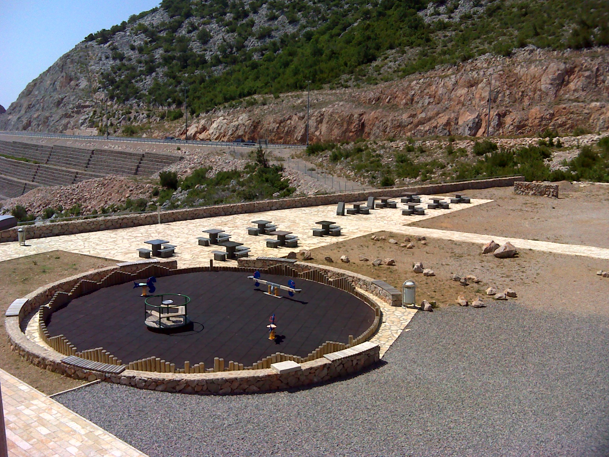 |
The location at the picnic area at Sveti Rok Tunnel offers a very nice overview of the bare peaks of the Velebit mountains, over its western flank and the flat coastal land with the Strait of Maslenica, to the islands. The tables and benches of the picnic area invite to a small break of the trip, and there may also the above questions to this cache be answered...
S lokacije na odmorištu Sveti Rok pruža se prekrasan pogled na ogoljele vrhove Velebita, a na zapadnoj strani pogled na ravnu obalu i Masleničku dragu te otoke koji leže ispred nje. Stolovi i klupe na odmorištu pozivaju na mali odmor od naporne vožnje. Ovdje se također mogu pronači odgovori na gornja pitanja.
Der Standort auf dem Rastplatz am Sveti Rok Tunnel bietet einen sehr schönen Überblick von den kahlen Gipfeln des Velebit-Gebirges über dessen Westflanke und das flache Küstenland mit der Meerenge von Maslenica bis hin zu den vorgelagerten Inseln. Die Tische und Bänke des Rastplatzes laden zu einer kleinen Pause von der Fahrt ein, und hier können auch gleich die oben stehenden Fragen beantwortet werden...
|
Now I wish you a relaxing break, a lot of success in answering the questions and then of course a good trip!
Želim Vam opustajuću pauzu i puno uspjeha u traženju opdgovora, te naravno ugodan nastavak vožnje.
Nun wünsche ich Dir eine erholsame Pause, viel Erfolg bei der Beantwortung der Fragen und danach natürlich weiterhin eine gute Fahrt!
|
All pictures were either shot by the author or acquired from Wikipedia, they are published under the / Sve slike su bile pucao u sebe ili stecena iz Wikipedia, oni su pod / Alle Bilder wurden entweder selbst fotografiert oder von Wikipedia übernommen; sie stehen unter der "GNU Free Documentation License".
Special thanks to GaAlOz for improving the Croatian part of the text!
|