Named in honor of Capt. George M. Wheeler of the Wheeler Survey, the area was designated a National Monument from 1908 until 1950. In 1950, it was decided that Wheeler was too remote and had too few visitors, so the property was transferred to the Forest Service and largely ignored. The Forest Service renamed the area Wheeler Geologic Area and incorporated it into the new La Garita Wilderness when that was designated in 1964. It is now administered by the Rio Grande National Forest which provides a higher level of protection for the natural landscape.
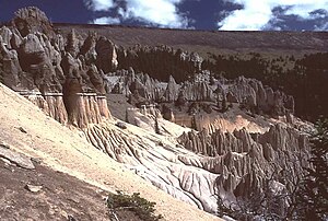
The Wheeler Geologic Area is a highly eroded landscape comprised of an outcropping of layers of volcanic tuff (ash), located in the La Garita Mountains of Mineral County, in southern Colorado. The ash is the result of eruptions from the La Garita Caldera. Individual particles of this tuff vary from dust flakes to blocks two and three feet across. This surface layer is not compacted or cemented together in any way, so the landscape readily erodes. We are left with a unique badlands of spires and pinnacles with steep slopes that make this area almost impossible to traverse. Please stay on the designated trails.
Individual particles of this tuff vary from dust flakes to blocks two and three feet across. This surface layer is not compacted or cemented together in any way, so the landscape readily erodes. We are left with a unique badlands of spires and pinnacles with steep slopes that make this area almost impossible to traverse. Please stay on the designated trails.
Directions:
Please keep in mind that this is at least a 6 hour trip off any paved road by car, possibly longer. Bring adequate supplies, check to make sure the roads are passable (only accessible by road about 4 months out of the year, usually July - October), and pack out what you take in.
From Creede go 7.3 miles southeast on Highway 149 to Pool Table Road (Forest Service road #600). Or: coming from the south: take 149 north from South Fork for 14.3 miles to the junction with Pool Table Road. From the turn onto Pool Table Road, travel northeast approximately 9.9 miles. This portion is 2WD. You'll come to a sawdust pile marking the remains of the old Hanson's Sawmill. If you do not have a high clearance 4WD vehicle (leave your Subaru), you can choose to park here and hike the well-marked trail or if your vehicle is capable, continue on the 4WD road that winds northeast and then northwest around Pool Table Mountain for just under 14 miles to the boundary fence of the Wheeler Geologic Area. The Forest Service warns that only high clearance 4WD vehicles have a chance on this road and it is impassable when wet.
On the hiking approach, the trail wanders through forested areas for 2.1 miles before dropping down to East Bellows Creek (the boundary of the La Garita Wilderness). In fall, fording the creek is easy but spring runoff can make this ford nearly impossible. The obvious trail from here leads into a series of canyons. At each canyon bifurcation, stay left. At about 3 miles (from the sawmill), the trail climbs out of the canyons and rises steadily through open parks and stands of trees until reaching treeline about a mile later. From here, the well-worn trail crosses high meadows, passing the odd pole marker along the way, until you reach the junction with the 4WD road at 5.7 miles (from the sawmill). The last 1.1 miles to the boundary of the Wilderness Area follow this road to the Wheeler Geologic Area trailhead. Along the way, you will gain 1,140 feet and lose 1,050 feet in elevation (which you will do again on your way out) in this 6.8 mile walk.
From the Geologic Area trailhead it's 0.4 miles to the trail junction with the Wheeler Geologic Area Loop Trail. From this trail junction the 2.8 mile Loop Trail goes straight ahead or to the left. The left route takes you to the most photographed spot more quickly, but the trail is a loop, so you get there either way. There are observation points along the way (even a bench at one) and the high point of the trail is at 11,900' (900' above the parking area) where the Loop Trail meets the Half Moon Pass Trail about halfway around the loop from the beginning trailhead.
To log this EarthCache:
To log a find, go to both the parking area and the designated coordinates above and find the answers to the following questions and email them to me:
1) How long ago did the most recent volcanic activity begin and how long did it last?
2) How thick was the most recent ash layer?
3) According to the signs, what is a geologic formation created by the forces of erosion?
4) According to the signs, what is more dense than ash and resists erosion? Give me an example of where you would find this substance in the Wheeler Geological Area.
This area is very picturesque, so any pictures you wish to include in your log (except any containing any of the answers above) are more than welcome.