Kanaka Creek EarthCache
This cache has been locked, but it is available for viewing.
-
Difficulty:
-

-
Terrain:
-

Size:  (not chosen)
Please note Use of geocaching.com services is subject to the terms and conditions
in our disclaimer.
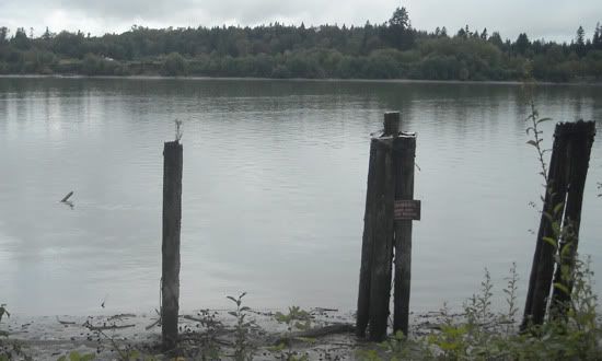
Nestled over to the side of the Lougheed highway in the outskirts
of Maple Ridge, past the train tracks, is Kanaka Creek regional
park, which covers most of the course of the river. The creek's
headwaters are located in the southeast corner of Golden Ears
provincial park.
The regional park management has provided several informative signs
at the mouth of the creek highlighting the historical precedence,
ecological importance, and fluvial processes that shape the area
into its colorful greens and browns. This earthcache will hopefully
facilitate cachers and their families and friends to stopover and
learn something they may not have known about this creek and earth
science in general.
 Kanaka Creek: A 15km long tributary of the Fraser River located in
Maple Ridge, which is subjected to perpendicular tidal forces. A
regional park has been created along the corridor of the creek,
which includes a fish hatchery and some interesting waterfalls.
Fishing has become a popular activity at the confluence with the
Fraser.
Kanaka Creek: A 15km long tributary of the Fraser River located in
Maple Ridge, which is subjected to perpendicular tidal forces. A
regional park has been created along the corridor of the creek,
which includes a fish hatchery and some interesting waterfalls.
Fishing has become a popular activity at the confluence with the
Fraser.
Kanaka Creek, being a late-stage tributary of the Fraser, does not
have a great gradient. Rather, its headwaters start on a broad
ridge bordering the southeast corner of Allouette Lake, elevation
approx. 900m, making its grade only 6%. This low grade provides the
meandering characteristics of the river in the latter half of its
course through Mission and Maple Ridge.
Around 49° 12.615'N 122° 31.445'W there begins a change in
underlying material, as a seam of volcanic rock that was once
connected to Grant Hill has been revealed by the creek's erosion of
Pleistocene glacial till. This has created a step-pool waterfall
phenomena named Cliff Falls. Due to this rougher patch, Kanaka
Creek deposits its heavier sediment load of gravel and heavy sand
behind the falls, and continues on with only a lighter bedload of
light sand, silt and clay. This lighter material deposited towards
the creeks mouth at Maple Ridge, and facilitates the formation of
very sinuous meanders, and the possibility of future oxbow
lakes.
Wetlands comprise the final kilometer stretch, where unique
insects, aquatic organisms, and avian life flourish due to filtered
nutrients and toxins. This floodplain contains soil that is
comprised mainly of light sand, silt and clay which was mentioned
previously. This composition is perfect for absorbing and holding
lots of water which creates a seasonal marsh-like wetland. Only
plants that don't mind wet feet (flooded roots) can survive
here.
 Fraser River: The longest river in British Columbia, and the tenth
longest in Canada. Named for 19th century pioneer Simon Fraser, the
river is nearly 1400 kilometers long and dumps an estimated 20
million tons of sediment into the Straight of Georgia every
year.
Fraser River: The longest river in British Columbia, and the tenth
longest in Canada. Named for 19th century pioneer Simon Fraser, the
river is nearly 1400 kilometers long and dumps an estimated 20
million tons of sediment into the Straight of Georgia every
year.
Important Fluvial
Terms
Capacity - A measure of the total load of material a stream
can move in all transport methods.
Cut bank - The outside and downstream side of the meander.
Faster water velocity flows there.
Discharge -The volume of water flowing past a given
point/cross section in a specified length of time. Usually measured
as meters/second.
Estuary - Where the mouth of a river broadens into the sea
and within which the tide ebbs and flows, leading to an intermixing
of saline and freshwater, Estuaries are usually zones of
deposition, especially if the river discharges more sediment than
can be moved by tidal currents or wave action.
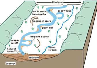 Floodplain - A broad, fairly flat expanse
of land covered with sediment around a stream channel. An area into
which the stream spills over during floods.
Floodplain - A broad, fairly flat expanse
of land covered with sediment around a stream channel. An area into
which the stream spills over during floods.
Load - The total quantity of material that a stream
transports by all methods (traction, saltation, suspended, and
dissolved).
Meander - Streams don’t flow in straight lines, they
erode old banks and create new banks, and thus bends form in the
streams. Meanders are curves in a stream (or river).
Meander scars - A cut-off in which the former river channel
or oxbow lake has been partially infilled by slumping of the
channel walls and by vegetation growth. The meander form is usually
still distinguishable.
Oxbow lake - Crescent-shaped lake occurring on a river
floodplain, having once been part of a river meander that has been
cut through and abandoned by lateral erosion of the cut banks at
the meander neck.
Point bar - Sediment deposited on the insides of meanders,
due to slow-down in water velocity there.
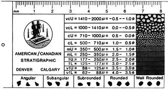
Sediment grain size - Various sizes of solid particles and
grains of rock that have been transported and deposited by varying
means, but not in solution. Below are broad classifications of
size, in which there are further minute classifications. In order
of individual grain size from smallest – largest:
- Clay – less than 0.004mm
- Silt – greater than 0.004mm but less than 0.0625mm
- Sand – greater than 0.0625mm but less than 2mm
- Gravel/Pebble – greater than 2mm but less than 64mm
- Cobble – greater than 64mm but less than 256mm
- Boulder – greater than 256mm
Sinuosity - Stream channel length divided by length of
meander belt axis or by valley length. Sinuosity of 1.5 is dividing
point between straight and meandering.
Tidal bore - A tidal phenomenon in which the leading edge of
the incoming tide forms a wave that travels up a river against the
direction of the river current. It is a true form of a tidal wave
and not to be confused with a tsunami.
Watershed - The land surface which is drained by a unitary
river system. Its perimeter is marked by a drainage divide, which
is usually an encompassing height of land.
Wetland - An area that has developed specially adapted
vegetation due to long dominance by water and saturated soil.
Wetland organic & inorganic processes are largely controlled by
static or flowing, brackish or saline water. Wetlands are
considered the most biologically diverse of all ecosystems,
consisting of a unique plethora of animal, plant and aquatic
organisms.
Logging the Earthcache:
In order to claim this earth-cache, please email Vadrosaul (via the
profile link at the top of the page) with answers to the following
questions. Although it is optional, pictures of you, your group at
the earthcache site, and the surrounding landscape would be
appreciated:
1. From the posted coordinates, determine which way Kanaka Creek is
flowing, towards the head or the mouth, and deduce why it is
flowing that way.
2. How long do you think it will take to erode the cut bank and
create an oxbow lake here?
3. From the Fraser viewpoint waypoint, estimate how wide the Fraser
River is at this point. How much of British Columbia does the
Fraser drain?
4. What mountain signifies the start of the Fraser Rivers'
headwaters? What is unique about that mountain?
5. Proceed to Cliff Falls waypoint that's listed. Answer the
following (referring to the step-pool waterfall formation): How
many steps and how many pools do you see here? What's the average
length of the pools?
References
John B. Whittow -
Dictionary of Physical Geography
Dr. Johannes Koch - Fluvial Processes &
Landforms
Metro Vancouver -
Kanaka Creek Regional Park
Metro Vancouver -
Kanaka Creek Management Plan
Geological Survey of Canada - Vancouver's
Landscape: Fraser River
Fraser Basin Council - Fraser River
Basin
Slaymaker, O. - Implications of the Processes of Erosion &
Sedimentation for sustainable development in water management in
the Fraser River System. Vol. 1, U. B. C., 1991 (FL).
Additional Hints
(No hints available.)
Treasures
You'll collect a digital Treasure from one of these collections when you find and log this geocache:

Loading Treasures