 |
Deutsche
Version (English version below): |
Der
"Eifelgarten" ist Teil der Landesgartenschau Leverkusen. Der
Garten, der sich an obiger Koordinate befindet, soll auf die
Schönheiten und Regionen der Eifel aufmerksam machen. Hierzu dienen
die Regionen „Vulkaneifel“, „Kalkeifel“ und
„Nordeifel“. Jede einzelne Region wurde mit
charakteristischen Gestaltungselementen, Bepflanzungen und
entsprechenden Schau- und Erklärungstafeln dargestellt. Im
folgenden finden sich einige Hintergrundinformationen und
Ergänzungen zu den geologischen Besonderheiten, die sich im
Eifelgarten finden lassen und dort erklärt sind:
Die
Geologie der Eifel
Der
geologische Untergrund besteht in der Eifel wie in den anderen
Landschaften des Rheinischen Schiefergebirges überwiegend aus
Schiefer, Kalk- und Sandsteinen und Quarziten der Devonzeit. Bis
vor etwa 10.000 Jahren gab es in der Eifel starke vulkanische
Aktivität, Geologen unterteilen die Eifel daher aufgrund der
geologischen Begebenheiten eher in drei Naturräume; Schiefereifel,
Kalkeifel und Vulkaneifel. Die Krater, die bei der Explosion
vulkanischer Gase entstanden und sich teilweise mit Grundwasser
füllten, werden Maare genannt. Aus geologischer Sicht gilt die
Eifel noch immer als vulkanisch aktiv. Es wird angenommen, dass
sich unter der Eifel ein so genannter "Hot Spot" befindet.
Kennzeichen dieser vulkanischen Aktivität ist beispielsweise
austretendes CO2, zum Beispiel im Laacher See.
Die
Vulkaneifel
Als
"Repräsentanten" der Vulkaneifel finden sich in dem Garten zum
einen Basaltlava. Diese zeigt sich neben dem Pflaster in Form der
Basaltlavasäulen. Basalt ist ein basisches (kieselsäurearmes)
vulkanisches Ergussgestein. Es besteht vor allem aus einer Mischung
von Eisen- und Magnesium-Silikaten mit Olivin und Pyroxen sowie
kalziumreichen Feldspate (Plagioklas). Basalt ist das vulkanische
Äquivalent zum Gabbro (Plutonit), der die gleiche chemische
Zusammensetzung hat.
Basalt entsteht, wenn dünnflüssiges, kieselsäurearmes Magma an der
Erdoberfläche austritt und relativ schnell zu Basaltlava
erkaltet.
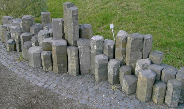
Basaltlavasäulen
Zum anderen
findet sich aus der Vulkaneifel die Vulkanlava. Vulkanlava ist die
Bezeichnung für eruptiertes Magma, das an die Erdoberfläche
ausgetreten ist. Lava ist ein vulkanisches Förderprodukt und gehört
zur Gruppe der Vulkanite. Andere vulkanische Förderprodukte sind
die Pyroklastika und die gasförmigen und damit flüchtigen
Volatilbestandteile (Kohlenstoffdioxid, Wasser, Schwefeldioxid,
Ammoniak, Edelgase), die das Magma durch Druckentlastung verloren
hat. Magmen treten vergleichsweise selten direkt an die Oberfläche
aus, da dazu erhebliche Kräfte erforderlich sind. Häufiger sind so
genannte Intrusionen, bei denen Magma in der Erdkruste
erstarrt.
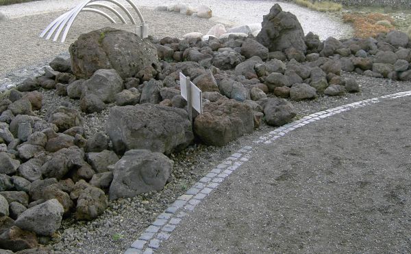
Vulkanlava
Die
Kalkeifel
Die
Kalkeifel ist geprägt durch ihr hohes Kalkvorkommen. Kalksteine
sind äußerst variable Gesteine; das betrifft sowohl ihre Entstehung
als auch ihre Eigenschaften, ihr Aussehen und ihre wirtschaftliche
Verwendbarkeit. Es gibt daher innerhalb der Geologie eine eigene
Fachrichtung, die Karbonatsedimentologie, die sich ausschließlich
mit der Entstehung und den Eigenschaften der verschiedenen
Kalksteintypen befasst.
Der Begriff Kalkstein wird sowohl in der Umgangssprache als auch in
der technischen und wissenschaftlichen Fachsprache anders
verwendet. Während man in der Wissenschaftssprache den Begriff
relativ umfassend verwendet und außer den stark verfestigten
Kalksteinen auch relativ mürbe Gesteine wie die Kreide den
Kalksteinen zurechnet, ist der Begriff in der Baustoffindustrie
eher auf stark verfestigte Kalke eingeschränkt. Weiterhin
bezeichnet man in der Naturwerksteinindustrie polierfähige
Kalksteine oft als Marmor, obwohl sie im geologischen Sinne keine
Marmore sind. Marmor gilt in den Geowissenschaften als metamorphes
Gestein.
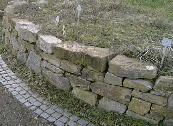
Kalksteinmauer
Um diesen
Earthcache zu loggen, erfülle bitte folgende Aufgaben (Du
brauchst nicht auf eine Logfreigabe zu warten, ich melde mich, wenn
etwas nicht stimmt):
- Messe den
Umfang einer Basaltsäule und die Höhe der Kalksteinmauer und
schicke mir das Ergebnis!
- Mache
bitte freiwillig ein Foto von dir im Eifelgarten an obiger
Koordinate. Falls du alleine bist, reicht auch ein Foto von deinem
GPS mit lesbaren Koordinaten.
Weitere
Infos zum Thema können auf folgendem Link gefunden
werden:
Wikipedia-Artikel über die
Eifel
 |
English
version: |
The
"Eifelgarten" is part of the "Landesgartenschau" Leverkusen. The
garden, which you find at the above coordinates, would like to
introduce you the beauty and the regions of the Eifel. Therefore
you find the regions „Vulkaneifel“,
„Kalkeifel“ and „Nordeifel“ as an example.
Each region is explained by different information tables and
visualized by typically botanical and geological characteristics of
the region. In the following you find additional information about
the geological sights you can find in the park. This will help you
to unterstand the information tables much better:
The
Geology of the Eifel
The Eifel is
a low volcanic mountain range in western Germany. It occupies parts
of southwestern North Rhine-Westphalia and northwestern
Rhineland-Palatinate.
The Eifel is bordered by the Moselle River in the south and the
Rhine in the east. In the north it is continued by the hills of the
High Venn (Hohes Venn), in the west by the Ardennes. (Ardennes and
Eifel are actually the same geological region. They are a single
volcanic field.)
In the Tertiary geological era, the Eifel was a site of extensive
volcanic activity. Some of the hills are volcanic vents. The lakes
of the regions are former volcanic craters (maars). The last
eruptions took place around 10 000 years ago. The volcanism of the
Eifel is caused by a hotspot, a place where hot material form deep
in the mantle rises to the surface. Research has shown that the
mantle plume is still active; the Eifel region is rising by 1-2 mm
per year. Historically, the Eifel volcanoes had inactive phases of
10 000 to 20 000 years between active phases, suggesting there is a
possibility of future eruptions.
The
"Vulkaneifel"
Basalt lava
is an important feature of the "Vulkaneifel". You find lots of
pillars of basalt lava in the garden. Basalt is a common gray to
black volcanic rock. It is usually fine-grained due to rapid
cooling of lava on the Earth's surface. It may be porphyritic
containing larger crystals in a fine matrix, or vesicular, or
frothy scoria. Unweathered basalt is black or gray.
Basalt magmas form by decompression melting of peridotite in the
Earth's mantle, a process discussed in the entry for igneous rocks.
The crustal portions of oceanic tectonic plates are comprised
predominantly of basalt, produced from upwelling peridotite in the
mantle below ocean ridges.
Pliny used the word basalt and it is said to have had an Ethiopian
origin, meaning a black stone.
The term basalt is at times applied to shallow intrusive rocks with
a composition typical of basalt, but rocks of this composition with
a phaneritic (coarse) groundmass are generally referred to as
dolerite (also called diabase) or gabbro.
Basalt
lava
Another
feature of the "Vulkaneifel" is the vulcano lava. Lava is molten
rock expelled by a volcano during an eruption. Magma is molten rock
below the earth's surface. Lava, when first exuded from a volcanic
vent, is a liquid at temperatures from 700 °C to 1,200 °C (1,300 °F
to 2,200 °F). Although lava is quite viscous, about 100,000 times
the viscosity of water, it can flow great distances before cooling
and solidifying.
Vulcano
lava
The
"Kalkeifel"
The
"Kalkeifel" is well-known for its huge deposit of limestone.
Because of this you find different limestone rocks in the garden
and a limestone wall. Limestone is a sedimentary rock composed
largely of the mineral calcite (calcium carbonate: CaCO3).
Limestone often contains variable amounts of silica in the form of
chert or flint, as well as varying amounts of clay, silt and sand
as disseminations, nodules, or layers within the rock. The primary
source of the calcite in limestone is most commonly marine
organisms. These organisms secrete shells that settle out of the
water column and are deposited on ocean floors as pelagic ooze or
alternatively is conglomerated in a coral reef (see lysocline for
information on calcite dissolution). Secondary calcite may also be
deposited by supersaturated meteoric waters (groundwater that
precipitates the material in caves). This produces speleothems such
as stalagmites and stalactites. Another form taken by calcite is
that of oolites (oolitic limestone) which can be recognised by its
granular appearance. Limestone makes up about 10% of the total
volume of all sedimentary rocks.
Pure limestone is almost white. Because of impurities, such as
clay, sand, organic remains, iron oxide and other materials, many
limestones exhibit different colors, especially on weathered
surfaces. Limestone may be crystalline, clastic, granular, or
massive, depending on the method of formation. Crystals of calcite,
quartz, dolomite or barite may line small cavities in the rock.
Folk and Dunham classifications are used to describe limestones
more precisely.
Limestone
To log this
earthcache, perform the following tasks:
- Measure the
girth of the basalt lava and the height of the limestone wall. Send
your result to me!
- Please
take optional a photo of you in the "Eifelgarten" at the above
coordinates. If you are there without any help, you can take a
photo of your GPSr with readable coordinates
instead.
You can
find additional information:
Wikipedia-article about the
"Eifel"
