
 The
heat source for the SSKGRA appears to be the northern extension of
the East Pacific Rise. The East Pacific Rise marks the boundary
between the Pacific Plate on the west and the North American Plate
on the east. The more famous boundary between these two plates is
the San Andreas Fault to the north.
The
heat source for the SSKGRA appears to be the northern extension of
the East Pacific Rise. The East Pacific Rise marks the boundary
between the Pacific Plate on the west and the North American Plate
on the east. The more famous boundary between these two plates is
the San Andreas Fault to the north.
Near this location, the character of the plate boundary
transitions from the strike slip fault of the San Andreas to the
spreading center of the East Pacific Rise.
In a spreading center, the plates are moving away from each
other as new crust is formed in the hole between them. Most
spreading centers are underwater. Luckily for us this segment is on
the land, a couple of hundred feet below sea level, but still on
land.
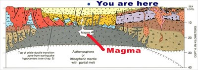 As the plates have moved away from each other, the
land in the middle has dropped down. Sediment from the surrounding
mountain rainges and the Colorado River have filled it in. Now
there are thousands of feet of sediment laying on top of the
spreading center.
As the plates have moved away from each other, the
land in the middle has dropped down. Sediment from the surrounding
mountain rainges and the Colorado River have filled it in. Now
there are thousands of feet of sediment laying on top of the
spreading center.
Image source: Irwin, date?
The crust of the earth is very thin at a spreading center so
magma from deep in the earth comes relatively close to the
earth’s surface. This magma heats surrounding rocks and
groundwater. The rocks and groundwater are still under a lot of
pressure from the rocks that are above them, so the water can
become superheated. At about 3000 feet below the ground, the
temperature is over 572 degrees F.
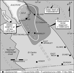 The figure to the right shows the approximate area
where temperatures exceed 464 degrees F within 1.8 miles of the
surface. (The author calls this area the Greater Salton Sea
Geothermal Cluster [GSSC]). This is the area where current
technology can be used extract the geothermal energy. Wells are
drilled down to tap this superheated water and bring it to the
surface. At the surface the geothermal plant uses this superheated
water to power its generators (that process is outside the scope of
this discussion).
The figure to the right shows the approximate area
where temperatures exceed 464 degrees F within 1.8 miles of the
surface. (The author calls this area the Greater Salton Sea
Geothermal Cluster [GSSC]). This is the area where current
technology can be used extract the geothermal energy. Wells are
drilled down to tap this superheated water and bring it to the
surface. At the surface the geothermal plant uses this superheated
water to power its generators (that process is outside the scope of
this discussion).
Image source: Jeffrey Hulen, 2005
In addition to creating the superheated water, the heat and
pressure are creating greenshist (a metamorphic rocks) from the
sedimentary Colorado River rocks that have filled the basin.
Logging requirements:
Send me a note with :
- The text "GCZ5XF Salton Sea Geothermal Field" on the first
line
- The number of people in your group.
- Send me a note with some other evidence you see to indicate
there is volcanic activity in the area.
- What you expect to happen to the surrounding area over geologic
time?
The following sources were used to generate this
cache:
- Anza CALENERGY Generation Webpage, Imperal
Valley (United States) Generation, Geothermal Fact Sheet,
http://www.calenergy.com/html/projects2d.asp
- Dr. Barry Weaver,
http://ve.ou.edu/weaver/plates/spread.htm
- Gary S. Fuis and Walter D. Mooney, Ch. 8
Lithospheric Structure and Tectonics from Seismic-Refraction and
Other Data in Robert E. Wallace, editor, The San Andreas Fault
System, California, U.S. Geological Survey
http://education.usgs.gov/california/pp1515/chapter8.html
- William P. Irwin, Ch. 3. Geolgoy and
Plate-Tectonic Development in Robert E. Wallace, editor, The San
Andreas Fault System, California, U.S. Geological Survey,
http://education.usgs.gov/california/pp1515/chapter3.html
- Jeffrey B. Hulen and Fred S. Pulka,
Newly-Discovered, Ancient Extrusive Rhyolite in the Salton Sea
Geothermal Field, Imperial Valley, California, Proceedings,
Twenty-Sixth Workshop on Geothermal Reservoir Engineering Stanford
University, Stanford, California, January 29-31, 2001,
SGP-TR-168
- USGS/Cascades Volcano Observatory, Vancouver,
Washington, Salton Buttes Lava Domes,
http://vulcan.wr.usgs.gov/Volcanoes/California/SaltonButtes/description_salton_buttes.html
- Jeffrey B. Hulen, 2005, Low-Angle Extensional
Tectonics, Flat Fracture Domains, and Gravity Slides in
Hydrothermal and EGS Resources of the WEstern U.S.
(DE-FG36-04GO14296) Dated April 7, 2005