Three Rivers Petroglyph Site is located 17 miles north of
Tularosa, NM, and 28 miles south of Carrizozo, NM on U.S. 54. Turn
east from U.S. 54 at Three Rivers onto County Road B30 and travel
five miles on paved road, following signs.
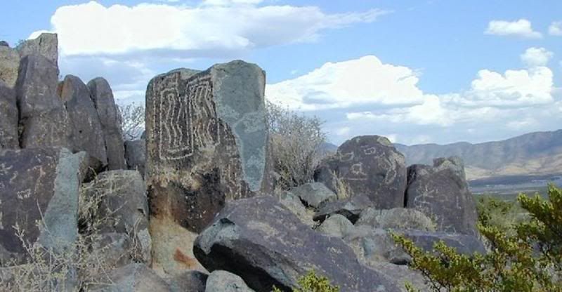
The Three Rivers Petroglyph Site is one of the few locations in
the Southwest set aside solely because of its rock art. It is also
one of the few sites giving visitors such direct access to
petroglyphs. The number and concentration of petroglyphs here make
it one of the largest and most interesting petroglyphs sites in the
Southwest.
More than 21,000 glyphs of birds, humans, animals, fish, insects
and plants, as well as numerous geometric and abstract designs are
scattered over 50 acres of New Mexico's northern Chihuahuan Desert.
The petroglyphs at Three Rivers, dating back to between about 900
and 1400 AD, were created by Jornada Mogollon people who used stone
tools to remove the dark patina on the exterior of the rock.

A small pueblo ruin is nearby and Sierra Blanca towers above to
the east. A detailed petroglyph guide is available at the Three
Rivers Petroglyph Site. A rugged half-mile trail begins at the
visitor shelter and links many of the most interesting petroglyphs.
Another short trail begins on the east side of the picnic area and
leads to the remains of a Mogollon village, whose inhabitants were
likely responsible for the petroglyphs. Occupied for about 400
years, the site was partially excavated in 1976. On the village
site, there are foundations of three types of prehistoric
buildings. Native Americans originally occupied the site about
10,000 years ago. The descendants of the early occupants were the
Jornada Mogollon Indians, who inhabited the region 900 to 1400
AD.
The Jornada Mogollon Indians carved a remarkable number of
petroglyphs into the desert varnish on the smooth, rounded
weathered surfaces on the basaltic rocks in this area between 900
and 1200 AD. Desert varnish is a thin layer of manganese oxide,
iron oxide, and clay that is deposited by bacteria living on the
surface of the rock. The Mogollon Indians took advantage of the
desert varnish and left behind their artwork. It may be translated
as messages, seasons, or territorial signs. Desert varnish forms
only on physically stable rock surfaces that are no longer subject
to frequent precipitation, fracturing or sandblasting. The varnish
is primarily composed of particles of clay along with iron and
manganese oxides. There is also a host of trace elements and almost
always some organic matter. The color of the varnish varies from
shades of brown to black. 
New Mexico is one of the most geologically active areas of the
forty-eight contiguous states. On the surface volcanoes are resting
while rivers carve the earth, mountain ranges are thrust skyward,
and howling winds erode and deposit sand and soil. Yet hidden
beneath the surface is the culprit responsible for much of New
Mexico’s beauty, the Rio Grande Rift. It works slowly
spreading the continental crust apart while leaving evidence of its
powerful presence behind. Its effects are standing tall on the
Three Rivers Petroglyph Site.
Old volcanoes whose ancient flows gave birth to an extensive
mesa and a jagged, boulder-strewn escarpment. Working
together—the Rio Grande Rift, volcanoes, rivers,
wind—along with time, these earth forming forces continue to
mold New Mexico’s landscape. The Ro Grande Rift runs
vertically down the length of New Mexico. The rift formed when the
crust of the Colorado Plateau to the west pulled away from the
crust of the Great Plains to the east. As the divergence continued,
a giant crack developed where the Colorado Plateau and Great Plains
meet. The crust in between was stretched and thinned like soft
baking dough. Large blocks of the crust dropped down into the
crack. A trough was created by this cracking and down-dropping. The
trough is forty miles wide in some areas. Three Rivers Petroglyph
Site is located in the rift. 
The area surrounding the rift was unstable and subject to many
earthquakes that formed deep cracks, called fissures. Geologists
estimate that 130,000 years ago magma rose along a five-mile long
fissure and reached the earth’s surface. Being a non-violent
fissure eruption, lava flowed eastward in a sheet-like fashion and
covered the Santa Fe mation, an accumulation of sand and gravel up
to 25,000 feet thick. The lava cooled and hardened, transforming
into basalt rock.
Basalt is an extrusive igneous rock that is very dark in color.
It is the most common type of rock in the Earth's crust and it
makes up most of the ocean floor. It is made of many dark colored
minerals such as pyroxene and olivine. Basalt also contains some
light colored minerals such as feldspar and quartz, but the amounts
are small. Typically, you can't see most of the mineral crystals
without using a microscope because quick cooling prevents large
crystals from forming. Basalt forms when lava reaches the Earth's
surface at a volcano or mid ocean ridge. The lava is between 1100
to 1250° C when it gets to the surface. It cools quickly,
within a few days or a couple weeks, forming solid rock. Very thick
lava flows may take many years to become completely solid. 
American Indians and Spanish settlers carved their images on
these basalt boulders. The nature of the rock itself is what allows
the petroglyphs to be visible. The basalt is high in iron,
manganese and calcium. The combination of these minerals makes the
basalt a light gray color. After long exposure to oxygen and water
the iron and manganese oxidize or rust. A dark shiny coating, or
patina, forms on the surface of the basalt boulders. The patina is
called desert varnish. When looking at the dark basalt boulders,
you are actually looking at desert varnish.
American Indians discovered permanent marks could be made by
using another rock to chip off the desert varnish. Many American
Indians are able to claim cultural relationships to past
inhabitants of this area because they recognize the images as
having deep cultural and spiritual significance.
Please respect the importance of petroglyphs to American Indians
and to the descendants of original Spanish settlers.
The collection of artifacts from this site is prohibited and
against the law. The punishment is could be jail time, a fine or
both. If you do see something interesting do not touch it! Tell the
park supervisor and show him what you found. It will be recorded
and marked off if needed.
Stay on the designated trail! Any photos showing anyone off
of the trails or standing on the rocks will have the log deleted
immediatly.
Two dollars per vehicle for day use and camping.Open year-round.
From April to October, the entrance gate is open from 8:00 a.m.
until 7:00 p.m. From October until April, it’s open from 8:00
a.m. until 5:00 p.m.
To get credit for this EC, post a photo of you next to any of
the petroglyphs from the three rivers site and please answer the
following questions.
1. What is the dark layer on the rocks called?
2. How many diffrent petroglyphs are at the site?
3. What is the type of rock the petroglyphs on?
4. There are glass like pieces of rock laying on the ground
all around the EC site. Briefly describe what you think it is. Its
native to the area.

| Cav Scout has earned GSA's highest
level |
 |
Logs with no photo of the actual cacher logging the find or
failure to answer questions will result in a log deletion.
Exceptions will be considered if you contact me first (I realize
sometimes we forget our cameras or the batteries die). Logs with no
photos will be deleted without notice.
I have used sources available to me by using google search to
get information for this earth cache. I am by no means a geologist.
I use books, internet, and asking questions about geology just like
99.9 percent of the geocachers who create these great Earth Caches.
I enjoy Earth Caches and want people to get out and see what I see
everytime I go and explore this great place we live in.