To get to Cougar Canyon, you must first drive up Coyote
Canyon, making a couple of stream crossings and then traversing the infamous
bypass road. You will definitely need 4WD, good ground clearance and some
off-road experience to make the trip to the trailhead. You will need to be
in 4WD Low on the bypass road. You could hike to the trailhead, but it would be
a long haul. Make sure you check out the
Thank God I Made It cache when you get to the top of the bypass road.
Here are some waypoints for the drive to
the trailhead (Right
click and save here for .loc file):
01: N33 15.399 W116 21.959
From Town, Take
Di Giorgio Rd North
02: N33 19.517 W116 22.056 Start of Dirt Road
03: N33 21.474 W116 23.871 1st Crossing
04: N33 21.946 W116 24.965 2nd Crossing
05: N33 22.285 W116 25.411 3rd Crossing
06: N33 22.236 W116 25.697 Start of Bypass Road (Put it
in Low)
07: N33 22.439 W116 26.954 Turn Left (Sign says Sheep
Canyon)
08: N33 21.892 W116 28.604 Trailhead/Parking
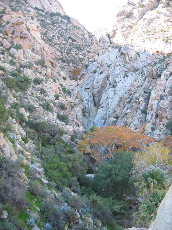
From the trailhead, hike .7 miles up Indian
Canyon to get to the start of the Cougar Canyon Trail. The trail
starts out fairly flat and well defined, but gets harder to navigate as
you continue up the canyon. After the flat section, you will cross
the stream and stay
along the north side of the canyon for a good part of the hike. You
will eventually reach a point where you can go no further on the north side
and you will have to cross the stream again. From here you will have
to navigate back and forth across the stream a few times as you continue.
Here are some waypoints for the hike up the canyon:
09:
N33 21.294 W116 28.635 Start of Cougar Canyon Trail
10: N33 21.293 W116 28.968 Indian Cave w/Pictograph (Sensitive Area)
11: N33 21.270 W116 29.000 First waterfall
12: N33 21.214 W116 29.065 Cross stream here and
continue back and forth across stream as necessary.
13: N33 21.209 W116 29.184 Waterfall/Grotto Area.
|
 |
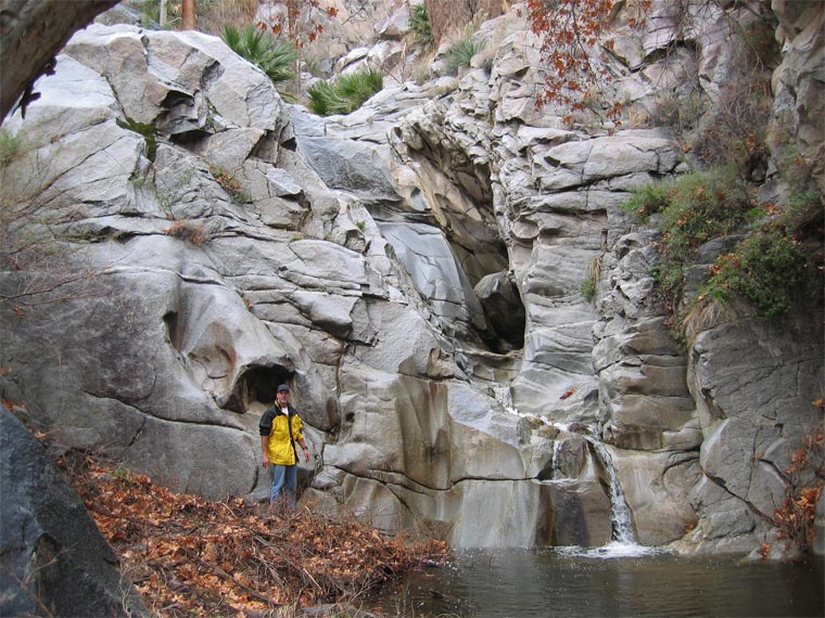
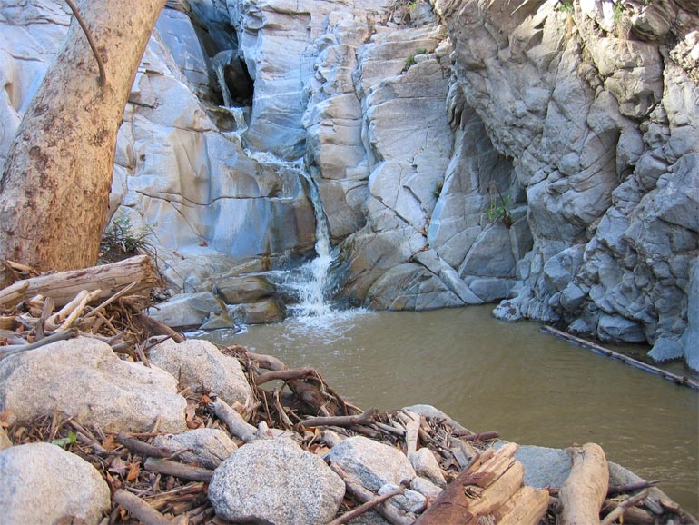
You will reach a beautiful waterfall/grotto area at the
last set of coordinates above. This was the location of the original Dead
Eye @ Cougar Canyon cache which washed away in the severe flash flooding in the fall
of 2004. This flooding changed the look of the entire streambed significantly.
 |
 |
|
Grotto Area Before Flash Flood |
Grotto Area After Flash Flood (Notice
Extra Lower Rock Face Exposed) |
From the waterfall/grotto area, you will need to hike
up the canyon wall
on the south side, starting adjacent to the rock face of the waterfall.
After hiking up the canyon wall, you will be able to continue up the canyon
along this south side of the canyon. You will find the cache along the
south canyon wall. There are great views up and down canyon from the cache
location. Make sure you hike down to the second waterfall/grotto area that you can see just up the canyon from the cache site. This is the area
that Jerry Schad described as "the most beautiful spot of all, a clear deep pool
surrounded by sheer, polished granite walls, fed by a 20-foot waterfall."
We hope you enjoy this hike as much as we did,
Rocket Man, Fkrexcal & Trailgators