The Jebel al-Akhdar mountain range in Oman has a unique origin.
They are Ophiolites, solidified lava flows originating from the
mid-oceanic ridge, where sea-floor spreading was taking place, in
the ancient Tethys ocean once separating Europe from Africa. As
continents drift over the surface of the earth, propelled by
deep-seated magma flows in the Earth's upper mantle, new crust is
continuously being formed by up-welling lava along the mid-ocean
ridges.
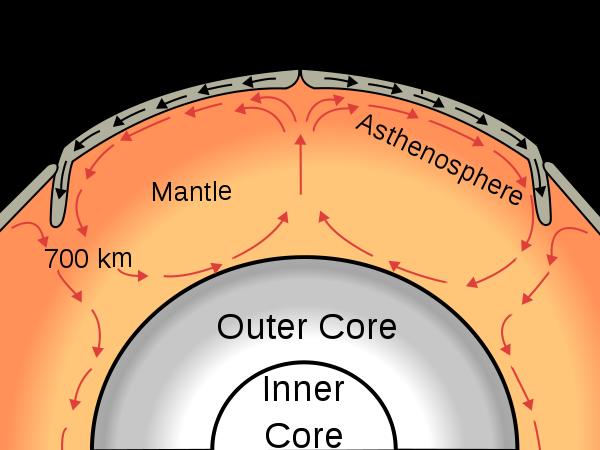
As soon as the lava comes into contact with cold sea water it
solidifies in characteristic "pillow lava" mounds. The ongoing
spreading then transports this igneous (= volcanic) rock on a 2-way
conveyor belt away to either side of the central ridge. As long as
it remains in the deep sea it will be exposed to a continuous rain
of dead microscopic sea creatures containing a calcium carapace.
This, over the course of millions of years, creates the limestone
layers that typically overlay the ophiolite rock formation. Once
they have arrived at the other side of the "conveyor belt", the
subduction zone where one side of a continental plate pushes
against that of another plate , one side will be sub-ducted and get
re-absorbed into the core magma flows, while the other side will be
uplifted in a process of mountain building often accompanied by
volcanic activity. The latter process of mountain building was the
fate of the Oman ophiolites as they completed their journey from
the depths of an ancient ocean to the heights of the current
imposing mountain range.
Along the mid-ocean ridges another process is taking place.
Seawater enters the cracks and fissures of the ridge and leaches
out mineral salts while being heated up to very high temperatures.
As this hot water rises again and gets into contact with colder
ocean water, the mineral salts precipitate and form mineral-rich
deposits among the solidified lava. A particular form of such an
upwelling, a black smoker, can be seen in the following video clip).This
"hydro-thermal circulation" thus concentrates minerals, which are
present in trace amounts in all the lava, into discrete pods where
the hot water manages to break through to the ocean floor. The
Lusail copper mine is - or rather was, as it is now exhausted - one
of these "pods" of mineral rich ophiolite. While copper was the
predominant metal, other metals such as nickel and even gold were
found mixed in in trace amounts.
As you arrive at the mine location you will notice the deep pit
which has been left behind by removing all the rock containing
economically retrievable copper salts. Notice the black featureless
walls of the ophiolite rock lining the pit and forming the ridges
and hills all around the mine. On top of the ophiolite you will
often see the tan-coloured limestone, showing clear layering, that
has been deposited after the underlying rock had been transported
away from the mid-ocean ridge. Look around you and marvel at the
multi-coloured rocks lying on the ground: reds, pinks, purples and
yellows each made of different mineral salts, containing a variety
of metals. The most common are the turqoise / green coated rocks
containing the copper ore. Look carefully and you may find examples
of "fools gold", scientifically known as copper pyrite, a mixture
of copper, iron and sulphides.
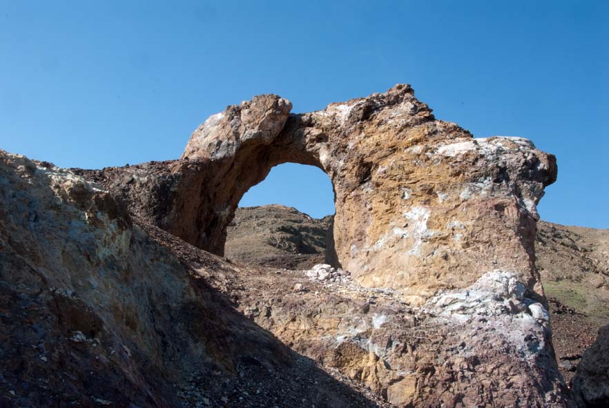
A very famous landmark right next to the open-cast mine is a
rock arch - the actual Ground Zero of this Earth cache. It's age
and origin is unknown but it may well be the remains of a mine
tunnel entrance left over when the ceiling of the mineshaft behind
it collapsed. Mining took place since Mesopotamian times, 4000
years ago and numerous archaeological sites have been identified in
the area (see Arja's Ziggurat cache:
GC236AJ). According to Sumerian texts found on clay tablets
from the 3rd century BC, this area called 'Magan' harboured 32
mining settlements built along the wadis and foothills of the
mountains. Evidence of ancient mining shafts have been found at the
Lusail mine, some going as deep as 88 m underground with horizontal
shafts of 20 to 30 m long being supported by beams of acacia wood
and palm tree trunks.
To reach the cache turn off the main Sohar - Buraimi highway at
the coordinates provided below and follow an asphalt road,
currently in poor repair, which crosses Wadi Jizzi and continues
directly to the mine site. The mine has been abandoned some 20
years ago and an earthen barrier had been erected over the road, to
warn travellers of the dangers behind. The barrier has now been
washed away, but visitors should be aware of the dangers of the
mine site. The edges of the 100 m deep pit are crumbling away or
even partly caved in so extreme care should be taken. Children
should be supervised closely by adults. There are a number of deep
mine shafts which are cordoned off with wire fencing but again over
the years their effectiveness has diminished. Visitors coming from
the UAE are recommended to use the "Shiklah" borderpost, at the
coordinates below. Shiklah is signposted from the roundabout in
front of the Intercontinental hotel Al Ain .
As this is an Earth cache no physical box is to be found. To log
a find for this cache please send your answers to the following
three questions by clicking on my geocaching name above and
choosing the "send Message" option:
1. why did they abandon the mine 20 years ago and why did they
not continue digging up the black ophiolite rock?
2. how thick do you reckon is the tan limestone layer covering
the black ophiolite at the mine site?
3. At the bottom of the open-cast mine a lake has formed. What
colour is the water?
Finally when logging your find on www.geocaching.com please
include a photo of your GPSr with the rock arch at GZ in the
background. You can log your find immediately, but any logs that
are not supported after one week by answers to the above three
questions and a photo of your GPSr will be deleted by me!
Have fun!