

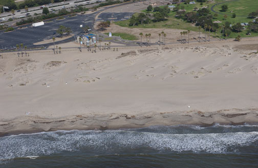
Coastal Dune N 34 16.173 W 119 16.770
Compared to other dune fields in California, the dunes at San
Buena Ventura State Beach are small. Larger dune fields can be
found near Monterey Bay, Nipomo, Humbolt Bay and San Diego Bay.
Coastal Dunes develop where on-shore winds blow sand in from the
beach. The sand then accumulates around something that slows the
wind, such as drift wood or plants. Over time, a mound develops
which also slows the wind creating a larger mound.
An equilibrium develops between sand being deposited on the
windward side (the ocean side) and being blown off the top or the
back (landward side) until the dune is stabilized by dune
vegetation. Typically the dunes will form into 2 or 3 sets of
parallel ridges that are perpendicular to the prevailing wind.
Usually, the oldest dunes are furthest from the beach and the
youngest dunes are closest to the beach. The oldest dunes have the
most vegetation and are the least susceptible to wind erosion.
Based on other coastal dunes in California, it is estimated that
the oldest dunes may be as much as 18,000 years old. As you walk
toward the beach notice how the amount of vegetation on the dunes
changes and see if you can see the sets of parallel ridges. (Don't
worry if you can't really see them, they are difficult to see from
ground level).
Also notice the difference between the fenced corridor you're
walking in compared to the protected dunes. The walking corridors
are flat and unvegetated. Dunes and dune vegetation is easily
damaged resulting in the relatively quick erosion of the dunes.
Natural dunes play a key role in reducing coastal erosion.
During heavy winter storms, the sand from the youngest dunes are
eroded to form off-shore bars that dissipate the energy of the
waves. The dunes are then rebuilt the next summer. This process is
the focus of the next waypoint of the cache.
This section was developed using
California Coastal Commission's California Coastal Resource Guide
http://ceres.ca.gov/ceres/calweb/coastal/dunes.html
Seasonal Sand Movement N 34 16.170 W 119 16.876
Sand on the beach is constantly being moved around. As you can see,
each wave that comes in pushes around the sand on the beach,
turning the ocean water at the shore brown. The difference in
energy between summer and winter waves drastically changes the look
of the beach.
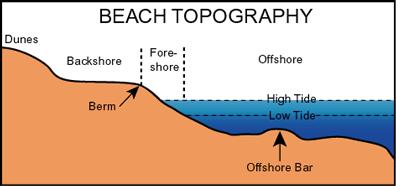 To examine this seasonal change, it is good
to have names for the different parts of the beach. In this
case, we'll look at three parts, the backshore, the foreshore,
and offshore.
To examine this seasonal change, it is good
to have names for the different parts of the beach. In this
case, we'll look at three parts, the backshore, the foreshore,
and offshore.
The backshore begins at the vegetated sand dunes to the high
tide level and is comprised of the berm and berm crest. The berm is
the relatively flat sandy area where everyone loves to put their
beach towels. At the berm crest, beach slopes more steeply to the
high tide level. The width of the berm changes seasonally. During
the summer it is wider than during the winter. This change in width
results in the moving shoreward or seaward of the next two
zones.
The foreshore begins at the high tide line and stretches to the
low tide line. This section of beach in usually slopes downward at
a uniform level. Because of the tides, this section of beach is
periodically below sea level or above sea level.
Beyond the foreshore is the offshore beginning begins at the low
tide line and extending off shore. This section of the beach is
always below sea level but constantly affected by the waves. The
offshore profile changes seasonally. During the summer, it is a
relatively uniform slope down. During the winter, a trough (low
point) forms with mounds of sand (bars) eroded from the berm
shoreward and seaward of the trough.
The seasonal changes noted above are caused by the different
energy levels of summer and winter waves. Winter storms generate
waves with more energy than summer waves.
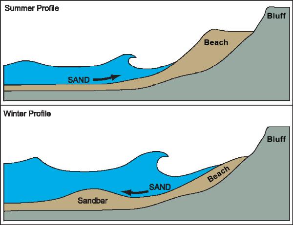 The winter waves erode sand off the beach
and store it in offshore bars. The winter waves have enough
energy to not only pick up sand as they come into shore but
also transport it off of the foreshore. The largest storm
generated waves also erode the face of the berm crest,
reducing the width of the berm. The sand is then deposited in
sandbars off-shore.
The winter waves erode sand off the beach
and store it in offshore bars. The winter waves have enough
energy to not only pick up sand as they come into shore but
also transport it off of the foreshore. The largest storm
generated waves also erode the face of the berm crest,
reducing the width of the berm. The sand is then deposited in
sandbars off-shore.
During summer, the waves are milder. These waves have enough
energy to transport sand as they come into shore. As the water
flows back to the ocean, there is not enough energy to transport as
much sand as the wave brought onto the forshore back off shore,
resulting in a net gain of sand. This results in the gradual build
up of the berm crest and the berm widens for the summer.
Post a picture from this waypoint facing the next waypoint. As
we get a series of pictures over the seasons we should be able to
see the changes to the beach. If you don't have a camera, send me a
note of the number of the lifeguard tower.
This section was developed using
-
http://coastalchange.ucsd.edu/st3_basics/beaches.html
-
http://www.ocean.uni-bremen.de/EInfo/materialien/elemOc/top12-17/topic14.html
Lonshore Transport N 34 16.244 W 119 16.983
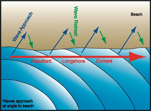 When waves approach the shore at an angle
they generate a current parallel to the shore called the
longshore current. At various points along the shore, the
water in the longshore current returns back to the ocean in
rip currents. Rip currents are fast moving currents that move
directly out to the ocean. The result is the transport of sand
down the coast. In a natural system, the sand that is moved
down the coast by the longshore current is replaced by
sediment brought down to the ocean by rivers further up the
coast(See http://coastalchange.ucsd.edu/st3_basics/waves.html
for a good graphic on the process).
When waves approach the shore at an angle
they generate a current parallel to the shore called the
longshore current. At various points along the shore, the
water in the longshore current returns back to the ocean in
rip currents. Rip currents are fast moving currents that move
directly out to the ocean. The result is the transport of sand
down the coast. In a natural system, the sand that is moved
down the coast by the longshore current is replaced by
sediment brought down to the ocean by rivers further up the
coast(See http://coastalchange.ucsd.edu/st3_basics/waves.html
for a good graphic on the process).
On this beach, waves usually come from the northwest, so sand
would normally be transported from the northwest to the southeast.
However dams on the rivers inland from this beach have reduced the
amount of sand reaching this beach (See related Matilija Dam Removal). As a
result, the longshore current began transporting more sand down
the coast than was being added by the river causing the beach to
be eroded.
In an attempt to protect this beach groins were installed.
Groins are the artificial rock walls that extend out into the ocean
perpendicular to the beach. Groins are designed to stop the
longshore transport of sand. To be effective, a series of groins
must be constructed along the beach.
As you can see, they are effective, if unsightly. Sand builds up
on the northwest side of each groin and is eroded from the
southeast side. This keeps the sand on this section of beach.
However, further down the coast where the groins stop, the coast
may be sand deprived because it is not receiving the sand that
would have been transported down the coast from this beach.
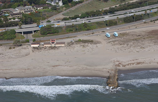
October 2004
source: http://www.californiacoastline.org/
This section was developed using
- KIKI PATSCH and GARY GRIGGS, OCTOBER 2006,
LITTORAL CELLS, SAND BUDGETS, AND BEACHES: UNDERSTANDING CALIFORNIA
S SHORELINE; INSTITUTE OF MARINE SCIENCES UNIVERSITY OF CALIFORNIA,
SANTA CRUZ CALIFORNIA DEPARTMENT OF BOATING AND WATERWAYS
CALIFORNIA COASTAL SEDIMENT MANAGEMENT WORKGROUP
-
http://coastalchange.ucsd.edu/st3_basics/waves.html
California Coastal Commission's California Coastal Resource Guide
http://ceres.ca.gov/ceres/calweb/coastal/beaches.html
- Sherman, Douglas J., Karmon M. Barron, and Jean
T. Ellis, Retention of Beach Sands by Dams and Debris Basisns in
Southern California, Journal of Coastal Research, Spcial Issue 36,
2002
- Office of Naval Research; Habitats: Beaches -
Characteristics;
http://www.onr.navy.mil/focus/ocean/habitats/beaches1.htm
Logging requirements:
Send me a note with :
- The text "GCPRGE Beach Sand Movement - San Buenaventura" on the
first line
- The number of people in your group.
- Measure the distance from where the sand piles up on the rocks
on the upcurrent side and where it has been eroded back to on the
down current side. Post that distance in your log. It will change
based on the season, so you can't just read someone else's log. A
pair of coordinates will do as well.
- Send me a note saying explaining why the paths from the parking
lot to the beach are lower than the sand dunes.
Please begin your e-mail with the name of the earthcache and be
sure your log indicates how many people were in your
group.