
Located at Fort Casey State Park, the park is the site of the Admiralty Head Lighthouse. A coast artillery post features four historic guns on display. The park offers spectacular views of Admiralty Inlet and the Strait of Juan de Fuca. ___________________________________________________________________________
HISTORICAL FEATURES
Even today a great deal of maritime freight traffic passes through Admiralty Inlet to the major shipping ports at Seattle and Tacoma, and of United States Navy vessels to the Naval facilities in Puget Sound. All sea vessels must pass through Admiralty Inlet to enter or leave Puget Sound, except those small enough to use Deception Pass.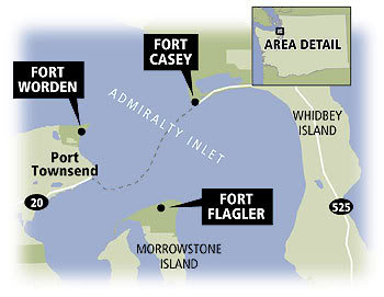 This fact led to the selection of Port Townsend as the official port of entry for the Puget Sound region during the early days of commerce in the area. Admiralty Inlet was also considered so strategic to the defense of Puget Sound at the turn of the century that three forts were built at the entrance with huge guns creating a "Triangle of Fire" that could theoretically thwart any invasion attempt by sea. Fort Worden anchored the northwest side of the triangle, Fort Flagler anchored the southwest, while Camp Casey sits here almost directly across Admiralty Inlet from Fort Worden.
Camp Casey was built in the early 1900s. It and the other two forts with long-range guns were intended to protect the entrance to Puget Sound against any invading ships. But the forts became obsolete soon after they were built as armaments on ships were rapidly improved, and aerial warfare later sealed their doom. The military's loss, however, was the public's gain. All three forts have been turned into state parks.
GEOLOGIC FEATURES
Puget Sound is a semi-enclosed, glacial fjord where saltwater from the ocean is mixed with fresh water draining from the surrounding watershed. Made up of a series of underwater valleys and ridges called basins and sills, Puget Sound is deep, with an average depth of 450 feet. It extends from the Strait of Juan de Fuca to Olympia, Washington. A relatively shallow sill at Admiralty Inlet separates the waters of the Strait of Juan de Fuca from the waters of Puget Sound proper. Glaciers have repeatedly occupied the Puget Lowland. At least three and possibly as many as six episodes of glaciation have rearranged the landscape and left evidence of their passage in the rocks and sedimentary record.  In geography a sound or seaway is a large sea or ocean inlet larger than a bay and deeper than a bight. A sound is often formed by the sea flooding a river valley. This produces a long inlet where the sloping valley hillsides descend to sea-level and continue beneath the water to form a sloping sea floor. Sometimes a sound is produced by a glacier carving out a valley on the coast then receding, or the sea invading a glacier valley. The glacier produces a sound that often has steep, near vertical, sides that extend deep under water. The sea floor is often flat and deeper at the landward end than the seaward end, due to glacial moraine deposits.
Admiralty Inlet, located here, is generally considered to be the northern part of Puget Sound's Main Basin. Though only 3.7 miles wide at the narrowest point, it is through this passage that nearly all the seawater flows into and from Puget Sound during daily tidal variations. (Only 2% flows through Deception Pass.) The configuration of basins, sills, and interconnections cause the tidal range to increase within Puget Sound. The difference in height between the Higher High Water and the Lower Low Water averages about 8.3 feet at Port Townsend on Admiralty Inlet, but increases to about 14.4 feet at Olympia, the southern end of Puget Sound.
Along America's Atlantic Coast, two high and low tides occur daily, with relatively little difference between successive high and low waters. Such tides are called semi-diurnal. On the north shore of the Gulf of Mexico, the tide is diurnal, meaning that it moves in and out again but once a day. Here in the Pacific Northwest, we get mixed tides, two highs and two lows a day, characterized by significant disparity between successive tides which is called a semidiurnal mixed tide.

To qualify as a "find", email, (do not post online), the answers to the following questions and perform the following tasks. Failure to do that in a timely manner will result in a log deletion.
Visit the interpretive sign at the posted coordinates and answer the following questions:
1) What is the 5th rule on the kiosk board under "Fort Rules"?/span>
2) Visit Waypoint 2, or anywhere else in the park where you may have a good view of Admiralty Inlet. Since Admiralty Inlet is still an important waterway for seagoing vessels, please observe the water traffic for a few minutes and tell us what you saw on the day of your visit. You may post this in your log if you want to!
3) Estimate the width of the Puget Sound at your observation point.
4) At the time of your visit, does it appear to be high tide, low tide, or somewhere in between? After returning home check your answer, here (Admiralty Head, Whidbey Island). Now, also check for Tacoma, (Olympia, Budd Inlet). If you remember, there is a great disparity in tidal fluctuations from the seaward end to the landward end of the Puget Sound. On the day of your visit what was the difference between the two locations for the higher-high tide?
5) Which type of Sound formation do you think created the Puget Sound and why did you choose that type?
UPLOAD a photo with the lighthouse or the bunkers in the background with yourself and attach it to your found log.
We hope you have learned a thing or two about the Puget Sound and thanks for visiting Fort Casey State Park!

|
- The geocache may be placed on Washington State Parks and Recreation Commission managed property only by written permission from the Washington State Parks and Recreation Commission.
- The following items shall not be placed in the geocache: Food items; illegal substances; medications; personal hygiene products, pornographic materials; inappropriate, offensive, or hazardous materials or weapons of any type. Log books are required for each cache and are to be provided by the owner of the cache.
- It is the visitor’s responsibility to orient themselves with policies and rules pertaining to State Parks areas.
- Report any incident, problem, or violation to State Parks staff.
|
 |
Warning: Earthcaches come with a unique set of rules and activities that must be met
before successfully logging. Failure to comply will result in a log deletion.
|
|