|
Eagle River Bridge EarthCache
Short Description:
This EarthCache will take you to a pedestrian bridge overlooking the Eagle River in the Keweenaw Peninsula not far from Great Sand Bay. The site has several geological features of interest: a waterfall, a geological contact, and several potholes.
Coordinates:
Latitude: 47° 24.746'N Longitude: 88° 17.807'W
Key Earth Science Vocabulary Words:
Potholes: A circular hole in the bed of a river produced by abrasion.
Geological Contact: The surface along which one rock touches another. They may be either Depositional, Intrusive, of Fault contacts.
Waterfall: A steep fall or flow of water in a watercourse from a height, as over a precipice; cascade.
Glacier: A thick mass of ice that forms on land from an accumulation of snow significant enough to persist through the summer and grow year by year.
Sandstone: A sedimentary rock composed of sand-sized particles (1/16 to 2 millimeters in diameter).
Basalt: A dark-colored fine-grained extrusive igneous rock. It is formed when lava cools quickly on the surface.
Conglomerate: A sedimentary rock that contains large (greater than two millimeters in diameter) rounded particles. The space between the pebbles is generally filled with smaller particles and/or a chemical cement that binds the rock together.
Escarpment: A long cliff or steep slope separating two comparatively level or more gently sloping surfaces and resulting from erosion or faulting.
Content Explanation:
This site at Eagle River is full of interesting geological features. The waterfall flows down a rather wide escarpment composed of a hard dark colored basalt rock. Basalt is formed when lava cools quickly on the surface. This area was once the site of over 400 lava flows during the Precambrian over 1 billion years ago! (W. Rose, personal communication, July 11, 2011). Covering the basalt is a layer of red sandstone. The sandstones red color tells us that oxygen was present in the atmosphere when the sandstone was made. (W. Rose, personal communication, July 11, 2011) .The sandstone is more easily eroded than the basalt and therefore much of it has been eroded by the action of the river.
If you look closely at the bottom of the escarpment you can see where the basalt and the sandstone layers meet. This area is called a geological contact. Geological contacts are areas where rocks of different formation and age come in contact with each other. On the other side of the bridge you can see another area of geological contact between the basalt rock layer and a conglomerate rock layer. The rock layers are tilted towards the lake. This is a result of the Mid-continent rift that happened about 1.1 to 1.0 billion years ago and caused the lava flows that formed the basalt rock. (W. Rose, personal communication, July 11, 2011)
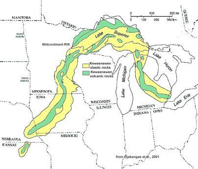
Figure 1: Midcontinental rift system
Perhaps the most interesting formation at this site are the potholes found all over the escarpment. The formation of these cylindrical holes in the basalt is still under debate by members of the geological community. Two major hypotheses about the pothole formations have been proposed: 1. Bubble Cavitation and 2. Stone Scouring. (W. Rose, personal communication, July 11, 2011). The bubble hypothesis proposes that fast moving water contains bubbles in a vortex that smashes into the rock forming the pothole. The stone scouring hypothesis proposes that the water used hard rocks to scour the potholes in the parent material much like a chemist’s mortar and pestle. Regardless of the exact method of formation it appears that fast flowing water (most likely from glacial melt water) played a critical role.
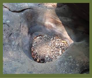
Figure 2: Pothole in Coquille River Falls, Oregon
Logging Questions:
Q1: Which rock layer is older the conglomerate or basalt? How can you tell?
Q2: Describe the size, shape and number of potholes that you observe. Based on your observations, how do you think these potholes were formed? provide reasoning for your claim.
Access Information:
This site is publicly accessible. Parking is adjacent to the site in the Houghton Township Center Parking Lot. |