THIS EC REQUIRES A STEEP WALK TO THE LIGHTHOUSE
ALTERNATE LOCATION TO COMPLETE THIS EARTHCACHE
The Lewis & Clark Interpretive Center
244 Robert Gray Drive Illwaco, WA
Ilwaco, WA 98624-8624
Contact (360) 642-3029
TO CLAIM THIS EARTHCACHE:
ÜPart One: Field Work
ÜPart Two: Email (please do not post) the answers to the questions listed below. The answers can be found by reading the text on this Earthcache's page.
FIELD WORK
From where you are standing:
- What are the tidal conditions at the time of your visit?
- What is the wave activity today? Give an approximate height of the tallest wave.
- Do you think this would be a good time to enter the river and cross the bar, and why?
- What are the fog conditions today?
- From your location at the lighthouse or the Lewis and Clark Interpretive Center, please take a photo of yourself holding your GPS with the Columbia Bar in the background.
QUESTIONS
- What gives the river its tremendous potential for the generation of electricity?
- Which river is the largest hydroelectric power producing river in North America?
- How many dams can be found on the Columbia River and its tributary rivers?
- The river's current often dissipates into the Pacific Ocean as what?
- Why does this wreak havoc on vessels of all sizes?
- Since 1792, approximately how many ships have sunk in and around the Columbia Bar?
- At the Columbia Bar, what can cause even the biggest ocean liners to sink?
- Who do these ocean liners rely on to guide them safely through the bar?
- Should you want this job, approximately how much money would you make per year?
|
|
|
|
The Columbia River (known as Wimahl or Big River to the Chinook-speaking natives who live on its lowermost reaches) is the largest river in the Pacific Northwest region of North America. It stretches from the Canadian province of British Columbia through Washington, forming much of the border between Washington and Oregon before emptying into the Pacific Ocean. The river is 1,243 miles (2,000 km) long, and its drainage basin is 258,000 square miles (670,000 km2).
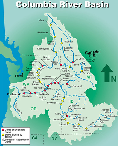
Measured by the volume of its flow, the Columbia is the largest river flowing into the Pacific from North America and is the fourth-largest river in the United States. 1The river's heavy flow, and its large elevation drop over a relatively short distance, give it tremendous potential for the generation of electricity. 2It is the largest hydroelectric power producing river in North America with 3fourteen hydroelectric dams in the United States and Canada, and many more on various tributaries.
The taming of the river for human use, and the industrial waste that resulted in some cases, have come into conflict with ecological conservation numerous times since Americans and Europeans began to settle the area in the 18th century. This "harnessing", as it was commonly described in the popular culture of the early 20th century, included dredging for navigation by larger ships, nuclear power generation and nuclear weapons research and production, and the construction of dams for power generation, irrigation, navigation, and flood control.
The Columbia River drains a 259,000-square-mile basin that includes territory in seven states (Oregon, Washington, Idaho, Montana, Nevada, Wyoming, and Utah) and one Canadian province - roughly the size of the country of France.
The Columbia River Basin is the most hydroelectrically developed river system in the world. More than 400 dams -- 11 run-of-the-river dams on the mainstem -- and hundreds of major and modest structures on tributaries block river flows and tap a large portion of the Columbia's generating capacity: more than 21 million kilowatts.
The average small home runs on 200 kilowatts of power or less a month.
|
|
.The Columbia Bar
|
|
The north and south jetties are rock structures that stretch thousands of feet seaward. They restrict and speed up the Columbia’s flow, helping it sweep silt out of shipping lanes. |
The Columbia Bar is part of a set of significant marine coastal hazards along the Pacific Northwest coast, including Cape Flattery at the northwest tip of the Olympic Peninsula and Cape Scott, located at the northern tip of Vancouver Island. Historically, this region's nickname to mariners was the Graveyard of the Pacific, and the area is studded with thousands of shipwrecks. The "Graveyard" also includes the rocky, rugged shoreline of the west coast of Vancouver Island, the shores of the Olympic Peninsula, and the Strait of Juan de Fuca.
The Columbia Bar is a bar at the mouth of the Columbia River between the U.S. states of Oregon and Washington. The river's current often 4dissipates into the Pacific Ocean as large, standing waves, partially caused by the deposition of sediment as the river slows. 5These standing waves are usually mixed with ocean waves and wreak havoc with vessels of all sizes. The Columbia current varies from 4 to 7 knots (4.6 to 8 miles per hour) westward, thereby entering the predominantly westerly winds and ocean swells, which create significant surface conditions. Unlike other major rivers, the current is focused "like a firehose" without the benefit of a river delta. Conditions can change from calm and serene to life-threatening, breaking waves in as little as five minutes due to changes in the direction of wind and ocean swell. Since 1792, approximately 62,000 large ships have sunk in and around the Columbia Bar.
What is a river bar?
A harbor or river bar is a sedimentary deposit formed at a harbor entrance or river mouth by the deposition of sediment or the action of waves on the seafloor or adjacent beaches. A bar can form a dangerous obstacle to shipping, preventing access to the river or harbor in unfavorable weather conditions or at some states of the tide. Where beaches are suitably mobile, or the river’s suspended and/or bed loads are large enough, wave action can build up a bar to completely block a river mouth, damming the river, preventing access for boats or shipping, and causing flooding in the lower reaches of the river. This situation will persist until the bar is eroded by the sea, or the dammed river develops sufficient head to break through the bar.
How do you prevent a river bar from forming?
In the early 1900s, jetties were built at the entrances to the Columbia River. These jetties were designed to scour out sandbars and keep navigation channels open. Beaches, inlet entrances, and the nearby seafloor are still changing as a result of jetty construction over a century ago.
Ok, so what's the big deal?
The Columbia River opening to the Pacific Ocean is 4 miles wide. This is where the ocean water meets the powerful river water that has been collecting for over 1200 miles. At this point, several things happen. 7Much silt is deposited from the river and the two currents rushing together make a whitewater display that can even the biggest ocean liners sink. Couple this with stormy ocean conditions with 70 mile per hour winds and it is very, very dangerous. The waves can be 40 to 70 feet high and can crash over the ships. These ships can't simply plot a course with their GPS and follow it. Instead, 8they must be lead by Bar Pilots, who carefully navigate the ships through the bar and its ever-changing location. A bar that changes location coupled with the tide flowing in and going out makes for a very complicated situation.
Tides are the vertical rise and fall of the water and tidal current is the horizontal flow of the water. There are roughly two tides each day in the Pacific Northwest. Tidal movement toward the shore or upstream the flood current. Movement away from shore or downstream is the ebb current. The period between known as slack water.
It is extremely dangerous to get caught on the bar during a strong ebb current. Tidal currents may gain tremendous velocity, particularly when the ebb current is augmented by river runoff. Even on relatively calm days, a fast-moving ebb can create bar conditions that are too rough for small craft.
Surf's up!
Heavy surf on the Columbia River bar tests a Coast Guard vessel. At the mouth of the Columbia River, average deepwater significant wave heights range from 4.6 feet (1.4 meters) in July to 9.8 feet (3 meters) in December.
Fun Facts:
The nearby United States Coast Guard station at Cape Disappointment, Washington is renowned for operating in some of the roughest sea conditions in the world and is also home to the National Motor Lifeboat School. It is the only school for rough weather and surf rescue operation in the United States and is respected internationally as a center of excellence for heavy boat operations.
9In 2008, approximately 16 bar pilots, earning about $180,000/year, guide ships across the bar, often approaching the ships by helicopter. They generally consider "the bar" to be the area between the north and south jetties and Sand Island.
The Columbia and its tributaries are home to numerous anadromous fish, which migrate between small freshwater tributaries of the river and the Pacific Ocean. These fish—especially the various species of salmon—have been a vital part of the river's ecology and the local economy for thousands of years.
One of the foggiest spots in the world! Cape Disappointment, at the mouth of the Columbia River, is one of the foggiest places in the world, with an average of 2,552 hours or 106 days of fog per year.