EN:
Spring of water Prusik
Peat bogs sulfur springs.
Prusikuv Source: Mineral dioxide and water with a pleasant taste
with a little sulfurhydrogen smell, temperature 9.9 ° C.
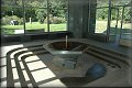
Drinking pavilion in the spa park.
 Konstantinovy Lazne rightfully claim the sites of the
Pilsen Region, often on a quiet unspoilt countryside civilization
is rife acidulous mineral springs. Find here a number of historical
monuments and interesting places, which will allow us to follow the
trail of man from prehistoric times through the Middle Ages to the
present.
Konstantinovy Lazne rightfully claim the sites of the
Pilsen Region, often on a quiet unspoilt countryside civilization
is rife acidulous mineral springs. Find here a number of historical
monuments and interesting places, which will allow us to follow the
trail of man from prehistoric times through the Middle Ages to the
present.
Spa itself is situated in a beautiful park, an assortment of
species naturally follow-up on the surrounding nature. The village
found 35 km west of Plzen where we head towards the Karlovy Vary in
the average altitude of 520 m in one of the ecologically cleanest
regions of Bohemia. With a total of 932 inhabitants one of the
smaller spa towns in the Czech Republic, offering a quiet family
environment for its visitors.
Spa services are mainly focused on a comprehensive diagnosis,
prevention and treatment of cardiovascular diseases. The main
therapeutic methods in Konstantinovych Laznich are based on the
medicinal use of natural resources - mineral carbonated water.
Source of natural iron bicarbonate sodium-magnesium hypotonic
mineral water from a depth of 40 m has a yield of 120 to 150 liters
per minute at a temperature of 9.1 o C and has the highest content
of carbon dioxide in the Czech Republic.
The content of free carbon dioxide in the water here is actually
the highest in the Czech Republic (3638.0 mg / l).
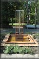
USE OF RESOURCES
Receivers vrt BV 11 - Prusík
BV 11 - 9.9 to 5.26 - 29.54 to 35.45 - 14.67-3136
Proclaimed as a source of natural healing source decree MZ is
situated in the spa park in the previous five original Jimani
spring. It is 40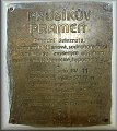 meters deep with a getup: 18.5 meters in earthenware
pipes 450/350 mm perforation of hl.10 m from 18.5 m to 40m then
ANTICORO casing diameter of 216 mm with a perforation.
meters deep with a getup: 18.5 meters in earthenware
pipes 450/350 mm perforation of hl.10 m from 18.5 m to 40m then
ANTICORO casing diameter of 216 mm with a perforation.
Receivers vrt BV 12 - Kokasicky
BV 12 - 8.8 to 5.29 - 49.91 to 16.07 - 31.81-2756
Proclaimed as a source of natural healing source decree MZ. It is
situated in the area of the former Kokasickeho spring in the valley
Polzickeho stream about 1 km west of the village. Depth 40 m deep
with a getup: 18.5 meters in earthenware pipes 450/350 mm
perforation of hl.10 m from 18.5 m to 40m then ANTICORO casing
diameter of 216 mm with a perforation.
Source - Temperature - pH - Fe mg / l - Cl mg / l - SO4 mg / l -
CO2 mg / l
Classification:
Natural, cold, simple, hypotonic, ferrous mineral water,
hydrogen-carbonate-sodium-magnesium type with an increased content
of silicic acid.
GEOLOGY, TECTONICS AND HYDROGEOLOGY, TERRITORY
 Thermal springs Konstantinovy Lazne complex in
northwestern tip Tepelska-barandienske field at an altitude of
about 520 m above sea level in places where Tepelska Flatbed pass
to the southeast in the lower Stribrsko Hills. The emergence of
thermal springs is the result of favorable ratio and the presence
of tectonic mladotretihorniho volcanism. For the overall landscape
is characteristically area parovinny relief with shallow trough
zahloubenymi depression, which contrasts with the deeply incised
valleys greater flow.
Thermal springs Konstantinovy Lazne complex in
northwestern tip Tepelska-barandienske field at an altitude of
about 520 m above sea level in places where Tepelska Flatbed pass
to the southeast in the lower Stribrsko Hills. The emergence of
thermal springs is the result of favorable ratio and the presence
of tectonic mladotretihorniho volcanism. For the overall landscape
is characteristically area parovinny relief with shallow trough
zahloubenymi depression, which contrasts with the deeply incised
valleys greater flow.
Around peneplain emerge from the vital heights neovulkan (Krasikov
629 m , Sheep hill, 696 m, Hradistsky hill 632m).
GEOLOGYCAL TERRITORY
Main geological unit is algonkium and a slight flush far as is rock
permokarbonskeho old. The main building materials territory
Phyllite (complex chloriticko-sericitickych Phyllite with quartz
veins) and a series of roof slates and spilitove series. Rock base
is mostly effloresced. Color solid rock is usually gray-green and
gray. Color depends mainly on the content grafit pigment. The
predominant rock is Tectonics territory
From the tectonic point of view, the Board violated fylitovy
complex disorders of various directions. Directions of gradients
(about 70 80 °) vrstnatosti then explained hydrogeological survey
in 1665 - 1969. The predominant direction of the main faults are S
- J (so-called polzicka - nejvyznamejssi disorder width from
several meters to tens of meters) V - Z (so-called
Konstantinolazensko disorder Pricna the polzickou, takes place over
Lazenska sources and end the polzicke breakdown) SV - JZ (old space
Lazni). As the main tectonic nodes showed areas measured in
borehole BV 12, BV 11 space at a former spa spring and the node
north of railroad tracks in places where they intersect Lazenska
disorder with a direction line SV - south-west, passing through the
area of borehole BV 12th This third node has only theoretical
meaning, and so far, without detailed investigated. In the
direction of the main tectonic line from north to south flows
celivsky and Polzicky stream of flowing mineral water board, whose
catchment (consisting fylitickymi rocks) is virtually
impermeable.
HYDROGEOLOGICAL CONDITIONS
Rocks algon old is her character for water impermeable. For
hydrogeological conditions is therefore essential tectonics of the
territory, which allows leak circulation groundwater. Most active circulation is
logically allowed on the tectonic lines whose prostnost is linked
with the degree of fissured. Spreading rate fissure spring is here
quite small ranging from 0.2 l / sec. and of 0.5 l / sec.
leak circulation groundwater. Most active circulation is
logically allowed on the tectonic lines whose prostnost is linked
with the degree of fissured. Spreading rate fissure spring is here
quite small ranging from 0.2 l / sec. and of 0.5 l / sec.
Great majority of failures allows output of mineral water. Band of
creation is at a depth of 50 to 100 m, sometimes more. Prosta
underground water soaking into the cracks, descends after them in
depth here, and mixes with the juvenile carbon dioxide, water,
which proplyni vodu.Proplynena water then has a greater ability to
pick up from the surrounding rocks and mineral component performs
better on the surface.
According to the basic genetic sorting of mineral springs
Constantine Lazne awards between mainland melc spring with two
thermal springs and mineral water circulation etapovym (descending,
ascending). Konstantinolázensko mineral water have a relatively
small mineralisaci from 300 to 1100mg / l, high levels of free CO2
of about 2500 mg / l (and 3000 mg / l), high content of iron and 60
mg / l. According to the composition belongs to the naked cold
kyselkam.
After the page climatic surroundings Constantine Lazni belongs to
semi-arid areas with average annual rainfall from 500 to 650 mm. It
is caused mainly by affecting the cell precipitation shadow of the
foothills of the Bohemian Forest and Doupovské mountains.
SURVEY TERRITORY
 Be explored territory we could date back to 17th interface
and 18 century, which dates back to the survey work in the vicinity
Bezdruzice a curve. They are however unconfirmed. Serious polls
begin, however, and in the 19 century, when it was made F.V.
Hochstelterem basic geological mapped area. In 1913, the geological
structure territory deals R. Kettner. More detailed survey is the
subject between 1946 and 1948-51. Complete hydrogelogicky probing
took place between 1962 - 1965 Stage I, which was to survey the
character of the search should examine hydrogeological conditions,
identify opportunities in existing geyser base and propose a new
mineral water in the catchment. On the basis of favorable results
was carried out between 1965 - 1969 II. stage. She had to specify
thermal springs as a whole, its geological and hydrogeological
conditions and clarify some details from the previous stage. By the
investigation was, inter alia, to implement a number of exploratory
and two catch-the borehole (BV 11 and BV 12). The work carried out
but was not possible to establish infiltration territory. It is
assumed that the catchment basin consists Celivskeho and Polzickeho
Creek area of 12.3 km2.
Be explored territory we could date back to 17th interface
and 18 century, which dates back to the survey work in the vicinity
Bezdruzice a curve. They are however unconfirmed. Serious polls
begin, however, and in the 19 century, when it was made F.V.
Hochstelterem basic geological mapped area. In 1913, the geological
structure territory deals R. Kettner. More detailed survey is the
subject between 1946 and 1948-51. Complete hydrogelogicky probing
took place between 1962 - 1965 Stage I, which was to survey the
character of the search should examine hydrogeological conditions,
identify opportunities in existing geyser base and propose a new
mineral water in the catchment. On the basis of favorable results
was carried out between 1965 - 1969 II. stage. She had to specify
thermal springs as a whole, its geological and hydrogeological
conditions and clarify some details from the previous stage. By the
investigation was, inter alia, to implement a number of exploratory
and two catch-the borehole (BV 11 and BV 12). The work carried out
but was not possible to establish infiltration territory. It is
assumed that the catchment basin consists Celivskeho and Polzickeho
Creek area of 12.3 km2.
QUESTIONS:
1st Photo coordinates - OPTIONAL
2nd The year of the fountain
3rd In what depth of the hole located
4th Carbon dioxide content in water
5th how big is this area?
Log on to send the reply, or write WRITE NOTE. Do not wait for an
answer, otherwise I get back
CZ:
Prusikuv pramen
Raseliniste se
sirnymi prameny.
Prusikuv pramen: Mineralni
uhlicita voda s prijemnou chuti s nepatrnym sirovodikovym pachem,
teplota 9,9°C.
V pitnem pavilonu v lazenskem
parku.
Konstantinovy Lazne
pravem nalezi k vyznamnym mistum Plzenskeho kraje, klidne o mnohdy
civilizaci jeste nedotcene krajiny prosycene vyvery mineralnich
kyselek. Nalezneme zde radu historickych pamatek a zajimavych mist,
ktere nam dovoli sledovat stopu cloveka od praveku pres stredovek
az po soucasnost.
Samotne lazenske misto je citlive
zasazene do krasneho druhove pestreho lesoparku prirozene
navazujiciho na okolni prirodu. Obec nalezneme 35 km zapadne od
Plzne vydameli se smerem na Karlovy Vary v prumerne nadmorske vysce
520 m v jedne z ekologicky nejcistsi oblasti cech. S celkem 932
obyvateli patri mezi mensi lazenska mista v ceske republice
nabizejici klidne rodinne prostredi pro sve
navstevniky.
Lazenske sluzby jsou zde zamereny
predevsim na komplexni diagnostiku, prevenci a leceni chorob
kardiovaskularniho systemu. Hlavni lecebne metody v Konstantinovych
Laznich jsou zalozeny na vyuziti prirodnich lecivych zdroju -
mineralni uhlicite vody. Pramen prirodni zeleznate
hydrogenuhlicitanove sodnohorecnate hypotonicke kyselky z hloubky
40 m ma vydatnost 120 - 150 l za minutu pri teplote 9,1 o C a ma
nejvyssi obsah oxidu uhliciteho v cele ceske
republice.
Obsah volneho oxidu uhliciteho ve
zdejsi vode je skutecne vubec nejvyssi v cele ceske republice
(3638,0 mg/l).
Vyuzivane zdroje
Jimaci vrt BV 11 –
Prusik
BV 11 - 9,9 - 5,26 - 29,54 -
35,45 - 14,67 - 3136
Prohlasen za zdroj prirodni
lecivy zdroj vyhlaskou MZ Je situovan v lazenskem parku v miste
predchoziho jimani puvodnich peti pramenu. Je 40m hluboky
svystroji: do 18,5 m
kameninove roury 450/350 mm s perforaci od hl.10 m, od 18,5 m do
40m pak anticoro paznice o prumeru 216 mm s
perforaci.
Jimaci vrt BV 12 –
Kokasicky
BV 12 - 8,8 - 5,29 - 49,91 -
16,07 - 31,81 - 2756
Prohlasen za zdroj prirodni
lecivy zdroj vyhlaskou MZ. Je situovan v prostoru byvaleho
Kokasickeho pramene v udoli Polzickeho potoka cca 1 km zapadne od
obce. Hloubka 40 m hluboky s vystroji: do 18,5 m kameninove roury
450/350 mm s perforaci od hl.10 m, od 18,5 m do 40m pak anticoro
paznice o prumeru 216 mm s perforaci.
Zdroj - Teplota - pH - Fe mg/l -
Cl mg/l - SO4 mg/l - CO2 mg/l
Klasifikace:
Prirodni, studena, prosta,
hypotonicka, zeleznata kyselka,
hydrogen-uhlicitano-sodno-horecnateho typu se zvysenym obsahem
kyseliny kremicite.
Geologie, tektonika a hydrologie uzemi
Zridelni struktura
Konstantinovych Laznich lezi v severozapadnim vybezku komplexu
tepelsko-barandienske oblasti ve vysce okolo 520 m n.m. v mistech,
kde Tepelska plosina prechazi na jihovychod do nizsi stribrske
pahorkatiny. Vznik zridelni struktury je vysledkem priznivych
tektonickych pomeru a pritomnost mladotretihorniho vulkanismu. Pro
celkovy raz krajiny je charakteristicky plochy parovinny relief s
melce zahloubenymi udolnimi depresemi, ktery kontrastuje s hluboce
zariznutymi udolimi vetsich toku.
V okoli vystupuji z paroviny
vyznamne kopce neovulkanitu (Krasikov 629 m n.m., Ovci vrch 696 m
n.n., Hradistsky vrch 632 m n.m. atd).
Geologicka stavba uzemi
Hlavni geologickou jednotkou je
algonkium a v nepatrnem plosnem rozsahu rovnez horniny
permokarbonskeho stari. Hlavnim stavebnim materialem uzemi jsou
fylity (komplex chloriticko-sericitickych fylitu s zilkami kremene)
a to serie pokryvacskych bridlic a serie spilitove. Skalni podklad
je vetsinou zvetraly. Barva pevne horniny je vetsinou sedozelene az
sede barvy. Zbarveni zavisi predevsim na obsahu grafitickeho
pigmentu. Prevladajici horninou je Tektonika
uzemi.
Z tektonickeho hlediska je tento
fylitovy komplex porusen radou poruch nejruznejsich smeru. Smery o
sklony (asi 70-80o) vrstnatosti pak upresnil hydrogeologicky
pruzkum v letech 1665 – 1969. Prevladajici smery hlavnich
poruch jsou S – J ( tzv. polzicka – nejvyznamejssi
porucha, sirka od nekolika metru az do desitek metru) V – Z (
tzv. konstantinolazenska porucha, pricna na polzickou,probiha pres
lazenske prameny a konci na polzicke poruse) SV-JZ (prostor Starych
Lazni). Jako hlavni tektonicke uzly se pri mereni projevily
prostory u vrtu BV 12, prostor u BV 11 a byvalych lazenskych
pramenu a uzel severne od zeleznicni trate v mistech kde se
protinaji lazenska porucha s linii smeru SV – JZ,
prochazejici prostorem vrtu BV 12. Tento treti uzel ma jen
teoreticky vyznam a je zatim bez podrobnejsiho prozkoumani. Ve
smeru hlavni tektonicke linie od severu k jihu proteka celivsky a
Polzicky potok z radou vyveru kyselky, jehoz povodi (tvoreno
fylitickymi horninami) je prakticky nepropustne.
Hydrogeologicke pomery
Horniny algonkickeho stari jsou
svym charakterem pro vodu nepropustne. Pro hydrogeologicke pomery
ma proto zasadni vyznam tektonika uzemi,ktere umoznuji
puklinovy obeh spodni vody. Nejaktivnejsi obeh je tak logicky
umoznen na tektonickych liniich, jejichz prostnost je spjata se
stupnem rozpukani. Vydatnost puklinovych pramenu je zde pomerne
mala od 0,2 l/sec. az po 0,5 l/sec.Prevazna vetsina poruch umoznuje
vystup mineralnim vodam. Pasmo jejich tvoreni je v hloubce 50
– 100 m, misty i vice. Prosta podzemni voda se vsakuje do
puklin, sestupuje po nich do hloubky a zde se smesuje s juvenilnim
kyslicnikem uhlicitym, ktery vodu proplyni vodu.Proplynena voda pak
ma vetsi schopnost prejimat z okolnich hornin mineralni slozky a
lepe vystupuje k povrchu.
Podle zakladniho genetickeho
trideni mineralnich zridel nalezi Konstantinovy Lazne mezi
kontinentalni zridla s melci zridelni strukturou a dvou etapovym
obehem mineralni vody (sestupna, vzestupna).Konstantinolazenske
kyselky maji pomerne malou mineralisaci od 300 do 1100mg/l, vysoky
obsah volneho CO2 okolo 2500 mg/l (i 3000 mg/l), vysoky obsah
zeleza az 60 mg/l. Podle slozeni patri k studenym prostym
kyselkam.
Po strance klimaticke patri okoli
Konstantinovych Lazni k polosuchym oblastem s prumernym rocnim
uhrnem srazek 500 – 650 mm. Je to zpusobeno predevsim
ovlivnenim cele oblasti srazkovym stinem predhuri ceskeho lesa a
Doupovskych hor
Pruzkum uzemi
Zahajeni pruzkumu uzemi by jsme
mohli datovat na rozhrani 17. a 18. stoleti, na kdy se datuji
kutaci prace v okoli Bezdruzic a Krivcu. Ty jsou vsak nepotvrzene.
Seriozni pruzkumy zacinaji vsak az v polovine 19. stoleti, kdy bylo
provedeno F.V. Hochstelterem zakladni geologicke zmapovani oblasti.
V roce 1913 se geologickou stavbou uzemi zabyva R.Kettner.
Podrobnejsimu pruzkumu je oblast podrobena v letech 1946 a 1948-51.
Kompletni hydrogelogicky pruzkum pak probehl v letech 1962 –
1965 I. etapou, ktera mela charakter vyhledavaciho pruzkumu mela
overit hydrogeologicke pomery, zjistit moznosti stavajici zridelni
zakladny a navrhnout novy zpusob jimani mineralnich vod. Na zaklade
priznivych vysledku byla provedena v letech 1965 – 1969 II.
etapa. Ta mela za ukol upresnit zridelni strukturu jako celek, jeji
geologicke a hydrogeologicke pomery a upresnit nektere detaily z
predchozi etapy. Soucasti pruzkumu bylo mimo jine i provedeni cele
rady pruzkumnych a dvou jimacich vrtu (BV 11 a BV 12). Z
provedenych praci nebylo vsak mozne presne stanovit infiltracni
uzemi. Predpoklada se, ze infiltracni oblast je tvorena povodim
celivskeho a Polzickeho potoka o rozloze 12,3 km2.
Otazky:
1. Foto na souradnicich
2. Letopocet na fontane
3. V jake hloubce se nachazi vrt
4. Obsah oxidu uhliciteho ve vode
5. Na jake rozloze se nachazi tato oblast ?
Logujte az po odeslani odpovedi, jinak piste WRITE NOTE. Necekejte
na odpoved, ja se kdyztak ozvu.
Ha, pocítadlo zjistilo, jsi  kacer, ktery zrovna brejli na moji kesku. Dik