Update-1/18/15 I, Clugston19, adopted this cache to stop it from being archived due to it's age and historical value. I have left everything the same on the listing and at the cache. Thank you. This Geocache will take you to a mountain top triangulation station. These are a lot like caches in that you can use your GPS to find them. In fact the coordinates are much more accurate than any cache you have ever found. They are within a few centimeters. So you can use them to test your GPS.
There is another type of benchmark where accurate elevation is most important. The listed coordinates on the benchmarking page were estimated from a map. This cache will take you to both types of benchmarks.
Take Route 850 in Perry County to Cove Road. Follow the gravel road which becomes a rock and dirt road to a State Game Lands Parking Area. Be careful if you have a low clearance vehicle. There is a gate across the road. It is open from September 20th to January 10th. If you have a four wheel drive vehicle you can follow the road up to another parking area. I would park in the lower lot if you have a regular vehicle. From the upper parking area proceed through the gate here.
Just ahead and to the right is an example of the vertical (accurate elevation) benchmark. This is V 153 PID KW1910. I found the listed coordinates were 2/10 of a mile off. My coordinates are N 40 20.062 W 077 03.477.
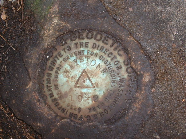
Follow the old road up the mountain. It is about 3/4 of a mile to the top. At the top follow your GPS to the correct trail. It is about a quarter mile to the triangulation station. You will be looking for a disk with a triangle on it. It may be covered with dirt and leaves. It is on a large flat rock. There are two other disks on smaller rocks. They have arrows on them which point to the disk with the triangle on it. The coordinates listed above are for the Triangulation Station Keystone. PID KW 2810
The cache is at a bearing of 65 degrees using true north and a distance of 75 feet from the triangulation station. The cache is in a smaller ammo box.
The cache is in State Game Lands No. 170. For your safety wear blaze orange clothing in hunting season. The Game Commission requires 250 square inches.