After Antarctica, Australia is the driest continent in the world
with approximately 35 per cent of the land mass being desert. Big
Red is on the outskirts of one of these Deserts- The Simpson
Desert. This desert occupies approximately 200,000 square
kilometers of central Australia and is the world’s best example of
dunal desert. It is located within, and near the common boundaries
of the Northern Territory, South Australia and Queensland states of
Australia. It is bounded to the west by the Finke River and Mabel
Range, to the north by the Adam Range, to the east by the Georgina
and Diamantina Rivers, with Lake Eyre to the south. Average annual
rainfall is less than 200 mm.

Around 225 million years ago the region experienced
downwarping and further inundation from freshwater lakes and
rivers, creating the Eromanga Basin. The sediments from this basin
overlaid those of the Pedirka basin creating a seal. During the
Jurassic, coarse sands were laid down, these now form the aquifers
of the Great Artesian Basin.
During the Cretaceous period the Eromanga Basin sagged and
Australia became two islands flooded by the Cretaceous Sea. Marine
sediments were laid down, and these formed a capping over the
coarse Jurassic sands, thus, over a period of 150 million years,
the Great Artesian Basin was formed.
In the early Tertiary, around 70 million years ago there was
further downwarping in the area creating the Lake Eyre Basin, the
area covered with shallow lakes and floodplains into which flowed
meandering rivers. The deposits from these form a layer of sediment
up to 200 meters thick that sits beneath today’s dunefield. Major
fluctuations in climate occurred during the Pleistocene around 1.8
million years ago, and the lakes and rivers dried up.
The modern dunefields are infants in geological terms.
Stratigraphic sectioning and fossil dating suggests that dunefield
building commenced within the last 18,000 years, some scientists
suggest as recently as 8-10,000 years ago during the early
Holocene.
The explorer Charles Stuart Hutton, who visited the region from
1844-1846, was the first European to see the Simpson desert, but it
was not until 1936, that Ted Colson became the first white person
to cross it in its entirety. The name Simpson Desert was coined by
Cecil Madigan, after Alfred Allen Simpson, an Australian
philanthropist, geographer, and president of the Royal Geographical
Society of South Australia.
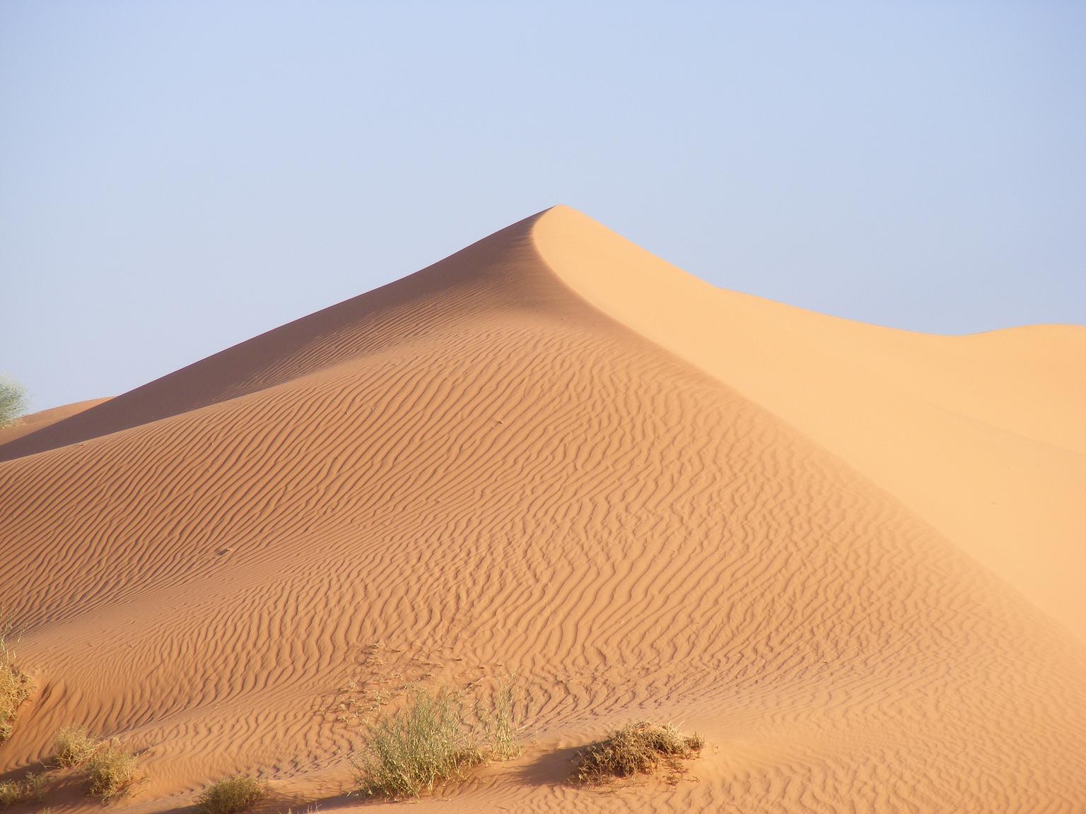
The Simpson Desert is an ecoregion which contains the world's
longest (up to 200 kilometres) parallel sand dunes. These
north-south oriented dunes are static, held in position by
vegetation such as cane grass which thrives on the deep sands along
the crests of the dunes. The dunes vary in height from 3 meters in
the west to around 30 meters on the eastern side. The most famous
dune, Nattanepica, or, more popularly known as Big Red. The
spectacular Big Red (named by Simpson Desert traveler Dennis
Bartell) is a sand dune of immense proportions and is 40 meters in
height.
There are 3 distinct types of sand dunes – the mobile, stationary
and semi-active sand dunes. Mobile sand dunes are completely bare
of any vegetation and as such move about over time with the wind.
Similarly stationary sand dunes often do not have any vegetation
however the prevailing winds are not strong enough to move more
sand then they deposit and as such the dune grows quite tall.
Semi-active sand dunes are mobile and stationary at the same time.
The bulk of a dune is anchored, often by a clay-cemented core; its
flanks are stabilised by vegetation: low bushes and grasses. But
where there is loose sand on the top of dunes, it moves in a slow
process.

Once it's in motion, sand will continue to move until an obstacle
causes it to stop. The heaviest grains settle against the obstacle,
and a small ridge or bump forms. Because the obstacle breaks the
force of the wind, the lighter grains deposit themselves on the
other side of the obstacle. Eventually, the surface facing the wind
crests, and the lighter grains of sand cascade down the other side,
or the slip face. This is how a sand dune may actually move over
time -- it rolls along, maintaining its shape as it goes.
How and why does a sand dune crest? As the wind moves sand up to
the top of the sandpile, the pile becomes so steep it begins to
collapse under its own weight, and the sand avalanches down the
slip face. The pile stops collapsing when the slip face reaches the
right angle of steepness for the dune to remain stable. This angle,
which scientists call the angle of repose, is usually about 30 to
34 degrees.
After enough sand builds up around an obstacle, the dune itself
becomes the obstacle, and it continues to grow. Depending on the
speed and direction of the wind and the weight of the local sand,
dunes will develop into a different shapes and sizes. Stronger
winds tend to make taller dunes; gentler winds tend to spread them
out. If the direction of the wind generally is the same over the
years, dunes gradually shift in that direction. Any vegetation that
crops up will stabilize the dune and prevent it from shifting.

The colour of the sand itself is a result of oxidation and ranges
from blinding white to pink to a deep red glow. It is pale close to
its source: on the floodplains, and along the river courses; it
becomes redder the further away from them. The colouring process is
caused by a mix of minute clay particles with oxides of iron and
manganese brought in by wind and rain. The oxidation is very slow
and the deepest red is attained only after thousands of years and
under an absence of humidity. The dark red sands - at the greatest
distance from their source - have simply been around for longest.
The sand has rusted.
This wonder of the outback is definitely worth seeing and provides
an excellent challenge for all visitors. Big Red is the first of
1140 sand hills (heading west).
To log this Cache please email me the answers to the following
questions and a photo of yourself atop Big Red track showing the
dune behind you.
- In which direction does the prevailing wind come from?
- From GZ out of the visible sand dunes, east and west, which is
the oldest?
- Which definition does Big Red come under as a dune? Active,
Semi-Active or Stationary?
- Has Big Red been formed by a strong or a gentle wind?
| I am a proud |
 |
The above information was compiled from the following sources &
personal Photos:
-
http://www.nationalgeographic.com/wildworld/profiles/terrestrial/aa/aa1308.html
- http://en.wikipedia.org/wiki/Simpson_Desert
- http://www.theoutback.com.au/big-red-sand-dune/23/
- http://www.kidcyber.com.au/topics/simpsdest.htm
-
http://geography.howstuffworks.com/terms-and-associations/sand-dune1.htm
-
http://simpson-desert-trek.blogspot.com/2008_12_01_archive.html