This EarthCache will highlight a spectacular location in the Allegheny National Forest, Hector Falls.
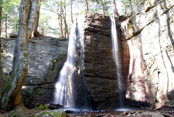
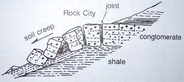
Here we will focus on the rock city around the falls and how this resulted in a slightly different type of waterfall. A rock city is a group of very large seemingly randomly placed rocks forming a city like area where the rocks seem just like buildings with passages, streets, tunnels, and sometimes even caves among them. It is worth noting here that these are not true caves by definition but rather rock shelters. Formation of rock cities begin when flat-lying beds of erosion resistant conglomerate or sandstone, sitting above weaker less resistant beds of shale or siltstone, begin to separate along natural fractures, called joints, formed by the stress placed on these rocks when they were buried under other sedimentary layers. The constant assault of water entering cracks, freezing, and thawing is mainly responsible for these blocks being split apart. Tree roots that penetrate the blocks along with frost-wedging have continued to break down these large blocks. Once the blocks were split off of the parent ledge a combination of water and gravity handled the rest. The ground became saturated with water in heavy rains and spring thaws and it slowly carried these large blocks, down the slope from the ledge, to their current position. This process is generally known as soil creep. All of the massive boulders you will encounter once you get to the falls are Pennsylvanian age Pottsville group conglomerate and sandstone.
Hector falls is quite unique in that while most waterfalls are formed as a stream encounters and then drops over an existing resistant rock layer, this is the only example I can think of where a stream drops over the sandstone and conglomerate cliffs and boulders found all throughout the Allegheny National Forest. Most of the streams are not large enough to create a waterfall and those that are usually find a path through the cracks and joints rather than over the edge. You can actually see evidence of this beginning to happen here as the majority of the stream flow usually passes through a large crack to the left. In low water this is usually the only place the water flows over the falls.
Listed coordinates are for the parking area. From the parking area at the junction of Forest Roads 258 and 258H you will proceed down FR 258H, on foot... even if the gate is open, and after passing a deer fence and old gravel quarry on the right you will come to a fork in the road. You will take the left fork downhill and keep to the road until you reach a blue gas well at the end of the road. Just off to the right, beyond the rocks at the edge of the clearing, the trail follows along Hector's Run to the top of the falls. It is worth noting that there is no real trail to the bottom of the falls and there are massive boulders to navigate around but for the purpose of photographing the falls you will want to be at the bottom. It is possible to get to the bottom from either side of Hector's Run and there is a trail heading down toward the bottom for a while if you are heading down from Hector's Spring Version 2 but it vanishes before reaching the bottom. There is a drop of over 20 feet near the top of the falls. In the interest of safety please be careful and do not go too near the edges. This trip should be fine for children if well supervised. I have provided waypoints for some of the turns along the way because if you don't follow them you will not get there. Coordinates for the falls and turns along the way are listed in the additional waypoints section below. Some of the roads may not be passable in snow or mud.
Be sure to check out Hector's Spring Version 2 while you are in the area.
Types of Waterfalls:
Waterfalls that remain in contact with the underlying rock:
Cascade: generally water that flows down in small steps or stages.
Chute: A violent section of water that is forced through a narrow passage due to cliff walls or large rocks.
Fan: falls through a relatively narrow crest and spreads out and becomes wider as it descends.
Horsetail: descends down remaining in contact with the surface most of the time.
Scree/Talus: flowing over a chaotic mix of rock debris on a slope usually found at the base of a cliff or steep incline.
Slide: glides over a single slab of rock maintaining smooth continuous contact.
Waterfalls that separate from the underlying rock:
Block/Sheet: drops over a ledge forming what appears to be a "sheet" of water - usually not broken into segments and it is wider than it is tall.
Cataract: waterfall that is large, very powerful and rushes down with force.
Classical: similar to Block, but roughly equal in height and width
Curtain: similar to Block, but typically taller than wide.
Plunge: descends vertically without contacting the underlying surface.
Punchbowl: falls through a constricted area and descends down into a pool of water.
Veil: falls over rocks creating a thin layer of water that just barely covers it's surface.
Other Descriptive Types:
Parallel: falls are side-by-side and fall similar to each other.
Ribbon: descends in a narrow strip significantly taller than it is wide.
Segmented: Pieces of land segment the river (same watercourse) causing the water to fall in sections.
Slot/Keyhole: pushes through a narrow area before falling.
Tiered: Separate waterfalls falling consecutively and in close proximity so generally they can be seen together. Any type of falls can be tiered.
Twin: side-by-side but do not have to be similar in type. (Triple and more can exist as well)
Waypoints:
Parking Area/Trailhead - Posted Coordinates
Hector Falls - N 41 41.118 W 078 58.504
Turn onto Hillside Street - N 41 43.914 W 078 56.841
Left onto Water Street - N 41 43.872 W 078 56.969
Right onto Forest Road 133 - N 41 43.713 W 078 56.833
Right onto Forest Road 258 - N 41 42.919 W 078 57.032
Gas Well - N 41 41.269 W 078 58.508
To claim this as a find:
1. Post a photo of yourself and your GPS with Hector Falls in the background. (Optional but appreciated)
2. Classify the falls using the above descriptive types.
3. How many distinct paths is the water taking over the falls at the time of your visit?
4. Use your log to provide, in your own terminology, a quick description of the current weather conditions, and their affect on the amount of water flowing over the falls.
E-mail the answer to me for numbers 2&3, and post the answer to number 4 with your log within a few days. Failure to comply with these requirements will result in log deletion.
Good luck and good caching.
- Rev Mike
|
|
NWPA Geocachers : Northwestern Pennsylvania's Geocaching Organization : Learn More.
|