The Torrent de Pareis is one most famous slot canyon carved by
erosion in the Mediterranean Sea area.
This slot canyon is located on Majorca, one of the Balearic
Islands and gives us an impressive demonstration
of a creek's erosive force, in the upper Aerea also the
Denudation.
Majorca is basically composed of clay,dolomite and limerock of the
*Mesozoic era*
The lime stone was eroded to various karstic sculptures like lime
flutes, caves and canyons.
As the gradient of a creek or river is reduced on it's way from
spring to mound,
its ability to move material by waters force is weakened
downstream. When upstream sand and gravel is moved with the
water,
later at the mound only smal l airborne particles are transported
by
the water,so the material which cannot be transported, sags down
and builds sediments.
By this the river bed gets carved in two directions: carving out in
depth is called deep erosion,
broadening of the river bed is called "site-erosion".
The residues of this erosion process gets crushed by chemical and
phyisical gets washed away
so a canyon or valley is being carved out of the stone.
Over long time geologic period an area can be influenced by
alternating erosional and sedimental appearance -
in most cases caused by tectonic lifting and sinking activities of
the earth's crust
This changing between erosion and sediment apearance you can
identify by typical patterns of sediment stones, called
unconformity.

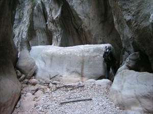
To log this Earthcache take an Photo of you at N39 51.140 E2 48.347
in front of the Sea, and goes to
the Rock formation near by N39 50.905 E2 49.041 (see the picture)
an mail me how high and how thick
the big Rock Wall in your estimation is
Der Torrent de Pareis ist einer der bekannteste Erosionsschluchten
im Mittelmeer.
Dieser Canyon liegt auf der spanischen Baleareninsel Mallorca und
demonstriert auf eindrucksvolle Art und
Weise die Flusserosion (fluviatile Erosion) des Gesteins im oberen
Bereich auch die Denudation.
Hauptsächlich besteht Mallorca aus Mergel, Dolomiten und vor allem
aus Kalkgestein des Erdmittelalters.
Das Kalkgestein wurde ausgewaschen und bildet Karstformen wie z.B.
Kalkrinnen, Höhlen und Schluchten.
Da das Gefälle von Flüssen in Richtung Mündung abnimmt, wird auch
ihre Fähigkeit zum Materialtransport immer geringer.
Werden anfangs noch Kiesel und Sand mitgeführt, sind es im
Mündungsbereich oft nur noch Schwebeteilchen.
Alles Material, für das die Transportkraft nicht mehr ausreicht,
wird abgelagert (Sedimentation).
Die damit einhergehende Vertiefung des Flußbettes wird als
Tiefenerosion, seine Verbreiterung nach der Seite
als Seitenerosion bezeichnet.Der durch Verwitterung chemisch und
physikalisch zerkleinerte
Untergrund (Gestein, Boden) wird weggeschwemmt (Abtragung), was im
Laufe von Jahrtausenden zur Bildung von Tälern
(Tal) führt. Über längere geologische Zeiträume hinweg kann es in
einem Gebiet zu mehrfachem Wechsel zwischen
Erosions- und Sedimentationserscheinungen kommen, meist verursacht
durch tektonische Hebungs- und
Senkungsvorgänge der Erdkruste und deren Auswirkung auf das
Flussgefälle. Diese Wechsel aus
Sedimentations- und Erosionsphasen zeigen sich im verbleibenden
Sedimentgestein als typische Strukturen, den
Erosionsdiskordanzen (Diskordanz).
Um diesen Cache zu loggen mache ein Photo von dir bei N39 51.140
E2 48.347
mit dem Meer im Hintergrund und maile mir wie hoch und wie tief die
Stein-Wand
auf dem Bild, etwa bei N39 50.905 E2 49.041 nach Deiner
Einschätzung ist.
