 El Chorro is Famous for the three artificial
turquoise coloured lakes that were created when the dam was
built across the Guadalhorce river gorge, this spectacular
gorge known as the Garganta del Chorro regularly has eagles
soaring high above the cliffs.
El Chorro is Famous for the three artificial
turquoise coloured lakes that were created when the dam was
built across the Guadalhorce river gorge, this spectacular
gorge known as the Garganta del Chorro regularly has eagles
soaring high above the cliffs.
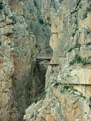
There is a small bridge across the gorge named the Camino del
Rey (The Kings Path), as this mammoth engineering project was open
in 1924 by King Alfonso XIII of Spain.
The steep walls of this gorge are vertical beds of limestone.
The age of these rocks are not a problem - marine fossils place
them accurately in the Jurrassic era. Ammonoids contained in them
in particular allow the dating of some of these beds with an
accuracy of about 1 million years.
Messinian marine deposits of the Guadalhorce River valley in
southern Spain record evidence of the last northern gateway that
existed between the Mediterranean and the Atlantic. They comprise
sandstones and conglomerates with unidirectional cross-bed sets up
to nearly 1 km long in their down-sedimentary-dip direction. These
cross-bed sets relate to extremely fast (1.0-1.5 m s-1) bottom
currents flowing from the Mediterranean into the Atlantic. The
Guadalhorce gateway (which had a maximum width of 5 km and a
maximum water depth of 120 m) was an important element controlling
the Messinian pre-evaporitic oceanic circulation in the
Mediterranean Sea, as it acted as a major outflow channel. Its
closure limited the exchange of water between the Atlantic and the
Mediterranean to the Rifian corridors of Morocco, inducing
water-mass restriction and stratification in the western
Mediterranean immediately prior to the `Messinian Salinity
Crisis'.
To log this EarthCache go to the posted coords and post a
picture of yourself and your gps with the railway bridge and the
gorge and mail me the answers to these questions.