In Madeira, as in many parts of the world, flash floods can occur through a combination of geomorphology (the shape / curtosis of the land), geology (the nature of the rocks that underlie the landform) and climate (the atmospheric conditions which may cause storms which result in the erosion of the rocks & landforms. This earthcache looks at some of these aspects from a geological perspective at the capital and main tourist centre of Madeira, which sadly experienced such a flood in 2010 .
The Background
The Madeiran archipelago is a group of sub-tropical islands of volcanic origin, having been created by eruptions that started 20 million years ago over a hotspot in the Earth’s crust on the edge of the African tectonic plate. Porto Santo is the oldest (around 14 million years) and Madeira is younger (around 5 million years).
There have been 5 main phases related to the formation of the group:-
The large early eruptions, which ended about 3 million years ago, were mostly explosive pyroclastic ones forming ash layers, scoriae, tuffs & bombs. Later more perpheral, effusive lava flows gave rise to fine grained basalt layers, overlying the softer rocks and penetrating into them as vertical dykes or horizontal seams. When the cooling was especially rapid, characteristic columnar jointing appeared in the basalt. This phase terminated about 740,000 years ago. The higher mountains continued to form from projectiles and pyroclastic materials and the Paul da Serra plateau formed around 550,000 years ago. There have been a few more recent eruptions which terminated about 6,500 years ago and these are associated with minor island formations and the cone-shaped hills visible to the west of Funchal.
So the island rose over 5000 metres from the ocean floor, although only 2/5ths are visible above the sea.
Coastal erosion means that the island of 728 square kilometres is mostly surrounded by steep cliffs and the interior is rugged and precipitous.
Rainfall is generally light and falls mostly on the northern and western coasts, but storms can occur and cause flash-flooding as the water cascades down the precipitous mountainsides. Near habitation most of the water courses or "ribieras" have been canalised into confined concrete channels. The ones in the capital Funchal used to be famous for the colourful Bougainvillia & other flowering climbing plants that trailed along wires across the tops of these channels.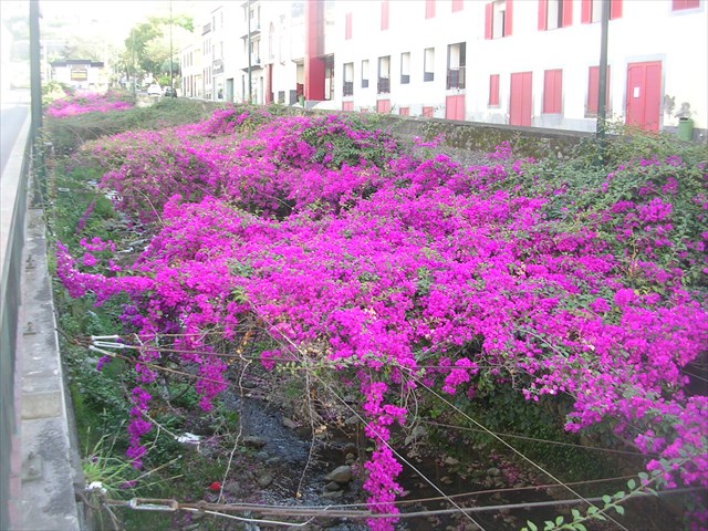
Alas these are no more!
The Problem
Most of these ravines are wider at their inland sources, where there is softer volcanic material, and they narrow towards the sea where they encounter more resistant rocks.
When there is greater than average rainfall, the water levels in the ribeiras can rise dramatically.
If it were just the water, then the ribeiras would probably be able to cope but fast flowing streams cause erosion, both downward, deepening the valley, and headward, extending the valley into the hillside.
Hydraulic action occurs when the motion of fast flowing water against rock surfaces produces mechanical weathering. The moving water is able to dislodge and transport rock particles, which in turn cause a number of specific erosional processes, including abrasion, attrition, corrasion, saltation, scouring, & traction.
Once loosened the smaller particles of rock are held in suspension by the force of the flowing water and these suspended particles can scour the sides and bottom of the stream. The scouring action can produce distinctive markings on streams beds such as ripple marks, fluting, and crescent marks.
Larger particles, rocks & boulders are scooted or dragged along the bottom in a process known as traction which causes attrition, and are often "bounced" along in a process known as saltation where the force of the water temporarily lifts the rock particle which then crashes back into the bed dislodging other particles.
As a torrent surges downwards the turbulence can compress air which might be trapped in cracks in the soil or rocks or force air bubbles into the banks at the side of the river. This exerts pressure on the surrounding materials which can progressively crack, break, splinter and detach.
This can often be followed by a rapid decompression of the air as the water falls back and this can often occur suddenly with explosive force which additionally weakens the rock.
Cracks are gradually widened so the amount of compressed air increases, and hence the explosive force of its release increases. Thus, the effect intensifies in a 'positive feedback' system.
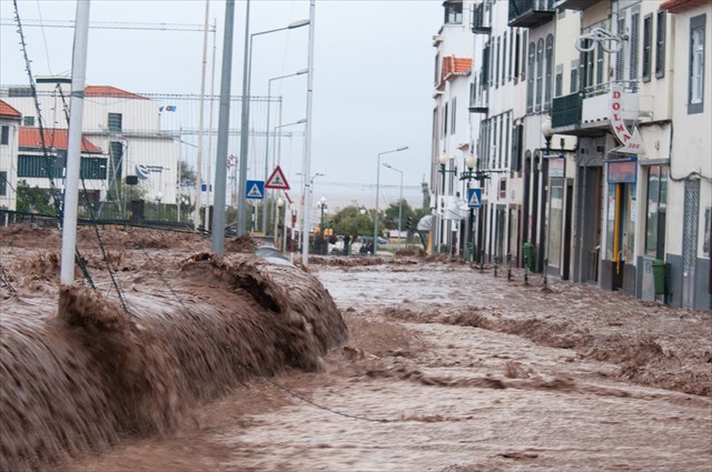
It is this hydraulic erosion which causes the ribeiras to carry lots of soil, mud and boulders, not to mention uprooted trees or vehicles as well as the water load.
These solid objects often cause a jam under bridges or near the mouth of the ribeira, causing the water to overflow the channel and flood into the surrounding streets. This is of course where the largest concentration of homes and businesses have been built and is often where people become trapped by the rising waters.
Such happened in Funchal on 21st February 2010 when the floods were so sudden that sadly people lost their lives. That day 108 mm (4¼ inches) of rain was recorded at Funchal weather station and 165 mm (6½ inches) of rain at the weather station on Pico do Areiro between 6 a.m. and 11 a.m. local time.
The average rainfall in Funchal for the whole of February is 88.0 mm (3½ inches) so more than would normally fall over 12 or 13 days actually fell in 5 hours! The floodwaters badly damaged some buildings, overturned cars, knocked down trees and at least 76 people were killed.
More than 120 people were injured and approximately 200 people were displaced. The damage amounted to about 1.4 billion Euro in total but was confined to the southern half of the island. This might be related to the levadas, which carry water from the north coast to the south, or because of the wind and storm direction.
The rainfall was associated with an active cold front and an Atlantic low-pressure area that was over the Azores and moved northeastwards on 19 February. This storm was one in a series of storms that affected Spain, Portugal, Morocco & the Canary Islands with flooding, rain and high winds.
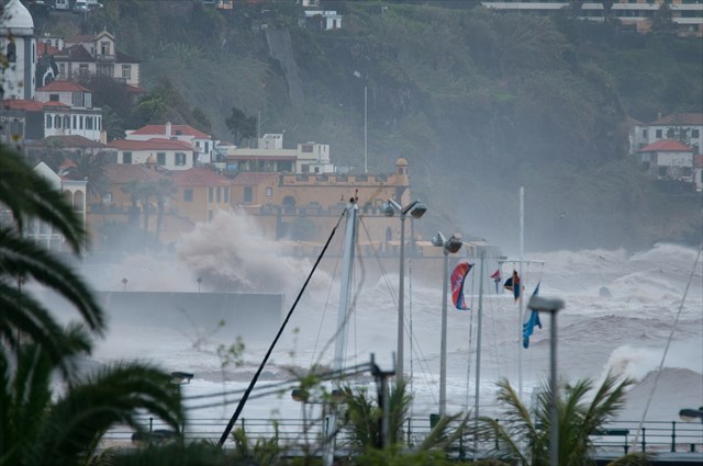
These storms were bolstered by an unusually strong temperature contrast of the sea surface across the Atlantic Ocean. Abnormally warm waters had been widespread off West Africa, whereas relatively cold surface waters had stretched between western Europe and the southeastern USA. The storm was also exacerbated by the eruption cloud of the Soufrière Hills volcano on the Caribbean island of Montserrat.
Reconstruction and cleaning work started a few hours after the rainfall. On the same day, several dozen units of heavy machinery and trucks were seen in the streets of Funchal and other major affected sites, cleaning streets as well as removing rocks and mud accumulated in the "ribeiras". In the next few days this number peaked to several hundred heavy units and trucks operating in all affected sites. In spite of some access restrictions in the centre of Funchal and some other parts of the island, all services were soon fully functional and normal life was restored. No tourist resorts were affected by the event, except for a few small hotels inland where some blocked roads caused access restrictions.
However, full restoration of all affected infrastructure will take some time and you can still see the effects of the 2010 floods at the listing co-ordinates today - temporary concrete blocks line large sections of roadside where railings have been swept away and the Bougainvillia cover is no more.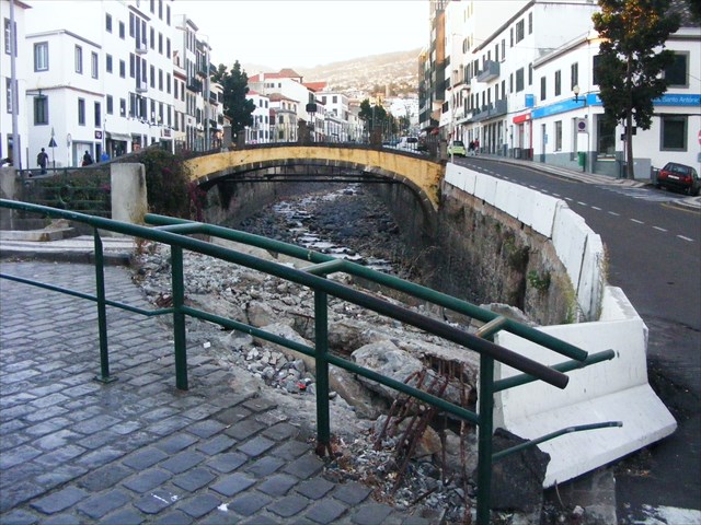
The problem was especially bad at Funchal as 2 channels, Ribeira Santa Luzia and Ribeira de Joao Gomes, converge in a V almost at the coast. Because the gradient is less near this convergence, the huge boulders built up into a natural dam here, trapping motor vehicles, trees and other debris swept down in the flood, causing the channels to overflow.
The Solution
Since 2011 massive civil engineering works are being carried out to reduce the risk of another such catastrophe happening again. The ribeiras are being reconstructed to reduce the chance of a boulder jam occuring in future and some of the tasks associated with this earthcache will have to change as the repair work is completed.
The Tasks
To log this earthcache e mail me the answers to the following questions:-
1) What is the most likely nature of the resistant rocks that cause the ribeiras to narrow near the Madeiran coast? Do you think it would be basalt, granite, limestone, marble, rhyolite, sandstone or tuff?
2) What shape valley (cross section) does vertical erosion by rivers usually create?
3) Look on the internet and tell me the difference between "Corrasion" and "Attrition" - the spelling is correct!
4) There are other types of water-facilitated erosion apart from hydraulic action. Name one such type and say whether or not you think it is likely to very important on Madeira and why.
5) Near the listing co-ordinates you can see damaged concrete and missing railings at the footbridge Ponte do Cidrao over the Ribeira Santa Luzia. However, I believe this bridge is completely boarded off at the moment while work is being done on the flood defences. Geocachers should therefore perform the on-site observations (which are an essential part of any earthcache) at the next bridge up the road, Ponte Dom Manuel, which is still accessible at the moment.
Estimate the width and depth of the channel at the bridge, perhaps by pacing across it & thinking of how many 2 metre humans you could stack up vertically against the wall. Multiply the two figures to get its cross section capacity and, assuming it was filled to the top with flood water flowing past at 1 metre per second, calculate how many cubic metres (or tonnes) of water would pass under the bridge in an hour? (As 1 m3 of water weighs a tonne, the weight of water that would be carried by the channel would be the same as the volume)
7) There are boards keeping people away from the major excavations which say what the minimum dimensions at the narrowest section will be when they are finished. You need to find these boards to be able to tell me what will be the future gradient and minimum depth.
8) The pavements nearby are very colourful with small stones of contrasting colour set in concrete in different patterns. The darker stones are local rock from the island but the lighter ones have been imported from the Iberian Peninsula.
Describe the nature of these 2 stones i.e. colour, uniformity and what crystaline structure if any is visible. From this and other information provided in the listing, state what rock types they are most likely to be.
As per the January 3013 EarthCache guidelines, you may log the cache at the same time as you e mail me the answers and you have to option of uploading of a photo of yourself at the works in Funchal along with your log to prove you reallyvisited the site.
I will contact you if any of your answers are incorrect or need more details.
A Note on the History of Flooding Events on Madiera
There is only one record of a flash flood in the 18th century and just 2 such events in the 19th century. Yet in the 20th century 6 flash flood / landslide events occured and the new century does not appear to have changed this apparent trend to more frequent extreme events with floods which caused fatalities already recorded in 2001 and 2010.
More information on the history and causes of such incidents on Madeira, if you wish to read it, can be found in the 12 page scientific paper by D. Baioni via the 'related webpage' link at the top of the listing.
As Tarefas
Para registrar este e-mail e earthcache me as respostas para as seguintes perguntas: -
1) Qual é a natureza mais provável das rochas resistentes que fazem com que as ribeiras para estreitar perto da costa madeirense? Você acha que seria basalto, granito, calcário, mármore, riolito, arenito ou tufo?
2) Que forma do vale (seção transversal) faz erosão vertical, rios geralmente criam?
3) Procure na internet e me dizer a diferença entre "Corrasion" e "atrito" - a grafia está correta
!
4) Existem outros tipos de erosão hídrica facilitada para além da acção hidráulica. Nome um tal tipo e dizer se está ou não acho que é provável que muito importante na Madeira e por quê.
5) Perto da listagem coordena você pode ver concreto danificado e trilhos perdidos na Ponte passarela que Cidrao sobre o Santa Luzia Ribeira. No entanto, eu acredito que esta ponte está completamente fora abordado no momento enquanto o trabalho está sendo feito sobre as defesas contra inundações. Geocachers devem, portanto, realizar as observações no local (que são uma parte essencial de qualquer earthcache) na ponte próxima a estrada, Ponte D. Manuel, que ainda está acessível no momento.
Estimar a largura e profundidade do canal na ponte, talvez pela estimulação através dele e pensando em quantos seres humanos 2 metros você pode empilhar verticalmente contra a parede. Multiplique os dois números para obter a sua capacidade seção transversal e, supondo que ele estava cheio até o topo com água da inundação fluir após a 1 metro por segundo, calcular quantos metros cúbicos (ou toneladas) de água passaria por baixo da ponte em uma hora? (Tal como 1 m3 de água pesa uma tonelada, o peso da água que seria transportado pelo canal seria o mesmo que o volume)
7) Há placas de manter as pessoas longe das escavações importantes que dizem que as dimensões mínimas na parte mais estreita seção será quando terminar. Você precisa encontrar essas placas de ser capaz de me dizer o que será o gradiente futuro e profundidade mínima.
8) As calçadas próximas são muito coloridos com pedras pequenas de cor contrastante em concreto estabelecidas em padrões diferentes. As pedras mais escuras são rock local da ilha, mas os mais leves foram importados da Península Ibérica.
Descrever a natureza destas duas pedras ou seja, a uniformidade de cor e que a estrutura cristalina, se algum é visível. A partir desta e de outras informações fornecidas no anúncio, estado que tipos de rochas que são mais susceptíveis de ser.
Conforme as diretrizes janeiro 3013 EarthCache, você pode registrar o cache ao mesmo tempo que você me e-mail as respostas e você tem a opção de fazer o upload de uma foto de si mesmo com as obras em Funchal, juntamente com o seu registo para provar que o reallyvisited site.
Entrarei em contato com você, se algumas de suas respostas estão erradas ou precisar de mais detalhes.
CONGRATULATIONS TO dandrade (a Madeiran) WHO WAS THE FIRST PERSON TO SUBMIT THE ANSWERS NECESSARY TO LOG THIS CACHE AS A 'FIND'. AS WELL AS "FIRST TO FIND" HE MIGHT ALSO BE THE "LAST TO FIND".