Welcome to a combination 21-mile road tour and under 30
minute hike through the pretty NE Columbia County countryside.
You'll visit five covered bridges. Answer a question at each bridge
to determine the coordinates for an ammo box hidden in State Game
Land SGL#55. Hunting in process in SGL's. Wear flourescent
orange. Be careful.
 Kid Friendly Kid Friendly  Dogs Allowed Dogs Allowed
 Hunting in SGL - use caution
  Scenic View Scenic View  Ticks Ticks |
|
|
See the 3 other companion Columbia County Covered Bridge caches.
They allow you to tour the entire county. Each of the 4 cache tours
stands on its own. Each tour takes you through a different scenic
area of the county and includes a short hike to an ammo box in a
different, nearby SGL.
If you plan ahead, you can link all 4 caches in one giant loop.
See the Bridge Locator Maps below. Or you can do each of the 4
tours on its own. One map shows all 4 tours for an overview. The
other shows the tour for the cache on this page. The maps postd
below aren’t necessary for the tours although they are good
for orientation. The coordinates for each bridge are given below.
However, a detailed road map or auto-navigation will be very
helpful to get you around. The county has a nice brochure with
detail map you can download in PDF. Again, it's not necessary to do
the cache.<<BR>
http://www.itourcolumbiamontour.com/covered_bridges_map.pdf
or have mailed to you
http://www.itourcolumbiamontour.com/mail.html
Also nice, although not mandatory, are the SGL topo maps
here:
http://www.pgc.state.pa.us/pgc/game/maps/default.asp?rgn=Northeast
Select the SGL by number to download a PDF map file.
Or be adventurous and skip the maps and follow the arrow on your
GPS! You might get a little lost, but each turn will provide
another nice surprise.
If you enjoy tours like this one, check out my
other covered bridge caches.
Good luck. Take your camera. Take your dog. Take your kids
– all the caches have nice goodies for young and old.
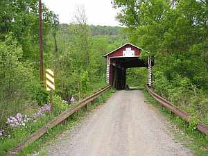
Start at this bridge:
A. Kramer Covered Bridge N41 07.268 W76 25.918 The
Kramer Covered Bridge was recently re-built. My thanks to Ken18621
for the update and the new quiz question.
Kramer quiz- What number is posted above the entrance
portal?
1. 112
2. 113
3. 114
ENTER A answer (1, 2 or 3) = ________
B. Patterson Covered Bridge N41 06.572 W76 25.038
spans 82 feet across the Green Creek. Located near Orangeville, it
was built in 1845.
Patterson quiz- What caution does the yellow sign indicate as
you enter the bridge from the west?
1. Max Clearance 9 Ft. 6 In.
2. Yield to Oncoming Traffic
3. One Lane Bridge.
ENTER B answer (1, 2 or 3) = ________
C. Stillwater Covered Bridge N41 09.120 W76 22.036
is single span Burr Arch with a total length of 168 feet. It is on
Fishing Creek Road over Fishing Creek Branch in Stillwater. This
historic bridge was built in 1849 and is currently closed to motor
traffic.
Stillwater quiz- What number is posted above the entrance
portal?
1. 134
2. 135
3. 136
ENTER C answer (1, 2 or 3) = ________
D. East and West Paden Covered Bridges N41 06.436
W76 21.418 - or The Twin Bridges- The only twin covered bridges in
the United States, are located on Huntington Creek in Fishing Creek
Township. Note that the West Paden was washed away on June 28, 2006
due to the heavy rainfall and flooding. The pictures below show the
before and after the flood views and the repair bridges' view as
well. (pictures are not required to answer the question).
East & West Paden quiz- What is the name of the builder at
the bottom of the plaque located between the two bridges?
1. John S. Veracik
2. Paul E. Kelchnek
3. Forrest Gump
ENTER D answer (1, 2 or 3) = _______
E. Joshuah Hess Covered Bridge N41 06.855 W76
20.343 is a single span Burr Arch with a total length of 110 feet.
It carries Fishing Creek Road over Huntington Creek in the east of
Forks PA. This historic bridge was built in 1875. There are picnic
tables inside – obviously it’s closed to vehicular
traffic. A portable toilet is located next to it to use before you
tackle the hiking portion.
Joshuah Hess quiz- What is one of the name at the bottom the
copper Warning sign on the right side of the entrance portal?
1. John S. Cooper
2. Willard H. Kile, Sr.
3. Frank T. Chatham, Jr.
ENTER E answer (1, 2 or 3) = ________
Cache Coordinates:
Enter the number for each of your five answers and add them
up:
A_______ + B _______ + C _______ + D_______ + E _______
= Total ________
The coordinates for the cache are determined by your total. Only
one set of coordinates is correct.
If your total is 7, the cache coordinates are: N41 06.985 W76
15.146
If your total is 8, the cache coordinates are: N41 06.971 W76
15.047
If your total is 9, the cache coordinates are: N41 06.968 W76
15.018
If your total is 10, the cache coordinates are: N41 06.980 W76
15.112
If your total is 11, the cache coordinates are: N41 06.962 W76
14.986
If your total is 12, the cache coordinates are: N41 06.947 W76
14.947
Start your hike from parking here in SGL #55. N41 06.840 W76
14.880
Cache is on State Game Land. Wear orange during hunting
season.
The pictures are NOT spoilers. Go ahead and add your own.
Encrypted hint beneath poem.
___________________________________________________________
The Old Covered Bridge....
Driving down the winding road
I came upon some trees that fold
their arms so gracefully around
the winding curves that seem to abound.
In the dark distance peeking it’s face
is the smiling opening of a lonely place.
As I get closer I start to cringe
then realize... it is only a covered bridge
A covered bridge of such ancient beauty
brings back the memories of life and duty.
With horses and buggies the travel was slow.
life was so simple, to church they would go.
Even now the covered bridge is used each day.
The people who live there must travel both ways.
To go to school the bridge is crossed by bus.
If we go to work or for groceries it is crossed by
us.
The sun shines on the bridge and makes it glow
with a halo of love and warm feelings from the soul.
The old bridge offers such a lovely nostalgic feeling
to bring back the memory of past life’s dealings.
Poetry courtesy of Judith Pearl Pulaski,
March 3, 2000 Copyright 2000.
http://groups.msn.com/RaccoonRidgeStudioNorth
___________________________________________________________