ATLANTERRA – Trilho Geológico (Beja)
 O que é?
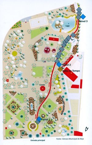
O Jardim Publico de Beja apresenta o "Trilho Geológico", uma mostra permanente da Geologia do Alentejo. Planeado com o objectivo de divulgar as geociências junto do grande público e das escolas, este percurso contempla fragmentos dos últimos 1000 milhões de anos da história geológica da região, desde o Neoproterozoico até a actualidade.
Como foi elaborado?
No percurso observam-se as principais formações rochosas do Alentejo, entre as quais se assinalam o minério de cobre de Neves Corvo, o mármore de Trigaches, apresentado nos "Cubos do Tempo", o xisto de Barrancos, o arenito de Alfundão com fosseis de ostras e o gabro de Beja.
As rochas foram recolhidas nas regiões de Barrancos, Beja, Castro Verde, Cereal, Ferreira do Alentejo, Grândola, Mértola, Santiago do Cacem e Vidigueira.
Paineis informativos complementam o trilho, assinalando outros aspectos geológicos da região desde os principais jazigos minerais metálicos e não metálicos, os vulcões antigos e as jazidas de fósseis. Realçam igualmente, a paleogeografia das distintas Eras geológicas, marcadoras de continentes e mares que existiram no passado.
Escala do Trilho
Ao longo de 200 m de trilho percorre-se, em cada metro, o equivalente a 5 milhões de anos (Ma) da história geológica.
O que vais aprender no local desta EC?
1 - Reconhecer as diversas rochas desta região tanto ao nível das suas características em superfícies meteorizadas e frescas.
2 - Poder viajar pelo tempo geológico percebendo a ordem de deposição dos principais tipos de rocha e a sua variação temporal.
3 - Perceber a riqueza associada aos diversos tipos de rocha desta região.
Como podem registar esta EC?
Para poderem fazer o log desta EC, têm de responder às seguintes perguntas e enviar as respostas para o owner da cache aqui:
- Quantos cubos do tempo existem neste trilho geológico?
- De que tamanho são os cubos do tempo?
- Qual é a idade mais antiga representada nos cubos do tempo e qual a mais recente representada nos mesmos cubos?
- Que rocha se encontra aos 310 Ma? E de que região é?

- Que rocha se encontra aos 230 Ma? E de que região é?
 Esta cache foi implantada no âmbito do projecto de investigação ATLANTERRA/GREEN MINES. O Projecto pretende assinalar alguns locais com geossítios importantes do Baixo Alentejo dedicados às minas e geologia da Faixa Piritosa Ibérica, a principal província metalogenética do país. Esta actividade será divulgada através do website ATLANTERRA.

ATLANTERRA – Geological trail (Beja)
Why here?
The Alentejo province in southern Portugal is undoubtedly one of the most important when it comes to geological sites, mineral occurrences, quarries and mines. In terms of metallic minerals it hosts one of the most famous copper-lead-zinc mines in the world: Neves Corvo, while in terms of ornamental stones it rivals some of the most famous Italian stone producing regions in both production and quality of stones.
 What does it represent?
It is with this in mind that the public gardens in central Beja pay homage to this fact and now host a 200 m-long geological trail that takes the visitor on a 1000 Ma trip though some of the most characteristic geology of this region showing the different rock types that outcrop in this region, the contained wealth of each rock type and the potential for further economic growth from each of the rock types. The trail has been laid out so that each metre the visitor travels; he/she is advancing 5 Ma through earth’s history. The trail has been dotted with some of the best geological samples from this region. Each sample has been painstakingly chosen to represent the most important lithologies and range in weight from 50 kg to 3500 kg. The samples have been cut so the internal structure of each lithology is clearly seen and in most cases the cut face has also been polished. Where fossils are chracteristic of a certain lithology, these are clearly marked and exemplified so the visitor can identify them easily.
The trail is accompanied by colour posters explaining the local geology of each geological era, outcrop locations with maps, photos of samples and a clear, concise and easy to follow explanation that can be understood by all.
The samples used are some of the best examples available in this region and well worth visiting for both geologists and laymen and this is the first example of such a trail within the Portuguese territory.
What can you learn?
The learning experience associated with this geological trail is developed in three ways at the site of the EarthCache:
-
A up close and practical method of getting to know what different lithologies look like and show the identifying characteristics of these lithologies in the field in both fresh and weathered surfaces.
-
A method of travelling through geological time in a small physical space by seeing the deposition of the different rock types and how these vary through time.
-
Seeing the types of rocks that bring wealth to the region.
How can you log this cache?
In order to log your find in this cache you have to undertake the trail and answer the following questions. Please send the answers to the cache owner using the e-mail address in the profile page.
- How many time cubes exist on this trail?
- What size are the time cubes?
- What age is depicted on the oldest time cube and in the youngest time cube?
- What rock type is shown at 310 Ma and where is it from?
- What rock type is shown at 230 Ma and where is it from?
This cache is an integral part of Project ATLANTERRA/GREEN MINES. This same Project intends to mark some of the best and most important geosites within the Lower Alentejo province. All sites are dedicated to the mines and geology of the Iberian Pyrite Belt, the most important metalogenic province in the country.
 The most exciting way to learn about the Earth and its processes is to get into the outdoors and experience it first-hand. Visiting an Earthcache is a great outdoor activity the whole family can enjoy. An Earthcache is a special place that people can visit to learn about a unique geoscience feature or aspect of our Earth. Earthcaches include a set of educational notes and the details about where to find the location (latitude and longitude). Visitors to Earthcaches can see how our planet has been shaped by geological processes, how we manage the resources and how scientists gather evidence to learn about the Earth. To find out more click HERE.