G2-Four Ways Multi-cache
-
Difficulty:
-

-
Terrain:
-
Size:  (micro)
Please note Use of geocaching.com services is subject to the terms and conditions
in our disclaimer.
The Walkern Walk Series
The location of this cache can be found at:
N51° 5(E-2).(H-G)(C-1)4 W000° 0(B+1).CA2
This cache is part of the Walkern Walk series based in
Walkern in Hertfordshire.
DO NOT use the coordinates at the top of this page as they are purely fictitious.
A good parking location and starting point would be at:
N51° 55.340 W000° 07.306
or if this car park area is busy, try somewhere around:
N51° 55.297 W000° 07.163
It would be a good idea to bring your Wellington boots as parts of the route can get quite muddy, especially during the winter months. Also, bring some bread with you to feed the ducks at 'The Key' coordinates - they will appreciate it, you can also wash your wellies in the stream/ford when you've finished.
Please also try to stick to the paths/edges of fields and not wander onto any ploughed or cropped fields which could damage any crops.
This cache:
DO NOT use the coordinates at the top of this page as they are purely fictitious. As I didn’t want to make this too easy (or too difficult), so I have devised a little work for you to do, it’s very easy so get the kids to work out the maths. You will need to find a key.
The key can be found at: N51° 55.341 W000° 07.317
- see also waypoint details below.
THIS IS THE KEY YOU WILL NEED, TO FIND ALL OF THE CACHES IN THE SERIES
At this location you will find a fire hydrant marker plate/sign. I think you know what I am talking about, it’s has a yellow background with a big letter H and various numbers on it.
At the top of the marker sign there are five numbers denoted as A,B,C,D,E.
Between the H at the top there are two numbers denoted as F,G.
Between the H at the bottom there is one number denoted as H.
For your information, the number at the top of the marker plate is merely a reference ID number. The number between the top of the H show the water main pipe diameter feeding the hydrant. The number between the bottom of the H is the distance from the marker plate to the hydrant.
G2-Four Ways – A 30ml bission canister
The location of this cache can be found at:
N51° 5(E-2).(H-G)(C-1)4 W000° 0(B+1).CA2
Please take a pen/pencil to sign the log.
|
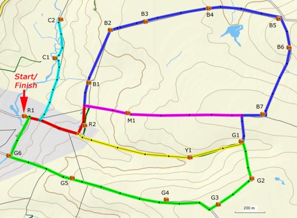
The 19 independent caches in the series form several routes behind Walkern as shown in the map and tables below. You can of course find the caches in any order you like.
NB. Due to the path being disabled between C2 and B2 on the 24/5/2009, the Cyan route unfortunately is now a dead-end.
|
 |
|
Simply choose one or more of the routes from the map above,
click here for a larger image of the map, (opens new window).
(Eg. Red, Blue and Green routes, then find each of the 15 caches in turn - R1, R2, B1, B2.....G5, G6. - Route total approx. 4.8Km).
Check/print the details using the links below.
Hint - To save paper when printing, collapse (click black minus sign left of) the 'Long Description' and the 'Overview Map' before printing the details.
|
|
Route
|
Length (metres)
|
Information |
|
Red
|
490
|
Easy pleasant route - should take between 15 to
40 minutes. |
|
Yellow
|
850
|
Easy route - should take between 10 to 30 minutes. |
|
Cyan
|
700
(One way)
|
Easy pleasant route - should take between 20 to
50 minutes. |
|
Blue
|
2400
|
Long route - should take between 40 to 80 minutes
(Muddy route in parts with possibility of puddles
around N51° 55.508' W000° 06.171' ) |
|
Magenta
|
790
|
Relatively easy route - should take between 10 to 30 minutes. |
|
Green
|
1900
|
Easy route - should take about 30 to 80 minutes. |
BIG congratulations to JF20938 on his FTF - 25th June 2009

Additional Hints
(Decrypt)
OBC ybt bayl