ORVEC: The Potholes EarthCache
-
Difficulty:
-

-
Terrain:
-

Size:  (other)
Please note Use of geocaching.com services is subject to the terms and conditions
in our disclaimer.

Potholes
_________________________________________
Visiting the Falls of the Ohio State Park is like walking millions of years back in time. All around and under your feet, each step you take, you will see sealife that died millions of years ago. This is all exposed on the Devonian limestone beds.
There are a few areas in the limestone that have circular bowl shaped depressions. These are called Potholes. A Pothole (or kettle-hole) is a formation in rivers caused by a whirlpool eroding a hole into rock. The abrasion is mainly caused by the circular motion of small sediments such as small stones (glacial till) in the river. The interiors of potholes tend to be smooth and regular. An example of this phenomena can be seen on the Devonian limestone beds. The objects that form the potholes here is glacial till that is move by the force of the Ohio river. The glacial till or is much harder than the softer limestone it is tumbling over. Sometimes the rocks are trapped in a crack or depression and begin swirling in a circular motion, eroding the softer limestone into a round 'pot' hole. And because this erosion activity has been going on for thousands of years, there are now hundreds of potholes in the river bed.


Potholes at the Falls
______________________________________________________
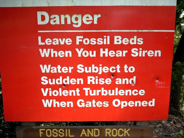
The fossil beds are open to the public. Please feel free to explore any areas you wish. But also be aware of the dangers (see sign) and remember, rocks and fossils here are protected by federal law. Collecting and removing rocks from the park is prohibited.
______________________________________________________
IF YOU HIKE - BEFORE YOU GO:
Call this number: (502) 775-5056 and listen to the one-minute recording.
The recording will give you important information on the river level above and below McAlpine dam. You will also hear how much water is running through the upper and lower spillways of the dam (one-mile apart). If the lower gauge is above 20 feet, the reef, and this feature, will be submerged.
______________________________________________________
Optional: To share your experience please post photo of yourself or your GPSr inside or beside The Potholes..
And to demonstrate the educational value of this EC, please email
ARF!
the answers to the following questions:
1. How many potholes are there within 100 feet of this waypoint?
2. How deep is the deepest pothole at this waypoint?
3. Is the process still active today?
4. What do you find inside these potholes?
_____________________________________________________
Please email your answers to :
ARF!
Do not wait on a reply from me. FOUND IT logs which do not meet requirements will be quietly removed.
Additional Hints
(No hints available.)